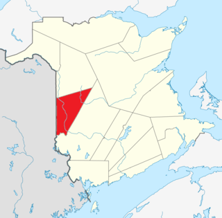
Carleton County is located in west-central New Brunswick, Canada.

Kent County is located in east-central New Brunswick, Canada. The county features a unique blend of cultures including Mi'kmaq, Acadian, and English. Some larger tourist attractions include the dune de Bouctouche, Kouchibouguac National Park, and Bonar Law Commons.

Northumberland County is located in northeastern New Brunswick, Canada.

Restigouche County is located in north-central New Brunswick, Canada. The county is named for the Restigouche River which flows through the county and is famous for its salmon pools, which have attracted wealthy American and Canadian tourists to the region's summer colonies for decades. Forestry dominates the local economy.

York County is located in west-central New Brunswick, Canada. The county contains the provincial capital, Fredericton. Outside the city, farming and forestry are two major industries in the county, which is bisected by the Saint John River. The Southwest Miramichi River flows through the northern section of the county.

Salisbury, New Brunswick is a community located in Westmorland County, New Brunswick, Canada.

Riverview is a town in Albert County, New Brunswick, Canada. Riverview is located on the south side of the Petitcodiac River, across from the larger cities of Moncton and Dieppe. Riverview has an area of 34 square kilometres (13 sq mi), and a population density of 564.6 inhabitants per square kilometre (1,462/sq mi). Riverview's slogan is "A Great Place To Grow". With a population of 19,667 in 2016, Riverview is the fifth largest municipality in New Brunswick, having a larger population than the cities of Edmundston, Bathurst, Campbellton, and Miramichi, despite its designation of "town".

Beaubassin East was an incorporated rural community in Westmorland County, New Brunswick, Canada. It held rural community status prior to 2023.

St. George is a community in the Rural Community of Eastern Charlotte, in Charlotte County, New Brunswick, Canada; it was a town until the end of 2022. It is located where the Magaguadavic River flows into the Bay of Fundy, between Passamaquoddy Bay and Lake Utopia.
Belledune is a Canadian village that straddles the boundary between Restigouche County and Gloucester County, New Brunswick.

Blackville is a community, formerly an incorporated village, in Northumberland County, New Brunswick, Canada.

Doaktown is a Canadian village in Northumberland County, New Brunswick.
Neguac is a Canadian village in Northumberland County, New Brunswick.
Boiestown is a Canadian community in the rural community of Upper Miramichi in Northumberland County, New Brunswick.
Ludlow is a civil parish in Northumberland County, New Brunswick, Canada.

Stanley is a civil parish in York County, New Brunswick, Canada.
McGivney is a settlement in New Brunswick, located 14.78 km SW of Boiestown, on the Canadian National Railway line, in Stanley Parish, York County.
Haut-Madawaska is a town in the New Brunswick Panhandle, Canada, formed by amalgamating the previous incorporated rural community of the same name with the village of Lac Baker. The town includes the former incorporated villages of Lac Baker, Baker-Brook, Clair, Saint-François de Madawaska and Saint-Hilaire.

