
The Black Hawk War was a conflict between the United States and Native Americans led by Black Hawk, a Sauk leader. The war erupted after Black Hawk and a group of Sauks, Meskwakis (Fox), and Kickapoos, known as the "British Band", crossed the Mississippi River, to the U.S. state of Illinois, from Iowa Indian Territory in April 1832. Black Hawk's motives were ambiguous, but he was apparently hoping to reclaim land that was taken over by the United States in the disputed 1804 Treaty of St. Louis.

Berrien County is a county in the U.S. state of Michigan. It is located at the southwest corner of the state's Lower Peninsula, located on the shore of Lake Michigan and sharing a land border with Indiana. As of the 2020 Census, the population was 154,316. The county seat is St. Joseph.

Manteno is a village in Kankakee County, Illinois, United States. The population was 9,210 at the 2020 census. It is part of the Kankakee-Bourbonnais-Bradley Metropolitan Statistical Area.

The Illinois Country — sometimes referred to as Upper Louisiana —was a vast region of New France claimed in the 1600s in what is now the Midwestern United States. While those names generally referred to the entire Upper Mississippi River watershed, French colonial settlement was concentrated along the Mississippi and Illinois Rivers in what is now the U.S. states of Illinois and Missouri, with outposts on the Wabash River in Indiana. Explored in 1673 from Green Bay to the Arkansas River by the Canadien expedition of Louis Jolliet and Jacques Marquette, the area was claimed by France. It was settled primarily from the Pays d'en Haut in the context of the fur trade, and in the establishment of missions from Canada by French Catholic religious orders. Over time, the fur trade took some French to the far reaches of the Rocky Mountains, especially along the branches of the broad Missouri River valley. The French name, Pays des Ilinois, means "Land of the Illinois [plural]" and is a reference to the Illinois Confederation, a group of related Algonquian native peoples.

Starved Rock State Park is a state park in the U.S. state of Illinois, characterized by the many canyons within its 2,630 acres (1,064 ha). Located just southeast of the village of Utica, in Deer Park Township, LaSalle County, Illinois, along the south bank of the Illinois River, the park hosts over two million visitors annually, the most for any Illinois state park.

The Kankakee River is a tributary of the Illinois River, approximately 133 miles (214 km) long, in the Central Corn Belt Plains of northwestern Indiana and northeastern Illinois in the United States. At one time, the river drained one of the largest wetlands in North America and furnished a significant portage between the Great Lakes and the Mississippi River. Significantly altered from its original channel, it flows through a primarily rural farming region of reclaimed cropland, south of Lake Michigan.

The Treaty of St. Mary's may refer to one of six treaties concluded in fall of 1818 between the United States and Natives of central Indiana regarding purchase of Native land. The treaties were
White Rock is an unincorporated community in Huron County in the U.S. state of Michigan. The community is located within Sherman Township. As an unincorporated community, White Rock has no legal autonomy, defined boundaries, or population statistics of its own. It is located at 43°42′35″N82°36′31″W, about three miles north of Forestville and about nine miles south of Harbor Beach on M-25 at the junction with White Rock Road.
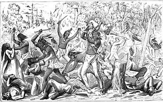
The Indian Creek Massacre occurred on May 21, 1832 with the attack by a party of Native Americans on a group of United States settlers in LaSalle County, Illinois following a dispute about a settler-constructed dam that prevented fish from reaching a nearby Potawatomi village. The incident coincided with the Black Hawk War, but it was not a direct action of the Sauk leader Black Hawk and conflict with the United States. The removal of the dam was asked, was rejected by the settlers and between 40 and 80 Potawatomis and three Sauks attacked and killed fifteen settlers, including women and children. Two young women kidnapped by the Indians were ransomed and released unharmed about two weeks later.

The Iroquois River is a 103-mile-long (166 km) tributary of the Kankakee River in the Central Corn Belt Plains of northwestern Indiana and northeastern Illinois in the United States. It was named for the Iroquois people. Via the Kankakee and Illinois rivers, it is part of the watershed of the Mississippi River.

Rockville Township is one of seventeen townships in Kankakee County, Illinois, USA. As of the 2010 census, its population was 879 and it contained 326 housing units. It was formerly a township of Will County until Kankakee County was created. The township's name may have been derived from a Potawatomi village known to the pioneers as "Little Rock Village."

Kankakee River State Park is an Illinois state park on 4,000 acres (1,619 ha) primarily in Kankakee and Will Counties, Illinois, United States. Originally, 35 acres (14 ha) of land was donated by Ethel Sturges Dummer for the creation of the state park in 1938. Another 1,715 acres (694 ha) was donated by Commonwealth Edison in 1956, which again donated more land in 1989. The islands of Smith, Hoffman, Langham, and Willow are all located inside the park on the Kankakee River.

The Potawatomi Trail of Death was the forced removal by militia in 1838 of about 859 members of the Potawatomi nation from Indiana to reservation lands in what is now eastern Kansas.

The Yellow River is a 62.3-mile-long (100.3 km) tributary of the Kankakee River in the Central Corn Belt Plains ecoregion, located in northern Indiana in the United States. Via the Kankakee and Illinois rivers, it is part of the watershed of the Mississippi River, draining an area of 427 square miles (1,110 km2).

Shabbona or Shab-eh-nay, sometimes referred to as Shabonee and Shaubena, was an Ottawa tribe member who became a chief within the Potawatomi tribe in Illinois during the 19th century.
Fish Lake is an unincorporated community and census-designated place in Lincoln Township, LaPorte County, Indiana, United States. It is located where Indiana State Road 4 passes between Upper Fish Lake and Lower Fish Lake. These lakes feed the Kankakee River. As of the 2010 census, the population of the community was 1,016.
Chief Gomo was a 19th-century Potawatomi chieftain. He and his brother Senachwine were among the more prominent war chiefs to fight alongside Black Partridge during the Peoria War.
Indian Creek, also known as Big Indian Creek, is a 51.5-mile-long (82.9 km) tributary of the Fox River in Lee, LaSalle, and DeKalb counties in Illinois.
The Treaty of St. Louis is the name of a series of treaties signed between the United States and various native tribes from 1804 through 1824. The fourteen treaties were all signed in the St. Louis, Missouri area.
