Llangammarch Wells or simply Llangammarch is a village in the community of Llangamarch in Powys, Wales, lying on the Afon Irfon, and in the historic county of Brecknockshire (Breconshire).

The Cambrian Mountains are a series of mountain ranges in Wales.
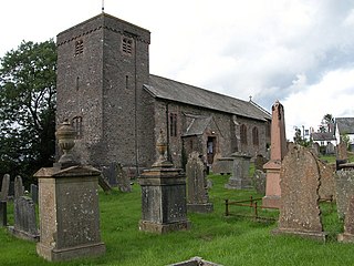
Cefnllys was a medieval town in Radnorshire in central Wales. Only St Michael's Church remains standing, with mounds indicating the remains of other buildings existing before the decline of the town in the 19th century. Close by on the hill known as Castle Rock are the remains of what is known as Cefnllys Castle. Almost encircling the hill, church and remains of the town is the River Ithon which continues to Llandrindod Wells a little over a mile away.
Cwm-Hwnt is a tiny hamlet to the west of Rhigos and south of Cefn Rhigos in the Cynon Valley, one of the South Wales Valleys.

Clwyd South is a constituency of the National Assembly for Wales. It elects one Assembly Member by the first past the post method of election. Also, however, it is one of nine constituencies in the North Wales electoral region, which elects four additional members, in addition to nine constituency members, to produce a degree of proportional representation for the region as a whole.
The Afon Crafnant is a tributary of the River Conwy, which is the main river of the Conwy valley in north-west Wales.

The A4054 is an A Road connecting Llandaff, Cardiff with Cefn-Coed-y-Cymmer in Wales and mostly follows the former route of the A470.

Cefn Cyfarwydd is a ridge in Conwy county borough, north Wales. It is located above the village of Trefriw on the western side of the Conwy valley, and dramatically separates Cwm Cowlyd and the rugged mountains of the Carneddau from the greener, lusher Conwy valley.

Cyrniau Nod is a mountain summit in north east Wales. It is a former Marilyn, the Marilyn summit now being the nearby Foel Cedig. Its summit has the Snowdonia National Park boundary running through it. A number of rivers and streams rise from near the mountain including Afon Tanat, Afon Cedig and Nant Ystrad-y-Groes.

The Epynt Way is a long-distance path created by the Ministry of Defence in 2004 around the perimeter of its 'Sennybridge Training Area (SENTA)' and artillery range on Mynydd Epynt in Powys, Wales. There is, understandably, virtually no public access across the land used by the MoD, pre-existing public rights of way and public roads having been closed, with only one or two exceptions. The establishment of the Epynt Way, section by section in recent years has gone some way to compensating for that reduction in public access across the area.
Cefn Gwyntog is a top of Cyrniau Nod in north east Wales. It forms a part of the Berwyn range known as the Hirnantau. Its summit lies just outside the Snowdonia National Park.

Stac Rhos is a top of Pen y Boncyn Trefeilw in north east Wales. It forms a part of the Berwyn range called the Hirnantau.
Plaskynaston Lane is a demolished football stadium in Cefn Mawr, Wrexham, Wales. It was the home stadium of Cefn Druids A.F.C. of the Cymru Alliance. The stadium held 2,000 spectators.

Long Mountain is a hill located east of Welshpool in Powys, Wales. It crosses the boundaries of Powys and Shropshire, and hence also of England and Wales.

Duhonw is a rural community in Powys, Wales, to the south of Builth Wells, in the historic county of Breconshire, comprising scattered farms and dwellings. Covering an area of 4,376 hectares (16.90 sq mi), it is bounded to its north by the Afon Irfon, to its south by Mynydd Epynt and Banc y Celyn (472m) and to its east the rivers Duhonw and Wye. Llangammarch Wells' is to its west.
Crychan Forest Tracks is a Site of Special Scientific Interest in Carmarthen & Dinefwr, Wales. It was chosen as a special stage in the British Rally from 2006 to 2008.

Llanfrynach is a village and community in the county of Powys, Wales, and the historic county of Brecknockshire. The population of the community as taken at the 2011 census was 571. It lies just to the southeast of Brecon in the Brecon Beacons National Park. The village sits astride the Nant Menasgin, a right bank tributary of the River Usk. The B4558 passes just to its north and the Monmouthshire and Brecon Canal also passes around the village. The Welsh name signifies the 'church of Brynach'.

Coity Higher is a community in Bridgend County Borough, south Wales. It contains the north western suburbs of Bridgend which includes the villages of Litchard and Coity. The southern boundary of the community adjoins the community of Brackla, while the northern border is defined by the M4 motorway. Notable buildings and landmarks within the community include Coity Castle, Parc Prison, the 14th century Church of St Mary, Pendre Hospital, Ty Mawr house and a burial chamber. At the 2001 census, the community's population was 835, being re-measured at 6,078 t the 2011 Census.
Llanwrtyd Wells is the name of an electoral ward in mid Powys, Wales. It covers three local government communities and elects a councillor to Powys County Council.
