Fishbourne Roman Palace or Fishbourne Villa is in the village of Fishbourne, near Chichester in West Sussex. The palace is the largest known Roman residence north of the Alps, and has an unusually early date of 75 AD, around thirty years after the Roman conquest of Britain.

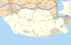
Llantwit Major is a town and community in Wales on the Bristol Channel coast. It is one of four towns in the Vale of Glamorgan, with the third largest population after Barry and Penarth, and ahead of Cowbridge. It is 4+1⁄2 miles (7.2 km) from Cowbridge, 9 miles (14 km) from Bridgend, 10 miles (16 km) from Barry, and 15 miles (24 km) from Cardiff. It had a population of 9,530 in 2021.
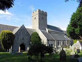
St Illtyd's Church is a church complex in Llantwit Major, Vale of Glamorgan, southeast Wales. It is located at the site of the oldest college in the United Kingdom, once believed to have been founded as Côr Tewdws c. AD 395 by the Roman Emperor Theodosius II. It is now generally accepted as having been founded by St. Illtud c. AD 508, from whom it derives its name. The current church building was built in the 11th century by the Normans, with portions being rebuilt in the 13th and 15th centuries. The church building is one of the oldest and best-known parish churches in Wales. It is a grade I listed building, or building of exceptional interest, and has been called both the "Westminster Abbey of Wales" for its unique collection of carved stones and effigies, and "the most beautiful church in Wales."

Lydney Park is a 17th-century country estate surrounding Lydney House, located at Lydney in the Forest of Dean district in Gloucestershire, England. It is known for its gardens and Roman temple complex.

Chedworth Roman Villa is located near Chedworth, Gloucestershire, England and is a scheduled monument. It is one of the largest and most elaborate Roman villas so far discovered in Britain and one with the latest occupation beyond the Roman period. The villa was built in phases from the early 2nd century to the 5th century, with the 4th-century construction transforming the building into an elite dwelling arranged around three sides of a courtyard. The 4th-century building included a heated and furnished west wing containing a dining-room (triclinium) with a fine mosaic floor, as well as two separate bathing suites: one for damp-heat and one for dry-heat.
Piddington Roman Villa is the remains of a large Roman villa at Piddington, Northamptonshire, about 6 miles (9.7 km) south-east of Northampton, a county in the East Midlands of England.
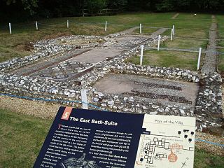
Rockbourne Roman Villa is a Roman courtyard villa excavated and put on public display in the village of Rockbourne in the English county of Hampshire. The villa was discovered in 1942 by a local farmer and excavated by A. T. Morley Hewitt over the next thirty years.
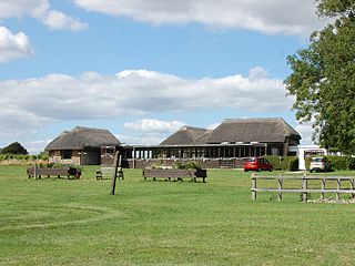
Bignor Roman Villa is a large Roman courtyard villa which has been excavated and put on public display on the Bignor estate in the English county of West Sussex. It is well known for its high quality mosaic floors, which are some of the most complete and intricate in the country. It is managed by the Bignor Roman Villa Charitable Trust, a registered charity.

Brading Roman Villa was a Roman courtyard villa which has been excavated and put on public display in Brading on the Isle of Wight.

Littlecote Roman Villa is an extensive and exceptional Roman villa, with associated religious complex, at Littlecote Park just over a mile west of Hungerford, Berkshire. It has been excavated and is on display to the public in the grounds of the estate.

The Low Ham Roman Villa was a Roman courtyard villa located near Low Ham in the civil parish of High Ham in the English county of Somerset. It is best known for the extraordinary figured mosaic depicting the story of Aeneas and Dido.
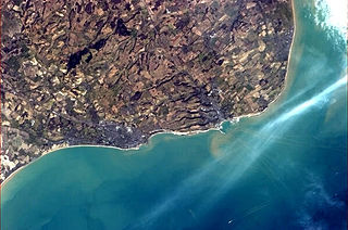
The history of Folkestone stretches back to ancient times, with evidence of human habitation dating to the Mesolithic and Paleolithic ages over 12,000 years ago. Its close proximity to the Continent means that it has often been a point of transit for migrating peoples. The area has successively been occupied by groups of Britons, Romans and Saxons. During the Iron Age, a large oppidum and quern-stone workshop were situated on the eastern headlands of the bay. By the Roman era, it had been transformed into a large Roman Villa overlooking the sea.

Oplontis is an ancient Roman archaeological site, located in the town of Torre Annunziata, south of Naples in the Campania region of southern Italy. The excavated site comprises two Roman villas, the best-known of which is Villa A, the so-called Villa Poppaea.

The Shapwick Hoard is a hoard of 9,262 Roman coins found at Shapwick, Somerset, England in September 1998. The coins dated from as early as 31–30 BC up until 224 AD. The hoard also notably contained two rare coins which had not been discovered in Britain before, and the largest number of silver denarii ever found in Britain.

Sparsholt Roman Villa was a Roman villa near the village of Sparsholt, Hampshire, England. It was constructed in phases from the 2nd to the 5th century, and then abandoned. It was excavated in 1965–72. Nothing is visible at the site today, but finds from the excavations are on display in Winchester City Museum, and one wing of the villa has been reconstructed at Butser Ancient Farm.
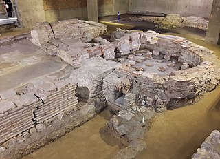
Billingsgate Roman House and Baths is an archaeological site in Londinium. The best preserved parts of the house are a bath with hypocausts.

Folkestone Roman Villa, also referred to as the East Bay Site, is a villa built during the Roman Occupation of Britain, and is located in East Wear Bay near the port town of Folkestone, in Kent, England. The villa is situated on a cliff top overlooking the English Channel, with views of the French coast at Boulogne on a clear day. It is situated near the start of the North Downs Trackway, and the area has been inhabited for thousands of years, with archeological finds in the area and at the villa site dating back to the Mesolithic and Neolithic ages. The villa was built around A. D. 75, and was almost certainly built within the confines of a preexisting Iron Age settlement.

Totternhoe Roman villa is on Church Farm, Church Road, in Totternhoe, Bedfordshire, England. No sign of it is now visible, as it has been filled in and grassed over.

Boxmoor Roman Villa is a ruined Roman Villa at Boxmoor, Hemel Hempstead, Hertfordshire. The remains have been excavated, but they are now buried. The Roman villa was occupied from the first century AD up to the Fourth century.
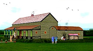
The Carsington Roman Villa is a Roman villa at Scow Brook, Carsington near Wirksworth, Derbyshire, England.
