Pentraeth is a village and community on the island of Anglesey, North Wales, at grid reference SH523786. The Royal Mail postcode begins LL75. The community population taken at the 2011 census was 1,178. The village itself having a population of 557.

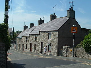
Moelfre is a village, a community and, until 2012, an electoral ward on the north-east coast of the Isle of Anglesey in Wales. The community area covers the village and harbour, and several smaller, dispersed settlements. It includes six scheduled Iron Age hut groups and many other sites of archaeological interest. The harbour was formerly a local fishing port; a lifeboat station has been based here since 1854. Among many shipwrecks off the coast was that of the Royal Charter in 1859. Near the modernised lifeboat station is the RNLI Seawatch Centre. The coastline includes a rocky headland north of the village and a large sandy beach at Lligwy Bay, both traversed by the Anglesey Coastal Path. The 2011 census measured the village population as 710. It was estimated at 614 in 2019.

The Isle of Anglesey County Council is the local authority for the county of Anglesey, one of the principal areas of Wales. Since 2022 the council has 35 councillors who represent 11 multi-member electoral wards.

Rhosyr is a community in the far southern corner of Anglesey, Wales. It includes the villages of Dwyran and Newborough, Llangeinwen and Llangaffo.

Bodffordd is a village and community in central Anglesey, Wales. As of the 2011 census, the community's population was 960. The community includes the hamlets of Trefor, Heneglwys and Bodwrog.

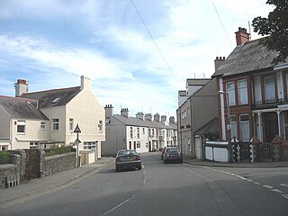
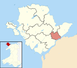
Llanbedrgoch is a hamlet and post town, a mile south of the town of Benllech and west of Red Wharf Bay, on the island of Anglesey, north Wales. The parish church is St Peter's Church, Llanbedrgoch, a Grade II* listed building that dates back to the 15th century.
Llanddyfnan is a village and community in the Welsh county of Anglesey, located 3.5 miles (5.6 km) north east of Llangefni, 6.6 miles (10.6 km) north west of Menai Bridge and 7.1 miles (11.4 km) west of Beaumaris.
Kingsland is an area in the community of Holyhead, Anglesey, Wales.
Morawelon (Môrawelon) is an area and community electoral ward in the town of Holyhead, Anglesey, Wales.

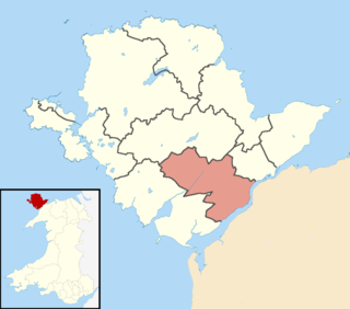
Twrcelyn is an electoral ward in the north of Anglesey, Wales. It includes the communities of Amlwch, Llanbadrig, Llaneilian, and Rhosybol. Twrcelyn elects three county councillors to the Isle of Anglesey County Council.

The 2017 Welsh local elections were held on 4 May 2017 to elect members of all 22 local authorities in Wales. This included the Isle of Anglesey, which was previously up for election in 2013 due to having its elections delayed for a year. Community council elections also took place on the same day. These local elections were held as part of the 2017 local elections in the United Kingdom. Apart from Anglesey, the last elections were held in 2012. Normally these elections take place every four years, but the 2017 elections were postponed for a year in order to avoid clashing with the 2016 Welsh Assembly election, which itself had been postponed by a year to avoid clashing with the 2015 general election.
The Isle of Anglesey electoral boundary changes in 2012 reduced the numbers of electoral wards to the Isle of Anglesey County Council from 40 to 11. This led to the postponement of local government elections in the county by 12 months. The changes were confirmed by the Isle of Anglesey Order 2012 in October 2012.
The 2008 Isle of Anglesey Council election took place on Thursday 1 May 2008 to elect members of the Isle of Anglesey County Council in Wales. This was the same day as other United Kingdom local elections. The previous full council election was on 10 June 2004 and the next full council election was held on 2 May 2013.

Caergybi is an electoral ward in Holyhead, Anglesey, Wales. It includes the northern half of the community including the town centre and port. Caergybi elects three county councillors to the Isle of Anglesey County Council. Caergybi includes the community wards of Town, London Road, Morawelon, Porthafelin and Parc a'r Mynydd, which elect representatives to Holyhead Town Council.

Canolbarth Môn is an electoral ward in the centre of Anglesey, Wales. It includes the communities of Bryngwran, Bodffordd, Llangefni, and Trewalchmai, and the majority of Llanddyfnan. Canolbarth Môn elects three county councillors to the Isle of Anglesey County Council.
Maeshyfryd is an area southwest of the port and town centre of Holyhead in Anglesey, Wales. It was formerly an electoral ward to the county council.

Bro Aberffraw is an electoral ward in the southern corner of Anglesey, Wales. It comprises the three communities of Aberffraw, Bodorgan and Rhosyr. Canolbarth Môn elects two county councillors to the Isle of Anglesey County Council.
Bro Rhosyr is an electoral ward in the south of Anglesey, Wales, created in 2012.
Aethwy is the name of an electoral ward in the south of Anglesey, Wales, created in 2012. It contains the population centres of Menai Bridge and Llanfair PG.
Ynys Gybi is the name of an electoral ward in the west of Anglesey, Wales, created in 2012. It covers the most part of Holy Island, whose name is Ynys Gybi in Welsh.
