
The smallmouth bass is a species of freshwater fish in the sunfish family (Centrarchidae) of the order Perciformes. It is the type species of its genus. One of the black basses, it is a popular game fish sought by anglers throughout the temperate zones of North America, and has been spread by stocking—as well as illegal introductions—to many cool-water tributaries and lakes in Canada and more so introduced in the United States. The maximum recorded size is approximately 27 inches and 12 pounds. The smallmouth bass is native to the upper and middle Mississippi River basin, the Saint Lawrence River–Great Lakes system, and up into the Hudson Bay basin.The world record size was over 11 pounds caught in the lake Dale Hollow, on the Kentucky—Tennessee border. Its common names include smallmouth, bronzeback, brown bass, brownie, smallie, bronze bass, and bareback bass.

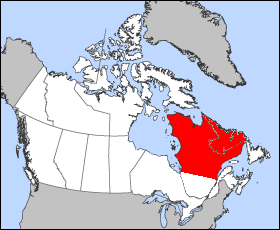
Labrador is a geographic and cultural region within the Canadian province of Newfoundland and Labrador. It is the primarily continental portion of the province and constitutes 71% of the province's area but is home to only 6% of the province's population. It is separated from the island of Newfoundland by the Strait of Belle Isle. It is the largest and northernmost geographical region in Atlantic Canada.
The Labrador Peninsula, or Quebec-Labrador Peninsula, is a large peninsula in eastern Canada. It is bounded by the Hudson Bay to the west, the Hudson Strait to the north, the Labrador Sea to the east, and the Gulf of Saint Lawrence to the southeast. The peninsula includes the region of Labrador, which is part of the province of Newfoundland and Labrador, and the regions of Saguenay–Lac-Saint-Jean, Côte-Nord, and Nord-du-Québec, which are in the province of Quebec. It has an area of 1,400,000 km2 (541,000 sq mi).

The Deschutes River in central Oregon is a major tributary of the Columbia River. The river provides much of the drainage on the eastern side of the Cascade Range in Oregon, gathering many of the tributaries that descend from the drier, eastern flank of the mountains. The Deschutes provided an important route to and from the Columbia for Native Americans for thousands of years, and then in the 19th century for pioneers on the Oregon Trail. The river flows mostly through rugged and arid country, and its valley provides a cultural heart for central Oregon. Today the river supplies water for irrigation and is popular in the summer for whitewater rafting and fishing.

The Churchill River, formerly known by other names, is a river in Newfoundland and Labrador, Canada. It flows east from the Smallwood Reservoir into the Atlantic Ocean via Lake Melville. The river is 856 km (532 mi) long and drains an area of 79,800 km2 (30,800 sq mi), making it the longest river in Atlantic Canada.
Twin Falls was the site of a hydroelectric power station was developed there by the British Newfoundland Development Corporation (Brinco) to deliver power to mining operations in Labrador City and Wabush.

Curecanti National Recreation Area is a National Park Service unit located on the Gunnison River in western Colorado. Established in 1965, Curecanti is responsible for developing and managing recreational facilities on three reservoirs, Blue Mesa Reservoir, Morrow Point Reservoir and Crystal Reservoir, constructed on the upper Gunnison River in the 1960s by the U.S. Bureau of Reclamation to better utilize the vital waters of the Colorado River and its major tributaries. A popular destination for boating and fishing, Curecanti offers visitors two marinas, traditional and group campgrounds, hiking trails, boat launches, and boat-in campsites. The state's premiere lake trout and Kokanee salmon fisheries, Curecanti is a popular destination for boating and fishing, and is also a popular area for ice-fishing in the winter months.

Lake Hartwell is a man-made reservoir bordering Georgia and South Carolina on the Savannah, Tugaloo, and Seneca Rivers. Lake Hartwell is one of the southeast's largest and most popular recreation lakes. The lake is created by Hartwell Dam located on the Savannah River seven miles (11 km) below the point at which the Tugaloo and Seneca Rivers join to form the Savannah. Extending 49 miles (79 km) up the Tugaloo and 45 miles (72 km) up the Seneca at normal pool elevation, the lake comprises nearly 56,000 acres (230 km²) of water with a shoreline of 962 miles (1,548 km). The entire Hartwell "Project" contains 76,450 acres (309 km²) of land and water. I-85 bisects Hartwell Lake and makes the area easily accessible to visitors.

The Smallwood Reservoir is the reservoir created for the Churchill Falls Generating Station in the western part of Labrador, Canada. Unlike other reservoirs, water is contained not by a single large dam, but by a series of 88 dikes that total 64 km (40 mi) in length in the drainage area of the Churchill River. It is named in honour of Joey Smallwood, the first premier of Newfoundland.

The first brief European contact with Newfoundland and Labrador came c. AD 1000 when the Vikings briefly settled in L'Anse aux Meadows. In 1497, European explorers and fishermen from England, Portugal, Holland, France, and Spain began exploration. Fishing expeditions came seasonally; the first small permanent settlements appeared around 1630. Catholic-Protestant religious tensions were high but mellowed after 1860. The British colony voted against joining Canada in 1869 and became an independent dominion in the early 20th century. Fishing was always the dominant industry, but the economy collapsed in the Great Depression of the 1930s and the people voluntarily relinquished their independence to become a British colony again. Prosperity and self-confidence returned during the WW2, and after the intense debate, the people voted to join Canada in 1949.

Lake Cascade (formerly Cascade Reservoir, is a reservoir in the western United States, on the North Fork of the Payette River in Valley County, Idaho. Located in the Boise National Forest, it has a surface area of 47 square miles, and is the fourth largest lake or reservoir in the state. The closest cities are Cascade, Donnelly, and McCall, all in the Long Valley of Valley County.

The Canadian province of Newfoundland and Labrador is governed by a unicameral legislature, the House of Assembly, which operates under the Westminster model of government. The executive function of government is formed by the Lieutenant Governor, the premier and his or her cabinet. The politics of Newfoundland and Labrador is defined by a long history, liberal democratic political institutions and a unique political culture.
McGregor Lake is an elongated reservoir in Southern Alberta. McGregor Lake was created in 1920 by the completion of two dams bracketing water flowing through in Snake Valley. It is situated 100 km (62 mi) southeast of Calgary in the Vulcan County.

The Cabonga Reservoir is a man-made lake in central Quebec, Canada, with a total surface area of 677 square kilometres (261 sq mi) and a net area of 484 square kilometres (187 sq mi). It is located on the boundary between the unorganized territories of Lac-Pythonga and Réservoir-Dozois, and fully within the La Vérendrye Wildlife Reserve. The First Nations reserve of Rapide Lake is on its western shores.

Wickiup Reservoir is the second-largest reservoir in the U.S. state of Oregon. It is located 60 miles (97 km) southwest of Bend, and is the largest of the Cascade Lakes. Wickiup Reservoir is close to the Twin Lakes, Davis Lake, Crane Prairie Reservoir, Cultus Lake, and Little Cultus Lake. The reservoir is located within the Deschutes National Forest and the Fort Rock Ranger District, near the Cascade Lakes Scenic Byway.

The Churchill Falls Generating Station is a hydroelectric underground power station in Labrador. At 5,428 MW, it is the tenth largest in the world, and the second-largest in Canada, after the Robert-Bourassa generating station in northwestern Quebec.
Michikamau Lake, in Labrador, Canada, was absorbed into Smallwood Reservoir upon the completion of the Churchill Falls Generating Station in 1974. The lake makes up the largest part of the eastern section of the reservoir, while Lobstick Lake, also absorbed in Smallwood's creation, makes up the largest part of the western section.
A lobstick is a traditional marker found in a boreal forest created by a coniferous tree. Lobstick may also refer to a number of places in Canada:

The Naskaupi River is the second largest river in Labrador, Canada. Its drainage basin lies north of that of Labrador's longest river, the Churchill River. Like the Churchill River, it drains into the western end of the estuary known as Lake Melville.

