
The Northrop Grumman E-8 Joint Surveillance Target Attack Radar System is a United States Air Force airborne ground surveillance, battle management and command and control aircraft. It tracks ground vehicles and some aircraft, collects imagery, and relays tactical pictures to ground and air theater commanders. The aircraft is operated by both active duty U.S. Air Force and Air National Guard units and also carries specially trained U.S. Army personnel as additional flight crew.

In military operations, reconnaissance or scouting is the exploration of an area by military forces to obtain information about enemy forces, terrain, and other activities.
In modern use, the order of battle of an armed force participating in a military operation or campaign shows the hierarchical organization, command structure, strength, disposition of personnel, and equipment of units and formations of the armed force. Various abbreviations are in use, including OOB, O/B, or OB, while ORBAT remains the most common in the United Kingdom. An order of battle is distinct from a table of organisation, which is the intended composition of a given unit or formation according to the military doctrine of its armed force. Historically, an order of battle was the order in which troops were positioned relative to the position of the army commander or the chronological order in which ships were deployed in naval situations.

Civil-Military Co-operation (CIMIC) is the means by which a military commander connects with civilian agencies active in a theatre of operations.
Measurement and signature intelligence (MASINT) is a technical branch of intelligence gathering, which serves to detect, track, identify or describe the distinctive characteristics (signatures) of fixed or dynamic target sources. This often includes radar intelligence, acoustic intelligence, nuclear intelligence, and chemical and biological intelligence. MASINT is defined as scientific and technical intelligence derived from the analysis of data obtained from sensing instruments for the purpose of identifying any distinctive features associated with the source, emitter or sender, to facilitate the latter's measurement and identification.
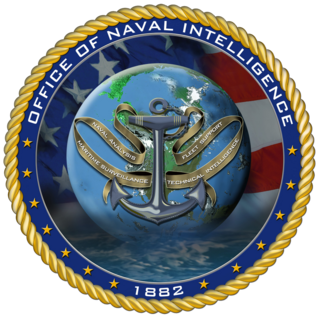
The Office of Naval Intelligence (ONI) is the military intelligence agency of the United States Navy. Established in 1882 primarily to advance the Navy's modernization efforts, it is the oldest member of the U.S. Intelligence Community and serves as the nation's premier source of maritime intelligence.
Network-centric warfare, also called network-centric operations or net-centric warfare, is a military doctrine or theory of war that seeks to translate an information advantage, enabled in part by information technology, into a competitive advantage through the robust computer networking of well informed geographically dispersed forces. It is based on ideas of marshal of USSR Nikolai Ogarkov, set out by him in early 1980s. It was pioneered by the United States Department of Defense in the 1990s.
The United States Marine Corps Reconnaissance Battalions are the Special Operations Capable reconnaissance assets of Marine Air-Ground Task Force that provide division-level ground and amphibious reconnaissance to the Ground Combat Element within the United States Marine Corps. Division reconnaissance teams are employed to observe and report on enemy activity and other information of military significance in close operations. The Military Occupational Specialty code for Reconnaissance Marine is 0321.
A common operational picture (COP) is a single identical display of relevant (operational) information shared by more than one Command. A COP facilitates collaborative planning and combined execution and assists all echelons to achieve situational awareness.
Battlespace or battle-space is a term used to signify a unified military strategy to integrate and combine armed forces for the military theatre of operations, including air, information, land, sea, cyber and outer space to achieve military goals. It includes the environment, factors, and conditions that must be understood to successfully apply combat power, protect the force, or complete the mission. This includes enemy and friendly armed forces, infrastructure, weather, terrain, and the electromagnetic spectrum within the operational areas and areas of interest.

The Battlefield Airborne Communications Node (BACN) is a United States Air Force (USAF) airborne communications relay and gateway system carried by the unmanned EQ-4B and the manned Bombardier E-11A aircraft. BACN enables real-time information flow across the battlespace between similar and dissimilar tactical data link and voice systems through relay, bridging, and data translation in line-of-sight and beyond-line-of-sight situations. Its ability to translate between dissimilar communications systems allows them to interoperate without modification.

Blue force tracking is a United States military term for a GPS-enabled capability that provides military commanders and forces with location information about friendly military forces. In NATO military symbology, blue typically denotes friendly forces. The capability provides a common picture of the location of friendly forces and therefore is referred to as the blue force tracker. When all capitalized, the term refers to a specific defense contractors' system, but the capability is found in many military and civilian mobile apps.
Area of responsibility (AOR) is a pre-defined geographic region assigned to Combatant commanders of the Unified Command Plan (UCP), that are used to define an area with specific geographic boundaries where they have the authority to plan and conduct operations; for which a force, or component commander bears a certain responsibility. The term may also be used in other countries worldwide but it originated within the United States Armed Forces. This system is designed to allow a single commander to exercise command and control of all military forces in the AOR, regardless of their branch of service.
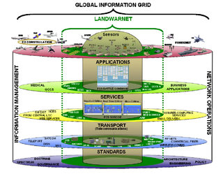
LandWarNet (LWN) is the United States Army’s contribution to the Global Information Grid (GIG) that consists of all globally interconnected, end-to-end set of Army information capabilities, associated processes, and personnel for collecting, processing, storing, disseminating, and managing information on demand supporting warfighters, policy makers, and support personnel. It includes all Army and leveraged Department of Defense (DOD)/Joint communications and computing systems and services, software, data security services, and other associated services. LandWarNet exists to enable the warfighter through Mission Command, previously described as Battle Command. Other U.S. service equivalent efforts to LandWarNet include the Navy's "FORCEnet" and the Air Force's "C2 Constellation."
The FCS Network - Brigade Combat Team (BCT) Network consists of five layers that combine to provide seamless delivery of data to forward-deployed Army units.

Special reconnaissance (SR) is conducted by small units of highly trained military personnel, usually from special forces units or military intelligence organizations, who operate behind enemy lines, avoiding direct combat and detection by the enemy. As a role, SR is distinct from commando operations, but both are often carried out by the same units. The SR role frequently includes covert direction of air and missile attacks, in areas deep behind enemy lines, placement of remotely monitored sensors, and preparations for other special forces. Like other special forces, SR units may also carry out direct action and unconventional warfare, including guerrilla operations.

Battle command (BC) is the discipline of visualizing, describing, directing, and leading forces in operations against a hostile, thinking, and adaptive enemy. Battle command applies leadership to translate decision into actions, by synchronizing forces and warfighting functions in time, space, and purpose, to accomplish missions. Battle command refers both to processes triggered by commanders and executed by soldiers and to the system of systems (SoS) that directly enables those processes.
The Army will continue the development and fielding of an incremental ground tactical network capability to all Army brigade combat teams. This network is a layered system of interconnected computers and software, radios, and sensors within the Brigade Combat Team (BCT). The BCT network is essential to enable Unified Battle Command and will be delivered to the Army's Brigade Combat Teams in increasing capability increments. The first increment is currently finishing SDD developmental and operational testing and will be delivered to Infantry Brigade Combat Teams in the form of Network Integration Kits (B-kits) with E-IBCT.

The Battle of Kamdesh took place during the war in Afghanistan. It occurred on October 3, 2009, when a force of 300 Taliban assaulted the American Combat Outpost ("COP") Keating near the town of Kamdesh in Nuristan Province in eastern Afghanistan. The attack was the bloodiest battle for US forces since the Battle of Wanat in July 2008, which occurred 20 miles (32 km) away from Kamdesh. The attack on COP Keating resulted in 8 Americans killed and 27 wounded while the Taliban suffered an estimated 150 killed.

USA-231, or ORS-1 is an American reconnaissance satellite which was launched in 2011 from NASA’s Wallops Flight Facility, Virginia by a Minotaur I launch vehicle. It is the first operational satellite of the Operationally Responsive Space Office. It is equipped with a SYERS 2A sensor.