
An isthmus is a narrow piece of land connecting two larger areas across an expanse of water by which they are otherwise separated. A tombolo is an isthmus that consists of a spit or bar, and a strait is the sea counterpart of an isthmus.

The Crinan Canal between Crinan and Ardrishaig in Argyll and Bute in the west of Scotland is operated by Scottish Canals. The canal, which opened in 1801, takes its name from the village of Crinan at its western end. Approximately nine miles (14 km) long, the canal connects the village of Ardrishaig on Loch Gilp with the Sound of Jura, providing a navigable route between the Clyde and the Inner Hebrides, without the need for a long diversion around the Kintyre peninsula, and in particular the exposed Mull of Kintyre.

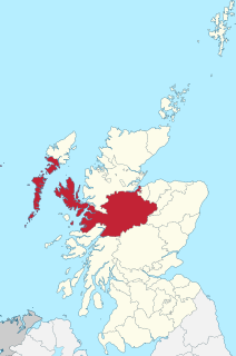
Argyll, sometimes called Argyllshire, is a historic county and registration county of western Scotland.

Loch Fyne, is a sea loch off the Firth of Clyde and forms part of the coast of the Cowal peninsula. Located on the west coast of Argyll and Bute, Scotland. It extends 65 kilometres (40 mi) inland from the Sound of Bute, making it the longest of the sea lochs in Scotland. It is connected to the Sound of Jura by the Crinan Canal. Although there is no evidence that grapes have grown there, the title is probably honorific, indicating that the river, Abhainn Fìne, was a well-respected river.
Crinan is a name of Gaelic origin and it has a number of contexts:

Crinan is a small village located on the west coast of Scotland in the region known as Knapdale, which is part of Argyll and Bute. Before the Crinan Canal was built, Crinan was named Port Righ which meant the king's port. The canal was named from the small settlement of Crinan Ferry on the edge of Loch Crinan where a small ferry landed. The name Crinan probably derives from the Creones tribe who lived in the area in 140 AD. The canal starts at Ardrishaig sea loch on Loch Gilp, and ends nine miles away at Crinan sea loch on the Sound of Jura. The canal was designed to provide a short cut between the west coast and islands at one end and the Clyde estuary at the other, and so avoid the long voyage around the south end of the Kintyre Peninsula.

The Clyde puffer is a type of small coal-fired and single-masted cargo ship, built mainly on the Forth and Clyde canal, and which provided a vital supply link around the west coast and Hebrides of Scotland.

The Sound of Jura is a strait in Argyll and Bute, Scotland. It is one of the several Sounds of Scotland.

Cairnbaan is a village situated on the Crinan Canal, in Argyll and Bute, western Scotland.

Loch Gilp is a small inlet on Loch Fyne which gives its name to Lochgilphead. The Crinan Canal extends from the loch across to Crinan itself.
National Cycle Route 78 runs from Campbeltown to Inverness. It was officially launched as the Caledonia Way in 2016 as part of the wider redevelopment of Scotland's cycle network. It runs from the Kintyre peninsula to the Great Glen and the route varies from on road to traffic-free forest trails and canal paths.

Loch Ness is a large freshwater loch in the Scottish Highlands extending for approximately 37 kilometres southwest of Inverness. It takes its name from the River Ness, which flows from the northern end. Loch Ness is best known for alleged sightings of the cryptozoological Loch Ness Monster, also known affectionately as "Nessie". It is one of a series of interconnected, murky bodies of water in Scotland; its water visibility is exceptionally low due to a high peat content in the surrounding soil. The southern end connects to Loch Oich by the River Oich and a section of the Caledonian Canal. The northern end connects to Loch Dochfour via the River Ness, which then ultimately leads to the North Sea via the Moray Firth.
Inverness-shire is a historic county, registration county and lieutenancy area of Scotland. Covering much of the Highlands and Outer Hebrides, it is Scotland's largest county, though one of the smallest in population, with 67,733 people or 1.34% of the Scottish population.

Loch Craignish is a sea loch on the mid-Argyll coast.

Scottish Canals is the public corporation of the Scottish Government responsible for managing the country's inland waterways. Formerly a division of British Waterways, it became a stand-alone public body of the Scottish Government on 2 July 2012. Legally, the corporation is still referred to as the British Waterways Board, but in all other aspects it uses the brand Scottish Canals.

Loch A' Bharain is an impounding reservoir which sits directly on the north bank of the Crinan Canal beside lock No.9, 1.5 kilometres (0.93 mi) west of Cairnbaan, and is one of a number of reservoirs supplying water to the canal. The earthfill dam is 5.6 metres (18 ft) high and was constructed in 1801 during the construction of the Crinan Canal, works were completed by 1810 and after further repair and inspection by 1815 - 1820 the Crinan canal helped bring jobs and industry to the area shortening what would be a longer voyage on boat to get to Crinan and other areas on the west coast, the 9 mile canal became a Royal Route when Queen Victoria sailed the canal after works completed, this was part of her tour of Scotland, Loch á Bharain is one of the many many Lochs (lakes) and burns (rivers) feeding the Crinan Canal, when the Crinan Canal was drained for repair and inspection, Loch á Bharain was drained quite a lot which revealed not just old lock gates, tyres and other bits and pieces but this big drainage discovered a rocky foundation which is the remains of the old castle of Clan McTavish . Today this area is still a popular place for water sports, activities and sailing, it’s also a tourist hub and famous destination as a scheduled monument. There is also timber industries in the area, Fir Tree. Plantations are visible everywhere. The Dalriada Heritage trail that starts at the Loch and head up north to Carnasserie castle is a long but scenic trail that takes you back in time to view old woodlands and along the way is the cairns and ancient artefacts at the famous Kilmartin Glen and Kilmartin Museum, then heading up to Carnasserie Castle, built after the vikings, is still in tact with multiple stories constructed with stone, the main walls and floors are still up with some parts fallen off at the top and with no roof but a nice view. The Castle is protected by Historic Scotland And classified as a scheduled monument just like Kilmartin Glen and Loch á Bharain

Eilean dà Mhèinn, is a small inhabited island in Loch Crinan and one of the Inner Hebrides of Scotland.

