Sound of Jura

Last updated

Sound of Jura
An Linne Rosach (Scottish Gaelic)
Dubh Sgeir The sound of Jura.jpg
Small group of skerries in the Sound of Jura, looking Northwest towards Jura
Scotland relief location map.jpg
Red pog.svg
Sound of Jura
LocationWestern Scotland
Coordinates 55°58′50″N5°45′20″W / 55.98056°N 5.75556°W / 55.98056; -5.75556
Type Sound
FrozenNo

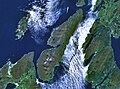
The Sound of Jura (Scottish Gaelic : An Linne Rosach) is a Sound in Argyll and Bute, Scotland. It is one of the several Sounds of Scotland. It is to the east of the island of Jura and the west of Knapdale, in the north of the Kintyre Peninsula, of the Scottish mainland. Lochs that lead to the sound include Loch Sween, and Loch Killisport (Caolisport (Scottish Gaelic)). It is not to be confused with the Sound of Islay, which lies between Jura and Islay. Most of Jura's small population lives on the east coast, overlooking the sound.

Contents

Gulf of Corryvreckan

The Gulf of Corryvreckan, which contains a notorious whirlpool, the world's third largest, located at the north of the Sound. [1]

Crinan Canal

The Crinan Canal's west exit is also on the Sound of Jura. The canal is a shorter route from Loch Fyne, than sailing round the Mull of Kintyre. [2]

Lighthouses

Ruadh Sgeir Lighthouse

The Ruadh Sgeir Lighthouse, built in 1906, by David A and Charles Stevenson. It is a category C listed structure (LB52575). Located at grid reference NR 72141 92628 . [3]

Skervuile Lighthouse

The Skervuile Lighthouse, was completed in 1865, built by David and Thomas Stevenson. Located at grid reference NR 6045 7129 , at the entrance to Lowlandman’s Bay. [4] [5]

George Orwell

Intermittently between 1946 and 1949, George Orwell (Eric Arthur Blair (25 June 1903 – 21 January 1950)), stayed in Barnhill, a farmhouse on the northeast of the island overlooking the Sound, while he completed his novel Nineteen Eighty-Four . [6]

Related Research Articles

<span class="mw-page-title-main">Argyll and Bute</span> Council area of Scotland

Argyll and Bute is one of 32 unitary council areas in Scotland and a lieutenancy area. The current lord-lieutenant for Argyll and Bute is Jane Margaret MacLeod. The administrative centre for the council area is in Lochgilphead at Kilmory Castle, a 19th-century Gothic Revival building and estate. The current council leader is Councillor Jim Lynch.

<span class="mw-page-title-main">Inner Hebrides</span> Archipelago off the west coast of mainland Scotland

The Inner Hebrides is an archipelago off the west coast of mainland Scotland, to the south east of the Outer Hebrides. Together these two island chains form the Hebrides, which experience a mild oceanic climate. The Inner Hebrides comprise 35 inhabited islands as well as 44 uninhabited islands with an area greater than 30 hectares. Skye, Mull, and Islay are the three largest, and also have the highest populations. The main commercial activities are tourism, crofting, fishing and whisky distilling. In modern times the Inner Hebrides have formed part of two separate local government jurisdictions, one to the north and the other to the south. Together, the islands have an area of about 4,130 km2 (1,594 sq mi), and had a population of 18,948 in 2011. The population density is therefore about 4.6 inhabitants per square kilometre.

<span class="mw-page-title-main">Argyll</span> Historic county and registration county of western Scotland

Argyll, sometimes called Argyllshire, is a historic county and registration county of western Scotland.

<span class="mw-page-title-main">Gigha</span> Island in Scotland

Gigha or the Isle of Gigha is an island off the west coast of Kintyre in Scotland. The island forms part of Argyll and Bute and has a population of 163 people. The climate is mild with higher than average sunshine hours and the soils are fertile. The main settlement is Ardminish.

<span class="mw-page-title-main">Scarba</span>

Scarba is an island, in Argyll and Bute, Scotland, just north of the much larger island of Jura. The island has not been permanently inhabited since the 1960s. Until his death in 2013 it was owned by Richard Hill, 7th Baron Sandys; its owner now is Shane Cadzow who farms Luing cattle on the nearby island of Luing and grazes some of the cattle on Scarba. Kilmory Lodge is used seasonally as a shooting lodge, the island having a flourishing herd of red deer.

<span class="mw-page-title-main">Belnahua</span>

Belnahua is one of the Slate Islands, in the Firth of Lorn in Scotland, known for its deserted slate quarries. The bedrock that underpins its human history is part of the Scarba Conglomerate Formation and its value has been on record since the 16th century. Likely uninhabited before commercial quarrying commenced, under the control of the Stevenson family during the 19th century the population expanded to over 150 before the island was abandoned again in 1914.

<span class="mw-page-title-main">Knapdale</span> Parishes and area in Scotland

Knapdale forms a rural district of Argyll and Bute in the Scottish Highlands, adjoining Kintyre to the south, and divided from the rest of Argyll to the north by the Crinan Canal. It includes two parishes, North Knapdale and South Knapdale. The area is bounded by sea to the east and west, whilst the sea loch of West Loch Tarbert almost completely cuts off the area from Kintyre to the south. The name is derived from two Gaelic elements: Cnap meaning hill and Dall meaning field.

<span class="mw-page-title-main">Loch Fyne</span> Sea inlet on west coast of Scotland

Loch Fyne, is a sea loch off the Firth of Clyde and forms part of the coast of the Cowal Peninsula. Located on the west coast of Argyll and Bute, west of Scotland. It extends 65 kilometres (40 mi) inland from the Sound of Bute, making it the longest of the sea lochs in Scotland. It is connected to the Sound of Jura by the Crinan Canal. Although there is no evidence that grapes have grown there, the title is probably honorific, indicating that the river, Abhainn Fìne, was a well-respected river.

<span class="mw-page-title-main">Crinan, Argyll</span> Village in Argyll and Bute, Scotland

Crinan is a small village located on the west coast of Scotland in the region known as Knapdale, which is part of Argyll and Bute. Before the Crinan Canal was built, Crinan was named Port Righ which meant the king's port. The canal was named from the small settlement of Crinan Ferry on the edge of Loch Crinan where a small ferry landed. The name Crinan probably derives from the Creones tribe who lived in the area in 140 AD. The canal starts at Ardrishaig sea loch on Loch Gilp, and ends nine miles away at Crinan sea loch on the Sound of Jura. The canal was designed to provide a short cut between the west coast and islands at one end and the Clyde estuary at the other, and so avoid the long voyage around the south end of the Kintyre Peninsula.

<span class="mw-page-title-main">Gulf of Corryvreckan</span> A narrow strait off the coast of Scotland

The Gulf of Corryvreckan, also called the Strait of Corryvreckan, is a narrow strait between the islands of Jura and Scarba, in Argyll and Bute, off the west coast of mainland Scotland.

<span class="mw-page-title-main">Port Askaig</span> Human settlement in Scotland

Port Askaig is a port village on the east coast of the island of Islay, in Scotland. The village lies on the Sound of Islay across from Jura.

Lunga is one of the Slate Islands in the Firth of Lorn in Argyll and Bute, Scotland. The "Grey Dog" tidal race, which runs in the sea channel to the south, reaches 8 knots (15 km/h) in full flood. The name "Lunga" is derived from the Old Norse for "isle of the longships', but almost all other place names are Gaelic in origin.

<span class="mw-page-title-main">Finlaggan</span>

Finlaggan is a historic site on Eilean Mòr in Loch Finlaggan. The Loch, the island, and Finlaggan Castle lie on Islay, around two kilometres to the northwest of Ballygrant.

<span class="mw-page-title-main">Jura, Scotland</span> Island of the Inner Hebrides off Great Britain

Jura is an island in the Inner Hebrides of Scotland, adjacent to and northeast of Islay. With an area of 36,692 hectares (142 sq mi), and 196 inhabitants recorded in the 2011 census, Jura is more sparsely populated than Islay, and is one of the least densely populated islands of Scotland: in a list of the islands of Scotland ranked by size, Jura comes eighth, whereas by population it comes 31st. The island is mountainous, bare and largely infertile, covered by extensive areas of blanket bog.

<span class="mw-page-title-main">Islay</span> Island of the Inner Hebrides of Scotland

Islay is the southernmost island of the Inner Hebrides of Scotland. Known as "The Queen of the Hebrides", it lies in Argyll and Bute just south west of Jura and around 40 kilometres north of the Northern Irish coast. The island's capital is Bowmore where the distinctive round Kilarrow Parish Church and a distillery are located. Port Ellen is the main port.

<span class="mw-page-title-main">Sound of Islay</span> Sound

The Sound of Islay is a narrow strait between the islands of Islay and Jura off the west coast of Scotland. It is about 30 kilometres in extent from north to south and lies between Rubh' a' Mhàil on Islay and Rubh' Aird na Sgitheich on Jura to the north and Macarthur's Head and Rubha na Tràille to the south. The islands in the Sound are Am Fraoch Eilean, Brosdale Island and Glas Eilean, all of which are off the south east coast of Jura. These islands, Jura south of Loch Tarbert and the eastern part of the Sound are one of 40 National Scenic Areas in Scotland.

References

  1. "The Corryvreckan Whirlpool – Scotland's maelstrom".
  2. "Crinan Canal Skipper's Guide". Scottish Canals.
  3. "Ruadh Sgeir Lighthouse, Ruadh Sgeir, Sound of Jura (LB52575)". portal.historicenvironment.scot.
  4. "Jura, Skervuile Lighthouse | Canmore". canmore.org.uk.
  5. "Skervuile". Northern Lighthouse Board.
  6. "1984: How did the Isle ofJura shape George Orwell's masterpiece?". BBC News. 7 June 2024.


Purge