
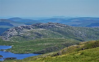
The Merrick, or simply Merrick, is a mountain in the Range of the Awful Hand, a sub-range of the Galloway Hills range, part of the Southern Uplands of Scotland. The summit elevation is 843 metres, making it the highest mountain in the Southern Uplands and southern Scotland.

The Southern Uplands are the southernmost and least populous of mainland Scotland's three major geographic areas. The term is used both to describe the geographical region and to collectively denote the various ranges of hills and mountains within this region. An overwhelmingly rural and agricultural region, the Southern Uplands are partly forested and contain many areas of open moorland - the hill names in the area are congruent with these characteristics.

Broad Law is a hill in the Manor Hills range, part of the Southern Uplands of Scotland. The second-highest point in the Southern Uplands and the highest point in the Scottish Borders, it has an elevation of 840 metres, a prominence of 653 metres and an isolation of 81 kilometres. It is only 3 m (10 ft) lower than its parent, Merrick. Like many of its neighbours it is smooth, rounded and grassy, although the surrounding glens have very steep sides — country somewhat akin to the Cheviots or the Howgill Fells. The hill is most easily climbed from the Megget Stane to the south, beginning at an elevation of 452 m (1,483 ft), but is also frequently climbed from the villages near its base, or as part of a long, 50 km (30 mi) trek across the local area between the towns of Peebles and Moffat. On the summit is the highest VOR beacon in the UK, and also a radio tower.

The Range of the Awful Hand is a range of hills in the Galloway Hills range, part of the Southern Uplands of Scotland. The most westerly of three parallel ridges, the range is neighboured to the east by the Dungeon Hills and the Rhinns of Kells. The Minnigaff Hills also lie southeast. In total, these four ranges are part of the Galloway Forest Park. The ridge is split between South Ayrshire and Dumfries and Galloway.
Craignaw is a hill in the Dungeon Hills, a sub-range of the Galloway Hills range, part of the Southern Uplands of Scotland. Unlike many hills in the Southern Uplands, Craignaw has a complex and rocky summit area, with a long line of crags and rough ground on the east side. The hill is largely composed of granite. Near the north end of the hill is an interesting area of terrain known as the "Deil's Bowlin' Green" where various rounded granite boulders are scatterd at random over an area of nearly horizontal granite slabs. These are believed to be glacial erratics or result from a similar glacier process. On the west side of the hill, near grid reference NX458831, a few hundred meters from the summit is an F-111E Aardvark crash site. The site is marked by a small memorial to the two U.S. Air Force pilots who were killed in the accident. Although the crash happened on 19 December 1979 there are still small amounts of aircraft debris in the area.

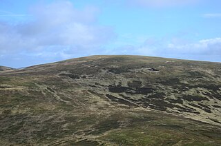
White Coomb is a hill in the Moffat Hills range, part of the Southern Uplands of Scotland. Its broad summit is the highest point in the range and the registration county of Dumfriesshire, as well as being the fourth highest point in southern Scotland, however, despite this, it is largely concealed by other hills on all sides except its east and south east, making this the only direction from which its full scale can be seen.

The Moffat Hills are a range of hills in the Southern Uplands of Scotland. They form a roughly triangular shape with a west facing side, a north facing side, and a south-east facing side. It is 17 kilometres from east to west across this triangle and some 16 kilometres north to south. The highest point is White Coomb at 821 m (2694 ft). The town of Moffat lies just south of the Moffat hills and along with Tweedsmuir, at the northern extremity, is the only centre of population around these hills. In some older maps, the northern part of the Moffat Hills is called the Tweedsmuir Hills, but can also be known by the title Manor Hills.

Mullwharchar is a hill in the Dungeon Hills, a sub-range of the Galloway Hills range, part of the Southern Uplands of Scotland. Mullwarchar is situated to the north of Loch Enoch, west of Corserine, northeast of Merrick and east of Kirriereoch Hill. There are 3 cliffs on the mountain named The Slock, The Tauchers and The Organ Pipes and some routes on these are occasionally climbed. Mullwharchar's summit is fairly flat and dotted with erratics.

Ettrick Pen is a hill in the Ettrick Hills range, part of the Southern Uplands of Scotland. A remote peak, It lies southwest of the village of Ettrick, on the border of the Scottish Borders and Dumfries and Galloway. The highest of the Ettrick Hills, it is crossed by the Southern Upland Way and is a prominent landmark from many directions. Its summit is topped by an ancient cairn.

Gathersnow Hill is a hill in the Culter Hills range, part of the Southern Uplands of Scotland. It lies west of the village of Tweedsmuir on the border of the Scottish Borders and South Lanarkshire. The second highest of the Culter Hills after Culter Fell to the north, the two Grahams are often climbed together.

Windlestraw Law is a hill in the Moorfoot Hills range, part of the Southern Uplands of Scotland. It is the highest peak of the range, and lies north of the town of Innerleithen in the Scottish Borders. A large and boggy peak, it is usually climbed from either its western slopes or the longer route from Tweeddale to the south.
Cramalt Craig is a hill in the Manor Hills range, part of the Southern Uplands of Scotland. The second highest in the range and third highest in southern Scotland, it was previously also a Corbett until a 2013 survey by Alan Dawson found the col between it and Broad Law to be a few metres short of 500 feet. It is climbed almost solely from its southern sides at the Megget Stane or Cramalt Farm, taking in the neighbouring hills.

Milldown is a hill in the Rhinns of Kells, a sub-range of the Galloway Hills range, part of the Southern Uplands of Scotland. It is located immediately north of Meikle Millyea - between these two hills lie the Lochans of Auchniebut, a series of small water bodies at an approximate elevation of 650m - possibly the highest permanent water bodies in the Southern Uplands. As well as this, the hill is also flanked on its SW side by forest plantation - possibly the highest planted commercial forestry in the Southern Uplands. Like most of its neighbours, it is most easily climbed from the east at Forrest Lodge.
The Manor Hills, also known as the Tweedsmuir Hills, are a range of hills south of Peebles in the Scottish Borders, one of the ranges which collectively form the Southern Uplands. They are separated from the Moffat Hills by the Talla Reservoir, Megget Reservoir and St. Mary's Loch, the Moorfoot Hills by the A72 and the Culter Hills in South Lanarkshire by the A701. The western portion of the hills are designated as the 'Tweedsmuir Hills' Site of Special Scientific Interest and the 'Upper Tweeddale' National Scenic Area, with the major tributary rivers designated as Special Areas of Conservation.

Wind Fell is a hill in the Ettrick Hills range, part of the Southern Uplands of Scotland. The Dumfries and Galloway-Scottish Borders border lies across the hill. Close to the Southern Upland Way, routes of ascent frequently incorporate its track and it is almost always climbed along with the neighbouring hills.

Cauldcleuch Head is a hill in an unnamed range of Roxburghshire hills north of Langholm, part of the Southern Uplands of Scotland. The highest hill in this range, it has an isolation of approximately 26 km. Parts of the Gorrenberry Jubilee Wood can be found in the Billhope glen to its southwest, where the easiest line of ascent is found.
The Dungeon Hills are a range of hills in the Galloway Hills range, part of the Southern Uplands of Scotland. The central of three parallel ridges, they are neighboured by the Range of the Awful Hand to the west and the Rhinns of Kells to the east. The range is also perpendicular to the Minnigaff Hills range, immediately south. In total, these four ranges are part of the Galloway Forest Park.

The Rhinns of Kells are a range of hills in the Galloway Hills range, part of the Southern Uplands of Scotland. The most easterly of three parallel ridges, they are neighboured to the west by the Range of the Awful Hand and the Dungeon Hills. The eastern portion of the Minnigaff Hills range lies immediately southwest of the range. In total, these four ranges are part of the Galloway Forest Park. The ridge is located entirely within Dumfries and Galloway, with the base of the western flanks being a northwestern boundary of the county.

The Culter Hills, Coulter Fells or variations thereof, are a range of hills, part of the Southern Uplands of Scotland. They are neighboured to the east by the Manor Hills and are split roughly in half by the border between South Lanarkshire and the Scottish Borders.

The Ettrick Hills are a range of hills that are part of the Southern Uplands of Scotland. They are neighboured to the northwest by the Moffat Hills and are located mainly within the Scottish Borders; however, the Dumfries and Galloway border covers the south and southwesterly flanks.
