
Victoria is the capital city of the Canadian province of British Columbia, on the southern tip of Vancouver Island off Canada's Pacific coast. The city has a population of 91,867, and the Greater Victoria area has a population of 397,237. The city of Victoria is the seventh most densely populated city in Canada with 4,406 inhabitants per square kilometre (11,410/sq mi).

The Trans-Canada Highway is a transcontinental federal–provincial highway system that travels through all ten provinces of Canada, from the Pacific Ocean on the west coast to the Atlantic Ocean on the east coast. The main route spans 7,476 km (4,645 mi) across the country, one of the longest routes of its type in the world. The highway system is recognizable by its distinctive white-on-green maple leaf route markers, although there are small variations in the markers in some provinces.

The Trans Canada Trail, officially named the Great Trail between September 2016 and June 2021, is a cross-Canada system of greenways, waterways, and roadways that stretches from the Atlantic to the Pacific to the Arctic oceans. The trail extends over 24,000 km (15,000 mi); it is now the longest recreational, multi-use trail network in the world. The idea for the trail began in 1992, shortly after the Canada 125 celebrations. Since then it has been supported by donations from individuals, corporations, foundations, and all levels of government.

The Kettle Valley Railway was a subsidiary of the Canadian Pacific Railway (CPR) that operated across southern British Columbia, west of Midway running to Rock Creek, then north to Myra Canyon, down to Penticton over to Princeton, Coalmont, Brookmere, Coquihalla and finally Hope where it connected to the main CPR line.
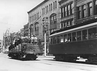
The British Columbia Electric Railway (BCER) was an historic railway which operated in southwestern British Columbia, Canada. Originally the parent company for, and later a division of, BC Electric Company, the BCER assumed control of existing streetcar and interurban lines in southwestern British Columbia in 1897, and operated the electric railway systems in the region until the last interurban service was discontinued in 1958. During and after the streetcar era, BC Electric also ran bus and trolleybus systems in Greater Vancouver and bus service in Greater Victoria; these systems subsequently became part of BC Transit, and the routes in Greater Vancouver eventually came under the control of TransLink. Trolley buses still run in the City of Vancouver with one line extending into Burnaby.
Pacific Highway is the name of several north–south highways in the Pacific Coast region of the Western United States, either by legislation officially designating it as such or by common usage.
Highway 1 is a provincial highway in British Columbia, Canada, that carries the main route of the Trans-Canada Highway (TCH). The highway is 1,047 kilometres (651 mi) long and connects Vancouver Island, the Greater Vancouver region in the Lower Mainland, and the Interior. It is the westernmost portion of the main TCH to be numbered "Highway 1", which continues through Western Canada and extends to the Manitoba–Ontario boundary. The section of Highway 1 in the Lower Mainland is the second-busiest freeway in Canada, after Ontario Highway 401 in Toronto.
Highway 17 is a provincial highway in British Columbia, Canada. It comprises two separate sections connected by a ferry link. The Vancouver Island section is known as the Patricia Bay Highway and connects Victoria to the Swartz Bay ferry terminal in North Saanich. The Lower Mainland section is known as the South Fraser Perimeter Road and connects the Tsawwassen ferry terminal to Delta and Surrey, terminating at an interchange with Highway 1 in the Fraser Valley.
Highway 11, known locally as the Abbotsford–Mission Highway, is a 17 km (11 mi) long at-grade expressway that figuratively cuts the Fraser Valley in half. The highway was first given the '11' designation in 1958, and it originally followed South Fraser Way through Abbotsford, being re-routed onto the four-lane Sumas Way in the mid-1980s. Highway 11 originally entered Mission over the same bridge that carries a spur of the Canadian Pacific Railway across the Fraser River, but it was re-routed onto its own bridge, the Mission Bridge, in 1973.

The Island Corridor, previously the Esquimalt & Nanaimo Railway, is a railway operation on Vancouver Island. It is owned by the Island Corridor Foundation, a registered charity. The railway line is 225 kilometres (140 mi) in length from Victoria to Courtenay, known as the Victoria Subdivision, with a branch line from Parksville to Port Alberni, known as the Port Alberni Subdivision, of 64 kilometres (40 mi), for a total 289 kilometres (180 mi) of mainline track. In 2006, the Island Corridor Foundation acquired the railway's ownership from RailAmerica and Canadian Pacific Railway.
The Comox Valley is a region on the east coast of Vancouver Island, British Columbia, Canada, that includes the city of Courtenay, the town of Comox, the village of Cumberland, and the unincorporated settlements of Royston, Union Bay, Fanny Bay, Black Creek, and Merville. The communities of Denman Island and Hornby Island are also considered part of the Comox Valley. The Comox Valley contains the 47th largest metropolitan area in Canada with a population of about 76,000 as of 2022.
Alberta Provincial Highway No. 16, commonly referred to as Highway 16, is a major east–west highway in central Alberta, Canada, connecting Jasper to Lloydminster via Edmonton. It forms a portion of the Yellowhead Highway, a major interprovincial route of the Trans-Canada Highway system that stretches from Masset, British Columbia, to Portage la Prairie, Manitoba, near Winnipeg. Highway 16 spans approximately 634 km (394 mi) from Alberta's border with British Columbia in the west to its border with Saskatchewan in the east. As of 2010, all but less than 96 km (60 mi) of the route was divided, with a minimum of two lanes in each direction. It is designated a core route in Canada's National Highway System.

The Galloping Goose Regional Trail is a 55-kilometre (34 mi) rail trail between Victoria, British Columbia, Canada, and the ghost town of Leechtown, north of Sooke, where it meets the old Sooke Flowline. Maintained by the Capital Regional District (CRD), the trail forms part of the Trans-Canada Trail, and intersects the Lochside Regional Trail. The section from Harbour Road in Esquimalt to the Veterans Memorial Parkway in Langford is also part of the Vancouver Island Trail.

The Carlton Trail was the primary land transportation route in the Canadian Northwest for most of the 19th century, connecting Fort Carlton to Edmonton along a line of intermediate places. It was part of a trail network that stretched from the Red River Colony through Fort Ellice and today's Fort Qu'Appelle, Saskatchewan. From there the trail ran north and crossed the South Saskatchewan River near Batoche, Saskatchewan and reached Fort Carlton on the North Saskatchewan River. From there, it ran west on the north side of the river to Fort Edmonton at what is now Edmonton, Alberta.
The Old Cariboo Road is a reference to the original wagon road to the Cariboo gold fields in what is now the Canadian province of British Columbia. It should not be confused with the Cariboo Road, which was built slightly later and used a different route.

Swartz Bay is a 22.7 ha (56.1-acre) ferry terminal and a major transportation facility at Swartz Bay in North Saanich, British Columbia. It is located 32 km (20 mi) north of Victoria on Vancouver Island. The terminal is part of the BC Ferries system, as well as part of Highway 17.
The Victoria and Sidney Railway Company (V&S) was one of three railways to operate on the Saanich Peninsula of southern Vancouver Island, British Columbia. Opened in 1894 the route largely closed in 1919 but a section of track remained in use until 1935.
The E&N Rail Trail is a 17 km (11 mi) paved bike and pedestrian trail designed to be a non-motorized recreation and commuter connection to downtown Victoria, British Columbia, Canada and runs through Esquimalt, View Royal, and Langford. The E&N Rail Trail was also designed to connect with existing popular trail systems such as the Galloping Goose Regional Trail or Lochside Regional Trails. The trail lays alongside a suspended yet active rail line. The trail is named for SVI's predecessor Esquimalt and Nanaimo Railway.

