Lock and Dam No. 26 (historical)

Last updated
Lock and Dam No. 26
Mississippi River old Lock and Dam number 26.jpg
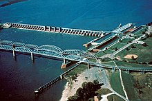
Old Lock and Dam 26 and the Old Clark Bridge with a swing span rail bridge in between.
CountryUSA
LocationAlton, Illinois
Coordinates 38°53′10″N90°10′55″W / 38.88611°N 90.18194°W / 38.88611; -90.18194
StatusDecommissioned
Construction began1939
Demolition date1990
Dam and spillways
ImpoundsUpper Mississippi River
Length600 ft

Lock and Dam No. 26 was a lock and dam located near Alton, Illinois on the Upper Mississippi River around river mile 202.5.

Opened in 1938, its largest lock was 600 feet long. It was demolished in 1990 and replaced by the Melvin Price Locks and Dam, which is also known as Lock and Dam number 26.

See also

38°53′10″N90°10′55″W / 38.88611°N 90.18194°W / 38.88611; -90.18194


Related Research Articles

<span class="mw-page-title-main">Mississippi River</span> Major river in the United States

The Mississippi River is the primary river, and second-longest river, of the largest drainage basin in the United States. From its traditional source of Lake Itasca in northern Minnesota, it flows generally south for 2,340 miles (3,766 km) to the Mississippi River Delta in the Gulf of Mexico. With its many tributaries, the Mississippi's watershed drains all or parts of 32 U.S. states and two Canadian provinces between the Rocky and Appalachian mountains. The main stem is entirely within the United States; the total drainage basin is 1,151,000 sq mi (2,980,000 km2), of which only about one percent is in Canada. The Mississippi ranks as the thirteenth-largest river by discharge in the world. The river either borders or passes through the states of Minnesota, Wisconsin, Iowa, Illinois, Missouri, Kentucky, Tennessee, Arkansas, Mississippi, and Louisiana.

<span class="mw-page-title-main">Godfrey, Illinois</span> Village in Illinois, United States

Godfrey is a village in Madison County, Illinois, United States. The population was 17,825 at the 2020 census. Godfrey is located within the River Bend portion of the Greater St. Louis metropolitan area.

<span class="mw-page-title-main">Fulton, Illinois</span> Place in Illinois, United States

Fulton is a city in Whiteside County, Illinois, United States. The population was 3,481 at the 2010 census, down from 3,881 in 2000. Fulton is located across the Mississippi River from Clinton, Iowa.

<span class="mw-page-title-main">Saint Anthony Falls</span> Waterfall in Mississippi River into the Mississippi River Gorge in Minneapolis, Minnesota

Saint Anthony Falls, or the Falls of Saint Anthony located at the northeastern edge of downtown Minneapolis, Minnesota, is the only natural major waterfall on the Mississippi River. Throughout the mid-to-late 1800’s, various dams were built atop the east and west faces of the falls to support the milling industry that spurred the growth of the city of Minneapolis. In 1880, the central face of the falls was reinforced with a sloping timber apron to stop the upstream erosion of the falls. In the 1950s, the apron was rebuilt with concrete, which makes up the most visible portion of the falls today. A series of locks were constructed in the 1950s and 1960s to extend navigation to points upstream.

<span class="mw-page-title-main">Tombigbee River</span> River in Alabama and Mississippi, United States

The Tombigbee River is a tributary of the Mobile River, approximately 200 mi (325 km) long, in the U.S. states of Mississippi and Alabama. Together with the Alabama, it merges to form the short Mobile River before the latter empties into Mobile Bay on the Gulf of Mexico. The Tombigbee watershed encompasses much of the rural coastal plain of western Alabama and northeastern Mississippi, flowing generally southward. The river provides one of the principal routes of commercial navigation in the southern United States, as it is navigable along much of its length through locks and connected in its upper reaches to the Tennessee River via the Tennessee-Tombigbee Waterway.

<span class="mw-page-title-main">Meeker Island Lock and Dam</span> United States historic place

The Meeker Island Lock and Dam was the first lock and dam facility built on the Upper Mississippi River. Meeker Island was named after its owner Judge Bradley B. Meeker. Meeker County was named after him also. After a construction period lasting eight years, the site was only in operation for five years from 1907 to 1912 when the growing interest in hydroelectric power led to design and construction of today's Lock and Dam No. 1 a few miles downriver. It was realized that the new dam could take over the function provided by this first site and another small dam a short distance downriver.

<span class="mw-page-title-main">Keokuk Rail Bridge</span> Bridge across the Mississippi river

The Keokuk Bridge, also known as the Keokuk Municipal Bridge, is a double-deck, single-track railway and highway bridge across the Mississippi River in the United States between Keokuk, Iowa, and Hamilton, Illinois, just downstream of Mississippi Lock and Dam number 19. It was designed by Ralph Modjeski and constructed 1915–1916 on the piers of its predecessor that was constructed in 1869–1871.

<span class="mw-page-title-main">Black River (Wisconsin)</span> River

The Black River is a river in west-central Wisconsin and tributary of the Mississippi River. The river is approximately 190 miles (310 km) long. During the 19th century, pine logs were rafted down the Black, heading for sawmills at La Crosse and points beyond.

<span class="mw-page-title-main">Lock and Dam No. 1</span> Dam in Minnesota, United States.

Ford Dam, officially known as Lock and Dam No. 1, is on the Upper Mississippi River and is located between Minneapolis and Saint Paul, Minnesota just north of the confluence of the Mississippi with the Minnesota River at Mississippi River mile 847.9, in Minneapolis. The powerhouse portion was previously owned by the Ford Motor Company, which operated a hydroelectric power station to feed electricity to its Twin Cities Assembly Plant on the east side of the river. It was sold to Brookfield Power Co. in April 2008. The dual-lock facility and dam was built and is operated by the St. Paul district of the U.S. Army Corps of Engineers' Mississippi Valley Division.

<span class="mw-page-title-main">Old Clark Bridge</span> Former Illinois/Missouri Mississippi River crossing

The Old Clark Bridge was a bridge that carried U.S. Route 67 across the Mississippi River between West Alton, Missouri and Alton, Illinois. It was constructed beginning in 1927, was replaced by the Clark Bridge and was demolished in 1994. The bridge was initially a toll bridge.

<span class="mw-page-title-main">Lock and Dam No. 7</span> Dam in near La Crescent, Minnesota

Lock and Dam No. 7 is a lock and dam located on the Upper Mississippi River at river mile 702.5 near the cities of La Crescent, Minnesota and Onalaska, Wisconsin. It forms pool 7 and Lake Onalaska. The facility was constructed in the mid-1930s and placed in operation on April, 1937. It underwent major rehabilitation from 1989 through 2002. The lock and dam are owned and operated by the St. Paul District of the United States Army Corps of Engineers-Mississippi Valley Division.

<span class="mw-page-title-main">Lock and Dam No. 11</span> Dam in Grant County, Wisconsin

General Zebulon Pike Lock and Dam No. 11 is a lock and dam located between Dubuque, Iowa, and rural Grant County, Wisconsin, on the Upper Mississippi River.

<span class="mw-page-title-main">Lock and Dam No. 15</span> Dam in Illinois / Davenport, Iowa

Lock and Dam No. 15 is a lock and dam located on the Upper Mississippi River. It spans the river between Rock Island, Illinois and Davenport, Iowa. Lock and Dam 15 is the largest roller dam in the world, its dam is 1,203 feet (366.7 m) long and consists of nine 109 feet (33.2 m) non-submersible, non-overflow roller gates and two 109 feet (33.2 m) non-submersible overflow roller gates. It is unusual among the upper Mississippi River dams in that it has only roller gates, has different sizes and types of roller gates, it is not perpendicular to the flow of the river and is one of the few facilities that has a completed auxiliary lock. The main lock is 110 feet (33.5 m) wide by 600 feet (180 m) long and its auxiliary lock is 110 feet (34 m) wide by 360 feet (110 m) long. In 2004, the facility was listed in the National Register of Historic Places as Lock and Dam No. 15 Historic District, #04000175 covering 3,590 acres (1,450 ha), 2 buildings, 9 structures, and 1 object.

<span class="mw-page-title-main">Lock and Dam No. 19</span> Dam in Illinois / Keokuk, Iowa

Lock and Dam No. 19 is a lock and dam located on the Upper Mississippi River near Keokuk, Iowa. In 1978, the Keokuk Lock and Dam was listed in the National Register of Historic Places, #78001234. In 2004, the facility was listed in the National Register of Historic Places as Lock and Dam No. 19 Historic District, #04000179 covering 1,605 acres (650 ha), 7 buildings, 12 structures, 1 object. The lock is owned and operated by the U.S. Army Corps of Engineers. The dam is owned and operated by Ameren Missouri.

<span class="mw-page-title-main">Chouteau Island</span>

Chouteau Island, situated approximately eight miles (13 km) due north of the Gateway Arch in St. Louis, Missouri, and approximately one mile (1.6 km) south of the confluence of the Missouri River and Mississippi River, is one of a cluster of three islands: Chouteau Island, Gabaret Island, and Mosenthein Island. The three, with a combined area of approximately 5,500 acres (20 km2), are located in Madison County, Illinois.

The Confluence Trail, part of the Madison County, Illinois Transit (MCT) bikeways network, is a 20.5 miles (33.0 km) bike trail between Granite City and Alton, Illinois's Russell Commons Park. The majority of the trail is paved asphalt on top of the Mississippi River levee system. The trail is part of the St. Louis metro area's Confluence Greenway.

<span class="mw-page-title-main">Savanna Army Depot</span>

Savanna Army Depot was a 13,062-acre (52.86 km2) installation, located on the eastern bank of the Mississippi River, in Carroll and Jo Daviess counties, around seven miles (11 km) north of Savanna, Illinois. It was opened in 1917 as a proving and testing facility for weapons developed at Rock Island Arsenal. In 1921 it became a weapons depot. The U.S. Environmental Protection Agency (EPA) listed the depot as a Superfund site in 1989. The depot was selected for closure through the Base Realignment and Closure process in July 1995 and was officially closed on March 18, 2000. The Jo-Carroll Local Redevelopment Authority (LRA) was established to redevelop a portion of the property for commercial and business usage referred to as the Savanna Depot Park. On September 26, 2003, the United States Department of Defense agreed to transfer 9,404 acres (38.06 km2) of land to become the Lost Mound Unit of the Upper Mississippi River National Wildlife and Fish Refuge. 3,022 acres (12.23 km2) were initially transferred with the rest to be transferred following environmental cleanup. The portion near Lock and Dam No. 12 was transferred to the United States Army Corps of Engineers and a small part to the Illinois Department of Natural Resources.

<span class="mw-page-title-main">Alton Bridge</span> Former railroad bridge across the Mississippi River

The Alton Bridge was a railroad bridge that carried the Chicago, Burlington, and Quincy across the Mississippi River between West Alton, Missouri, and Alton, Illinois. It was located 100 yards (91 m) upriver from, and parallel to, the Old Clark Bridge. The bridge was built between 1892 and 1894 and was removed shortly after the line was abandoned in 1988. With a total length of 2,060 feet (630 m), it consisted of eight through-truss segments—six Pratt trusses, one Pennsylvania truss, and one pivot-swinging truss.