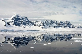
The Trojan Range is a mountain range rising to 2,760 metres (9,055 ft), extending northward from Mount Francais along the east side of Iliad Glacier, Anvers Island, in the Palmer Archipelago of the British Antarctic Territory. It was surveyed by the Falkland Islands Dependencies Survey (FIDS) in 1955 and named by the UK Antarctic Place-Names Committee (UK-APC) for the Trojans, one of the opposing sides in the Trojan War in Homer's Iliad.
Access Point is a rocky point immediately southeast of Biscoe Point and 2 miles (3 km) northwest of Cape Lancaster on the south side of Anvers Island, in the Palmer Archipelago. First charted by the French Antarctic Expedition under Jean-Baptiste Charcot, 1903–05. Surveyed in 1955 by the Falkland Islands Dependencies Survey (FIDS) and so named because there is a landing place for boats on the northwest tip of the point which provides access to the inland parts of the island.

Aphrodite Glacier is a glacier 15 nautical miles (28 km) long flowing north to the east coast of the Antarctic Peninsula 3 nautical miles (6 km) west of Victory Nunatak.

Bevin Glacier is a glacier 5 nautical miles (9 km) long, which flows east from the plateau escarpment on the east side of Graham Land into the northwest end of Cabinet Inlet between Attlee Glacier and Anderson Glacier. During December 1947 it was charted by the Falkland Islands Dependencies Survey (FIDS) and photographed from the air by the Ronne Antarctic Research Expedition. It was named by the FIDS for Rt. Hon. Ernest Bevin, M.P., British Minister of Labour and National Service and member of the War Cabinet.
Billie Peak is a peak, 725 metres (2,380 ft) high, which rises 1.5 nautical miles (3 km) east-northeast of Bay Point on the southeast coast of Anvers Island, in the Palmer Archipelago. It was discovered by the Belgian Antarctic Expedition, 1897–99, under Gerlache. The name appears on a chart based on a 1927 Discovery Investigations survey, but may reflect an earlier naming.
Breakwater Island is a small island in the Palmer Archipelago with a line of rocks extending in a southwest arc from it, lying opposite Nipple Peak, 0.3 nautical miles (0.6 km) off the east side of Wiencke Island. The descriptive name, suggestive of an artificial breakwater, was given by the Falkland Islands Dependencies Survey in 1944.
Brown Island in the Antarctic is a small, brown, almost snow-free island in the southeastern part of the Wauwermans Islands, 2 nautical miles (4 km) southwest of Wednesday Island, in the Wilhelm Archipelago. It was charted by the British Graham Land Expedition under John Rymill, 1934–37, and so named because its brown color distinguished it from adjacent snow-capped islands.

Cadman Glacier is a glacier, 1.5 nautical miles (3 km) wide at its mouth and about 7 nautical miles (13 km) long, flowing northwestward into the head of the southern arm of Beascochea Bay south of Plas Point on the west side of the Antarctic Peninsula.

Channel Glacier is a through glacier, 1.5 nautical miles (3 km), extending in an east-west direction across Wiencke Island, between Nipple Peak and Wall Range, in the Palmer Archipelago. It was discovered by the Belgian Antarctic Expedition under Gerlache 1897–99. The name appears on a chart based on a 1927 survey by DI personnel on the Discovery.
Vittoria Buttress is a conspicuous rock cliff, rising to about 750 m, overlooking the southeast side of Lazarev Bay and forming the northwest extremity of the Lassus Mountains in northern Alexander Island, Antarctica. The feature was first mapped from air photographs taken by the Ronne Antarctic Research Expedition in 1947–48, by Searle of the Falkland Islands Dependencies Survey in 1960. Named by the United Kingdom Antarctic Place-Names Committee for Tomas Luis de Victoria (1535–1611), Spanish composer.

Perrier Bay is a bay 6 nautical miles (11 km) wide indenting the northwest coast of Anvers Island in the Palmer Archipelago, Antarctica between Obitel Peninsula and Goten Peninsula. It is entered north of Giard Point and south of Quinton Point. Masteyra Island is lying in the north part of the bay, and Trebishte Island and Vromos Island in its south part.

Montgolfier Glacier is a glacier situated between Rozier Glacier and Woodbury Glacier and flowing between Balis Ridge and Bacho Kiro Peak into Piccard Cove on the west coast of Graham Land, Antarctica.
Gould Glacier is a glacier, 12 miles (19 km) long, on the east coast of Graham Land, Antarctica, flowing south-east into Mill Inlet, to the west of Aagaard Glacier. It was first surveyed by the Falklands Islands Dependencies Survey in 1946–47, and named "East Gould Glacier". Together with "West Gould Glacier" it was reported to fill a transverse depression across Graham Land, but further survey in 1957 showed that there is no close topographical alignment between the two. The name Gould Glacier, after Rupert T. Gould, a British polar historian and cartographer, is now only applied to this glacier, and the west glacier is now called Erskine Glacier.

Mikkelsen Harbor is a small bay indenting the south side of Trinity Island between Skottsberg Point and Borge Point, in the Palmer Archipelago, Antarctica. It was discovered by the Swedish Antarctic Expedition, 1901–04. The origin of the name comes from Peder Michelsen, whaling manager who was lost in the whaling grounds in December 1910. The harbour was charted by Captain Hans Borge, and apparently the name was in common usage by 1913, at the time of the geologic reconnaissance by Scottish geologist David Ferguson in the whale-catcher Hanka..
Harris Peak is a peak, 1,005 metres (3,300 ft) high, surmounting the base of Reclus Peninsula on the west coast of Graham Land, Antarctica. It was mapped by the Falkland Islands Dependencies Survey (FIDS) from photos taken by Hunting Aerosurveys Ltd in 1956–57, and was named by the UK Antarctic Place-Names Committee in 1960 for Leslie Harris, a FIDS carpenter and general assistant at the Danco Island station in 1956, who participated in the reconnaissance journeys from that station and from the nearby Portal Point hut.
Hartshorne Island is an island between Dakers Island and Howard Island in the eastern Joubin Islands, Antarctica. It was named by the Advisory Committee on Antarctic Names for Sidney G. Hartshorne, Master of RV Hero on her first Antarctic voyage to Palmer Station in 1968.
Heed Rock is a very small rock, awash at high water and virtually hidden from sight, lying 1 nautical mile (2 km) south of Brown Island in the Wauwermans Islands in the Wilhelm Archipelago, Antarctica. It was shown on an Argentine government chart of 1950, but not named. It was surveyed by the British Naval Hydrographic Survey Unit in 1956–57, and so named by the UK Antarctic Place-Names Committee as a caution to mariners.

Howarth Glacier is a small glacier flowing south-southeast to Admiralty Sound along the west side of The Watchtower, in southeastern James Ross Island, Antarctica. It was named by the UK Antarctic Place-Names Committee in 1995 after Michael Kingsley Howarth, Deputy Keeper of Paleontology at the British Museum, 1980–92, and author of the Falkland Islands Dependencies Survey Scientific Report Number 21, Alexander Island.
Cape Lachman is a cape marking the northern tip of James Ross Island, which lies south of Trinity Peninsula, Antarctica. It was discovered by the Swedish Antarctic Expedition, 1901–04, under Otto Nordenskiöld, who named it for J. Lachman, a patron of the expedition.
Howard Island is an island directly south of Hartshorne Island in eastern Joubin Islands, at the south-western end of the Palmer Archipelago of Antarctica. It was named by the US Advisory Committee on Antarctic Names (US-ACAN) for Judson R. Howard, mate in the RV Hero on her first voyage to Palmer Station in 1968.


