
Georgetown County is a county located in the U.S. state of South Carolina. As of the 2020 census, the population was 63,404. Its county seat is Georgetown. The county was founded in 1769. It is named for George III of the United Kingdom.

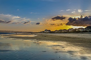
Holden Beach is a seaside town in Brunswick County, North Carolina. The population was 575 at the time of the 2010 census. It is part of the Wilmington, NC Metropolitan Statistical Area.

Ocean Isle Beach is a small seaside town in Brunswick County, North Carolina, United States. It was incorporated as a town in 1959 and is part of the Wilmington, NC Metropolitan Statistical Area. The population was 867 at the 2020 census. Located at the southern end of North Carolina's Atlantic coastline, along the Atlantic Intracoastal Waterway, Ocean Isle Beach has private homes, seasonal rentals, and tourist attractions.

The Intracoastal Waterway (ICW) is a 3,000-mile (4,800 km) inland waterway along the Atlantic and Gulf of Mexico coasts of the United States, running from Massachusetts southward along the Atlantic Seaboard and around the southern tip of Florida, then following the Gulf Coast to Brownsville, Texas. Some sections of the waterway consist of natural inlets, saltwater rivers, bays, and sounds, while others are artificial canals. It provides a navigable route along its length without many of the hazards of travel on the open sea.

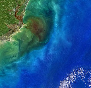
The Cape Fear River is a 191.08-mile-long blackwater river in east-central North Carolina. It flows into the Atlantic Ocean near Cape Fear, from which it takes its name. The river is formed at the confluence of the Haw River and the Deep River in the town of Moncure, North Carolina. Its river basin is the largest in the state: 9,149 sq mi.
The Little River flows through Little River, South Carolina, briefly touching the border with North Carolina before emptying into the Atlantic Ocean at the Little River Inlet. A large portion of the river forms part of the Atlantic Intracoastal Waterway. Due to USGS weather buoy off Little River Inlet, the Little River Inlet is often referred to in weather forecasts.
Jupiter Island is a barrier island on the coast of Martin and Palm Beach counties, Florida. It is bounded on the east by the Atlantic Ocean, on the north by the St. Lucie Inlet, on the west by the Indian River, and on the south by the Jupiter Inlet. Jupiter Island originally was two islands, Long Island on the north and Jupiter Island on the south, which were once separated by an inlet in the vicinity of North Jupiter Narrows and what is officially called Peck Lake, but commonly called Peck's Lake.
Oak Island is located on the Atlantic Ocean coast in Brunswick County, North Carolina near the South Carolina border. A barrier island, it contains the towns of Oak Island and Caswell Beach, Fort Caswell and the Oak Island Coast Guard Station which is co-located with the Oak Island Lighthouse. Almost 13 miles long, the island averages about one mile wide. As of 2020 the island had 8,791 permanent residents, while the summertime population can swell to nearly 50,000.
The Canaveral Barge Canal is an active canal in Brevard County, Florida, cutting east-west across northern Merritt Island just south of Cape Canaveral. It connects the Atlantic Ocean and Port Canaveral with the Indian River and wider Indian River Lagoon, part of the Intracoastal Waterway. The canal consists of two segments separated by the Banana River.

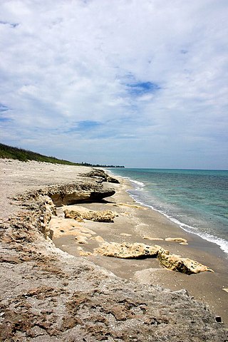
The Outer Banks are a 200 mi (320 km) string of barrier islands and spits off the coast of North Carolina and southeastern Virginia, on the east coast of the United States. They line most of the North Carolina coastline, separating Currituck Sound, Albemarle Sound, and Pamlico Sound from the Atlantic Ocean. A major tourist destination, the Outer Banks are known for their wide expanse of open beachfront and Cape Hatteras National Seashore. The seashore and surrounding ecosystem are important biodiversity zones, including beach grasses and shrubland that help maintain the form of the land.
Winyah Bay is a coastal estuary that is the confluence of the Waccamaw River, the Pee Dee River, the Black River, and the Sampit River in Georgetown County, in eastern South Carolina. Its name comes from the Winyah people, who inhabited the region during the eighteenth century. The historic port city of Georgetown is located on the bay, and the bay generally serves as the terminating point for the Grand Strand.

The Lumber River, sometimes referred to as the Lumbee River, is a 133-mile-long (214 km) river in south-central North Carolina in the flat Coastal Plain. European settlers first called the river Drowning Creek, which is still used as the name of its headwater. The waterway known as the Lumber River extends downstream from the Scotland County-Hoke County border to the North Carolina-South Carolina border. Soon after crossing into South Carolina, the Lumber River flows into the Little Pee Dee River, which flows into the Pee Dee River, or Great Pee Dee River. Finally, the combined waters flow into Winyah Bay and the Atlantic Ocean.

In North Carolina, the Crystal Coast is an 85-mile stretch of coastline that extends from the Cape Lookout National Seashore, which includes 56 miles of protected beaches, southwestward to the New River. The Crystal Coast is a popular area with tourists and second-home owners in the summer, with a name coined by the Carteret County Tourism Development Authority.

Figure Eight Island is a barrier island in the U.S. state of North Carolina, just north of Wrightsville Beach, widely known as an affluent summer colony and vacation destination. The island is part of the Wilmington Metropolitan Area, and lies between the Intracoastal Waterway and the Atlantic Ocean. As a private island, Figure Eight can only be reached by boat or via a guarded causeway swing bridge—the only private bridge over the Intracoastal Waterway in the American Southeast.

Supply is a small unincorporated community in Brunswick County, North Carolina, United States, located around the intersection of US 17 and NC 211. Its name is derived from the use of the Lockwoods Folly River as a trade route in the 18th and 19th centuries. Residents of the nearby beach communities of Holden Beach, Oak Island, Ocean Isle, Caswell Beach, and Sunset Beach often formerly commuted to Supply for goods and other materials. This practice is still common, but development in the town of Southport and in the Intracoastal Waterway commercial districts has made traveling to Supply unnecessary.
Cape Fear is a coastal plain and Tidewater region of North Carolina centered about the city of Wilmington. The region takes its name from the adjacent Cape Fear headland, as does the Cape Fear River which flows through the region and empties into the Atlantic Ocean near the cape. Much of the region's populated areas are found along the Atlantic beaches and the Atlantic Intracoastal Waterway, while the rural areas are dominated by farms and swampland like that of the Green Swamp. The general area can be also identified by the titles "Lower Cape Fear", "Wilmington, NC Metropolitan Statistical Area", "Southeastern North Carolina", and "Azalea Coast". The latter name is derived from the North Carolina Azalea Festival held annually in Wilmington. Municipalities in the area belong to the Cape Fear Council of Governments.

Pleasure Island is a coastal barrier island in Southeastern North Carolina, United States, just south of the City of Wilmington. Pleasure Island is located within Federal Point Township, in New Hanover County. The coastal resort towns of Carolina Beach and Kure Beach, as well as the annexed communities of Wilmington Beach and Hanby Beach are located on the island. The southern end of Pleasure Island was separated from Bald Head Island by Corncake Inlet until the inlet was shoaled and closed in 1998 by Hurricane Bonnie; thus Pleasure Island and Bald Head Island are no longer separate islands.

Sunset Harbor is an unincorporated community on the banks of the Lockwood Folly River and the Atlantic Intracoastal Waterway in Brunswick County, North Carolina, United States. It is bordered by the city limits of Oak Island and is situated across the river from Varnamtown. By road, the community can only be accessed by Sunset Harbor Road, which feeds into North Carolina Highway 211.
The Shallotte River is a tidal river in Brunswick County, North Carolina, United States.
Hewletts Creek is a stream in New Hanover County, North Carolina, in the United States. It is the only stream of its name in the United States.

