
White County is a county located in the U.S. state of Arkansas. As of the 2020 census, the population was 76,822. The county seat is Searcy. White County is Arkansas's 31st county, formed on October 23, 1835, from portions of Independence, Jackson, and Pulaski counties and named for Hugh Lawson White, a Whig candidate for President of the United States. It is an alcohol prohibition or dry county, though a few private establishments can serve alcohol.
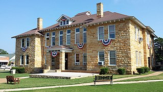
Stone County is located in the Ozark Mountains in the U.S. state of Arkansas. The county is named for rugged, rocky area terrain of the Ozarks. Created as Arkansas's 74th county on April 21, 1873, Stone County has two incorporated cities: Mountain View, the county seat and most populous city, and Fifty-Six. The county is also the site of numerous unincorporated communities and ghost towns.

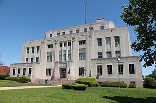
Randolph County is located between the Ozark Mountains and Arkansas Delta in the U.S. state of Arkansas. The county is named for John Randolph, a U.S. senator from Virginia influential in obtaining congressional approval of the Louisiana Purchase, which includes today's Randolph County. Created as Arkansas's 32nd county on October 29, 1835, Randolph County has two incorporated cities, including Pocahontas, the county seat and most populous city. The county is also the site of numerous unincorporated communities and ghost towns.
Miller County is a county located in the southwestern corner of the U.S. state of Arkansas. As of the 2020 census, the population was 42,600. The county seat is Texarkana.
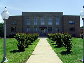
Lincoln County is located between the Arkansas Timberlands and Arkansas Delta in the U.S. state of Arkansas. It is also within the Pine Bluff metro area, and on the outer edge of the Central Arkansas region. The county is named for President Abraham Lincoln. Created as Arkansas's 65th county on March 28, 1871, Lincoln County has three incorporated cities, including Star City, the county seat and most populous city. The county contains 46 unincorporated communities and ghost towns, Cane Creek State Park at the confluence of Cane Creek and Bayou Bartholomew, and nine listings on the National Register of Historic Places to preserve the history and culture of the county.

Hot Spring County is located in the U.S. state of Arkansas. As of the 2020 census, the population was 33,040. The county seat is Malvern. Hot Spring County was formed on November 2, 1829, from a portion of Clark County. It was named for the hot springs at Hot Springs, Arkansas, which were within its boundaries until Garland County was formed in 1873.

Arkansas County is a county located in the U.S. state of Arkansas. As of the 2020 census, the population was 17,149. Located in the Arkansas Delta, the county has two county seats, DeWitt and Stuttgart.

Stuttgart is a city in and the county seat of the northern district of Arkansas County, Arkansas, United States. Established by German settlers, it was named for its larger German counterpart. Known as the "Rice and Duck Capital of the World", the city is an international destination for waterfowl hunting along the Mississippi Flyway. Stuttgart is the most important city on the Arkansas Grand Prairie, a region known for rice cultivation. The economy is largely based on agricultural production, waterfowl tourism, and supporting industries. As of the 2010 census it had a population of 9,326.
Scotland is an unincorporated community in southwestern Van Buren County, Arkansas, United States, near the head of the South Fork of the Little Red River. In April 2010, a tornado struck this community which resulted in extreme damage.
DeWitt School District No. 1 is a school district based in the town of DeWitt, Arkansas, United States. The DeWitt School District is geographically the state's largest school district with 872.29 square miles (2,259.2 km2) of land and 46.18 square miles (119.6 km2) of water, encompassing portions of Arkansas and Jefferson, and Desha counties.
Stuttgart High School is a public secondary school for students in grades 7 through 12 located in Stuttgart, Arkansas. The high school is administered by the Stuttgart Public Schools. It is located at the intersection of 22nd Street and Buerkle Road.
Stuttgart Public Schools is the public school district for students of primary and secondary education in the Stuttgart, Arkansas and surrounding areas.
Wiseman is a small unincorporated community situated along the Strawberry River in the northeast corner of Izard County, Arkansas, United States.
Crocketts Bluff is an unincorporated community in Arkansas County, Arkansas, United States. It is the location of Crocketts Bluff Hunting Lodge, which is located at the end of the dirt road north of the point at which AR 153 turns south, and is listed on the National Register of Historic Places. Crocketts Bluff sits at an elevation of 171 feet the highest point in Arkansas County. The ZIP Code for Crocketts Bluff is 72038.

Bayou Meto is an unincorporated community in Arkansas County, Arkansas, United States. The community is located where Arkansas Highway 276S diverges from Arkansas Highway 276.
Casscoe is an unincorporated community in Arkansas County, Arkansas, United States. The community is located where Arkansas Highway 33 Spur diverges from Arkansas Highway 33.
Cleveland is an unincorporated community in Conway County, Arkansas, United States. Cleveland is located on Arkansas Highway 95, 19 miles (31 km) north of Morrilton. Cleveland has a post office with ZIP code 72030. Cleveland was founded in 1890, named after former President Grover Cleveland.
Sweden is an unincorporated community in Jefferson County, Arkansas, United States. Sweden is located on Arkansas Highway 88, 16.1 miles (25.9 km) east of Pine Bluff. On January 22, 2012, an EF2 tornado struck Sweden, damaging grain bins and metal buildings; the tornado continued to a point northeast of Lodge Corner in Arkansas County.
DeWitt High School is a comprehensive public high school located in DeWitt, Arkansas, United States. The school provides secondary education for students in grades 9 through 12. DeWitt is one of two public high schools in Arkansas County, Arkansas and the sole high school administered by the DeWitt School District.

Highway 276 is a designation for two state highways in Arkansas County, Arkansas. One route is a short industrial access road in south Stuttgart. A second route begins at US Highway 165 (US 165) at Lodge Corner and runs 16.17 miles (26.02 km) to US 165/AR 1/AR 152 south of De Witt. A spur route, designated Highway 267S, runs south at Bayou Meto to connect to Highway 11. All three routes are maintained by the Arkansas Department of Transportation (ArDOT).


