
Oxfordshire is a landlocked county in South East England. The ceremonial county borders Warwickshire to the north-west, Northamptonshire to the north-east, Buckinghamshire to the east, Berkshire to the south, Wiltshire to the south-west and Gloucestershire to the west.

Hertford Bridge, often called "the Bridge of Sighs", is a skyway joining two parts of Hertford College over New College Lane in Oxford, England. Its distinctive design makes it a city landmark.

The Radcliffe Quadrangle is the second quadrangle of University College, Oxford, England. The buildings have been Grade I listed since 1954.

South Stoke is a village and civil parish on an east bank of the Thames, about 1.5 miles (2.4 km) north of Goring-on-Thames in South Oxfordshire. It includes less than 1 mile (1.6 km) to its north the hamlet and manor house of Littlestoke.

The High Street in Oxford, England, known locally as the High, runs between Carfax, generally seen as the centre of the city, and Magdalen Bridge to the east.
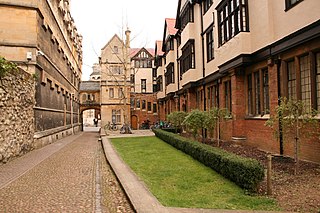
Logic Lane is a small historic cobbled lane that runs through University College in Oxford, England, so called because it was the location of a school of logicians. It links the High Street at the front of the college with Merton Street to the rear, which is also cobbled. Logic Lane covered bridge is a short covered bridge over the lane at the High Street end. To the west of the lane are the Radcliffe Quad and the Master's Lodgings. To the east are the 1903 Durham Buildings and the Goodhart Quad. The lane is locked at night, with gates at each end. It is mainly used by pedestrians, but vehicular access is possible.

Alfred Street is a street running between the High Street to the north and the junction with Blue Boar Street and Bear Lane at the southern end, in central Oxford, England. To the south is Christ Church, one of Oxford University's historic colleges.

New College Lane is a historic street in central Oxford, England, named after New College, one of the older Oxford colleges, adjacent to the north.

Catte Street is a historic street in central Oxford, England.
Kingston Road is a road in Oxford, England. It continues north from Walton Street, at the junction with Walton Well Road to the west and St Bernard's Road to the east, running parallel with and to the west of Woodstock Road. Kingston Road is the main road in Walton Manor. At the northern end, there is a staggered junction with Aristotle Lane to the west and Polstead Road to the east. The road continues as Hayfield Road. Southmoor Road and Southmoor Place lead off Kingston Road to the west.

Brasenose Lane runs east-west in central Oxford, England, between Radcliffe Square and Turl Street. It is accessible only to pedestrians at its west end, but vehicles can enter from Radcliffe Square. The lane retains the medieval pattern of a single drainage channel in its centre and has high stone-faced college buildings on each side, being flanked by three historic Oxford colleges.
Harry Wilkinson Moore, FRIBA (1850–1915) was a Victorian and Edwardian architect. He was the son of Arthur Moore (1814–1873) and Mary Wilkinson (1821–1904), and a nephew of the architects George Wilkinson and William Wilkinson.
Pullens Lane is in Headington, east Oxford, England. It is located at the top of Headington Hill, leading north off Headington Road to Jack Straw's Lane and Harberton Mead. The cul-de-sac Pullens Field leads off west from Pullens Lane.

Milham Ford School was a girl's secondary school in Oxford, England, located in the suburb of New Marston on Marston Road.
St Cross Church is a former church, now a historic collections centre, in Oxford, England, to the northeast of the centre of the city. The church is on St Cross Road at the junction with Manor Road, just south of Holywell Manor. Also close by is Holywell Cemetery.

The Church of St Peter-le-Bailey is a church on New Inn Hall Street in central Oxford, England. It was formerly next to Bonn Square, which was originally the churchyard. Now it is located halfway up New Inn Hall Street to the north. Several churches have existed on or close to the site. The current church is now the chapel of St Peter's College, Oxford.

New Road is a street in west central Oxford, England. It links Park End Street and Worcester Street to the west with Queen Street and Castle Street to the east. To the south is Oxford Castle and the former Oxford Prison, now a Malmaison hotel. To the north is Nuffield College, a graduate college of Oxford University. At the eastern end on the south side is New County Hall, the headquarters of Oxfordshire County Council.

Brewer Street is a historic narrow street in central Oxford, England, south of Carfax. The street runs east-west, connecting with St Aldate's to the east and St Ebbe's Street to the west.
Rewley Road is in the west of central Oxford, England. It is located in St Thomas's parish.

The Holywell Music Room is the city of Oxford's chamber music hall, situated on Holywell Street in the city centre, within the grounds of Wadham College. It is said to be the oldest purpose-built music room in Europe, and hence Britain's first concert hall.


