
The United States Minor Outlying Islands is a statistical designation defined by the International Organization for Standardization's ISO 3166-1 code. The entry code is ISO 3166-2:UM. The minor outlying islands and groups of islands comprise eight United States insular areas in the Pacific Ocean and one in the Caribbean Sea.
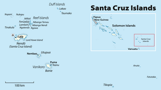
The Santa Cruz Islands form an archipelago in Temotu Province, Solomon Islands. They lie approximately 250 miles to the southeast of the Solomon Islands archipelago, just north of the archipelago of Vanuatu and are considered part of the Vanuatu rain forests ecoregion. The term Santa Cruz Islands is sometimes used to encompass all the islands of Temotu Province, Solomon Islands.
The Duff Islands are a small island group lying to the northeast of the Santa Cruz Islands in province of Temotu Province, in the nation of Solomon Islands. They are also sometimes known as the Wilson Islands.

The Reef Islands are a loose collection of 16 islands in the in Temotu Province, in the independent nation of Solomon Islands. These islands have historically also been known by the names of Swallow Islands and Matema Islands.

Western Province is the largest of the nine provinces of Solomon Islands. The area is renowned for its beautiful tropical islands, excellent diving and snorkelling, coral reefs and World War II wrecks, ecotourism lodges, and head-hunting shrines. The province contains many small lagoons and most of the country's tourist trade outside Honiara.

Temotu is the easternmost province of Solomon Islands. The province was formerly known as Santa Cruz Islands Province. It consists, essentially, of two chains of islands which run parallel to each other from the northwest to the southeast. Its area is 895 square kilometres.

Taro Island is a small island in Solomon Islands with 507 inhabitants. It is the capital of Choiseul Province and is located in Choiseul Bay off the northwest coast.

Roncador Reef is a reef in Solomon Islands, south of Ontong Java Atoll and north of Santa Isabel Island.

Nukapu is one of the islands of the nation of Solomon Islands. It is in the Reef Islands group in Temotu Province; the easternmost province of the Solomons. The estimated terrain elevation above sea level is 15 metres.
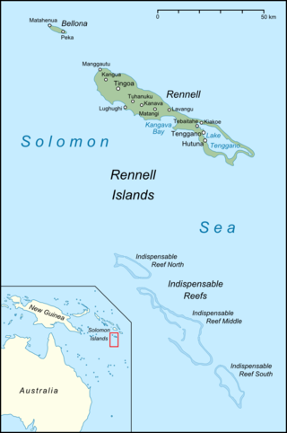
The Indispensable Reefs are a chain of three large coral atolls in the Coral Sea. They are located about 50 km (30 mi) south of Rennell Island. The chain stretches over a length of 114 km (71 mi) and its average width is 18 km (11 mi).
Nifiloli is an island in the Reef Islands, in Temotu Province, in the independent nation of Solomon Islands. The estimated terrain elevation above sea level is 19 metres. Despite its location in Melanesia, the population of the islands is Polynesian.
Fenualoa is the second largest island in the Reef Islands, in Temotu Province, in the nation of Solomon Islands.

Makalom is a small uninhabited island in the Reef Islands, in Temotu Province, in the nation of Solomon Islands. The island is 350 m long and 60 m wide, and is located on the south-west side of an oval-shaped atoll 2.5 km long and 1.5 km wide, some 4.8 km WNW of Pileni Island.

Uepi is an island in Western Province, in the independent nation of Solomon Islands. It is noted for its high quality blue-water drop-off scuba diving.
Lomlom is the largest of the Reef Islands in Temotu Province, in the nation of Solomon Islands. It measures seven by four kilometres and separated from Fenualoa by a deep channel. The estimated terrain elevation above sea level is some 21 metres. Variant forms of the island's name are Fonofono and Lom lom.
Matema Island or Matema is of one of the Reef Islands in Temotu Province, of the independent nation of Solomon Islands.
Fera Island is one of the chain of islands forming Buala Bay, in Isabel Province, Solomon Islands. The other islands are Juakau, Tasia, Karuo and Sulei.
Ngalo is of one of the Reef Islands located in Temotu Province, in the independent nation of Solomon Islands.
Ngatendo is of one of the Reef Islands in Temotu Province, in the independent nation of Solomon Islands. The island is inhabited.

The Coral reefs of Solomon Islands consists of six major islands and over 986 smaller islands, in Oceania, to the east of Papua New Guinea and northwest of Vanuatu. Solomon Islands lie between latitudes 5° and 13°S, and longitudes 155° and 169°E. The distance between the westernmost and easternmost islands is about 1,500 km (930 mi). The Santa Cruz Islands are situated north of Vanuatu and are especially isolated at more than 200 km (120 mi) from the other islands. The Solomon Islands has the 22nd largest Exclusive Economic Zone of 1,589,477 km2 (613,701 sq mi) of the Pacific Ocean.
