The gull-billed tern, formerly Sterna nilotica, is a tern in the family Laridae. It is now considered to be in its own genus. The genus name is from Ancient Greek gelao, "to laugh", and khelidon, "swallow". The specific niloticus is from Latin and means of the Nile.
Carlingford Lough is a glacial fjord or sea inlet that forms part of the border between Northern Ireland to the north and the Republic of Ireland to the south. On its northern shore is County Down and on its southern shore is County Louth. At its extreme interior angle it is fed by the Newry River and the Newry Canal.

Cemlyn Bay is a bay on the northwest coast of Anglesey, North Wales, approximately 2.5 km west of Wylfa nuclear power station, within the community of Cylch-y-Garn.
Ynys Feurig is the name for a set of three small inter-connected low-lying inshore tidal rocky islets, lying off from the west coast of Anglesey, North Wales, just north of the village of Rhosneigr and south of RAF Valley airfield. They are also known by the English name Starvation Island. The islets are accessible from the mainland at mid-to low tide. The clipper Norman Court ran aground nearby, in Cymyran Bay.
Cape Hooker is the south-eastern point of Low Island, in the South Shetland Islands of Antarctica. The feature was roughly charted by nineteenth century sealers; it was further charted by Commander Henry Foster in 1829 but shown as the north-eastern point of the island. Following air photography by the Falkland Islands and Dependencies Aerial Survey Expedition in 1956, the charted shape of the island was drastically altered and the name Cape Hooker was applied to its south-eastern point as originally described.
The Twin Islands are similarly shaped Arctic islands in the Qikiqtaaluk Region of Nunavut, Canada. They are located in central James Bay, 56 km (35 mi) north east of Akimiski Island, and 58 km (36 mi) west of Quebec. The group includes North Twin and South Twin islands.

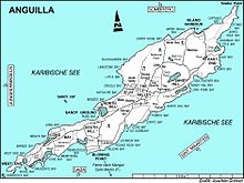
The Prickly Pear Cays, sometimes spelled Prickley Pear Cays, are a small pair of uninhabited islands about six miles from Road Bay, Anguilla, in the Leeward Islands of the Caribbean. They are divided by a narrow boat channel between Prickly Pear East and Prickly Pear West. Prickly Pear Cays were classified as 'wildlands' by the "Eastern Caribbean Natural Area Management Programme" (ECNAMP). In addition, Prickly Pear Cays are one of six marine protected areas of Anguilla.
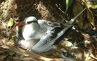
The South-west Saint Helena Important Bird Area is a 45 km2 tract of land covering about 37% of the island of Saint Helena, a British Overseas Territory in the South Atlantic Ocean. It has been identified by BirdLife International as an Important Bird Area (IBA) because it supports several colonies of breeding seabirds, including the red-billed tropicbird, as well as habitat of the endemic, and critically endangered, Saint Helena plover.

Cove Pond is a shallow 287 ha wetland at the south-western end of the Caribbean island of Anguilla, a British Overseas Territory. It forms part of a larger coastal lagoon from which it is separated by a causeway constructed for access to the Cap Juluca resort.
Grey Pond is a 191 ha shallow, brackish lagoon at the eastern end of the main island of Anguilla, a British Overseas Territory in the Caribbean. Its southern and eastern shores are relatively steep-sided limestone slopes, while its north-eastern corner is separated from Savannah Bay by a belt of sand dunes. The limestone shores are covered by low, scrub vegetation.
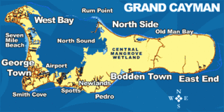
The Central Manrove Wetland is a large area of mangrove dominated wetland on Grand Cayman, one of the Cayman Islands, a British Overseas Territory in the Caribbean Sea. It is one of the territory’s Important Bird Areas (IBAs).

The Crown Wetlands lie on Little Cayman, one of the Cayman Islands, a British Overseas Territory in the Caribbean Sea. Collectively they form one of the territory’s Important Bird Areas (IBAs).
Road Salt Pond, also known as Road Bay Pond or simply Road Pond, is a wetland in Anguilla, a British Overseas Territory in the Caribbean Sea. It is one of the territory’s Important Bird Areas (IBAs).
Cauls Pond is a wetland in Anguilla, a British Overseas Territory in the Caribbean Sea. It is one of the territory’s Important Bird Areas (IBAs).
West End Pond is a wetland in Anguilla, a British Overseas Territory in the Caribbean Sea. It is one of the territory’s Important Bird Areas (IBAs).
Rendezvous Bay Pond, also known as Rendezvous Bay Salt Pond, is a wetland in Anguilla, a British Overseas Territory in the Caribbean Sea. It is one of the territory’s Important Bird Areas (IBAs).
Meads Bay Pond is a wetland in Anguilla, a British Overseas Territory in the Caribbean Sea. It is one of the territory’s Important Bird Areas (IBAs).
The Merrywing Pond System is a golf course wetland system in Anguilla, a British Overseas Territory in the Caribbean Sea. It forms one of the territory’s Important Bird Areas (IBAs).
Forest Bay Pond is a small wetland in Anguilla, a British Overseas Territory in the Caribbean Sea. It forms one of the territory’s Important Bird Areas (IBAs).

The Fish Ponds and Crossing Place Trail Important Bird Area is a 1024 ha tract of land on the island of Middle Caicos in the Turks and Caicos Islands, a British Overseas Territory in the Lucayan Archipelago of the western Atlantic Ocean. It forms one of the territory’s Important Bird Areas (IBAs).