Long Wharf (Portland, Maine)

Last updated
Long Wharf
Long Wharf 2024.jpg
Long Wharf (right), looking southwest to Chandler's Wharf
Location Commercial Street, Portland, Maine, U.S.

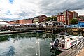
Long Wharf is a historic wharf in Portland, Maine, on the edge of the Fore River. It stands across Commercial Street, between Market Street and Moulton Street and, on the waterfront side, between Portland Pier (to the north) and Chandler's Wharf (to the south). [1] [2] [3]

Portland Lobster Company stands at the foot of the wharf, at Commercial Street, while DiMillo's On the Water is a floating restaurant located on a boat moored at the wharf. [4] [5] Sections of the former Berlin Wall stands on the southern side of the wharf, near today's Gorham Savings Bank. [6]

Related Research Articles

<span class="mw-page-title-main">Portland Pier</span>

Portland Pier is located at the intersection of Commercial Street and Silver Street on the eastern waterfront in Portland, Maine. It is located between Custom House Wharf and Long Wharf, on the edge of the Fore River.

The Portland Fish Pier is a fishing pier located in Portland, Maine, on the edge of the Fore River. It is a major hub for the commercial fishing industry, and is home to the Portland Fish Exchange, where over 20 million pounds (9.1 kt) of seafood a year are bought and sold. A fishermen's memorial is also located at the pier.

<span class="mw-page-title-main">Old Port of Portland, Maine</span> Historic district in the U.S.

The Old Port is a district of Portland, Maine, known for its cobblestone streets, 19th-century brick buildings and fishing piers. The district contains boutiques, restaurants and bars. Because of its reputation for nightlife, the Old Port is a popular destination for tourists and locals alike.

<span class="mw-page-title-main">Commercial Street, Portland, Maine</span> Street in Portland, Maine, United States

Commercial Street is a downtown street in the Old Port of Portland, Maine, United States. It is part of U.S. Route 1A. It became the Old Port's waterfront in the early 20th century, replacing Fore Street, after land was reclaimed from the waters of Casco Bay and the Fore River.

<span class="mw-page-title-main">Maine Wharf</span> Historic wharf in Portland, Maine, U.S.

MaineWharf is a historic wharf in Portland, Maine. It is located on Commercial Street, between Franklin Street and Pearl Street, on the edge of the Fore River. On the waterfront side, it is situated between Maine State Pier and Custom House Wharf.

<span class="mw-page-title-main">Custom House Wharf</span> Historic wharf in Portland, Maine, U.S.

Custom HouseWharf is a historic wharf in Portland, Maine, on the edge of the Fore River. Named for Portland's United States Custom House, which stands across Commercial Street from the wharf, on Pearl Street, the wharf is located between Maine Wharf and Portland Pier.

<span class="mw-page-title-main">Chandler's Wharf</span> Historic wharf in Portland, Maine, U.S.

Chandler's Wharf is a historic wharf in Portland, Maine, on the edge of the Fore River. It stands across Commercial Street from Dana Street and, on the waterfront side, between Long Wharf and Widgery Wharf.

<span class="mw-page-title-main">DiMillo's On the Water</span> Restaurant in Maine, United States

DiMillo's On the Water is a floating restaurant in Portland, Maine, United States. It is located on the former New York car ferry, which ran between Norfolk and Hampton, Virginia, then between Newport and Jamestown, Rhode Island. It is now permanently berthed at Portland's Long Wharf. The vessel is 206 feet (63 m) long, 65 feet (20 m) wide, and weighs 700 tons. The DiMillo family also owns the marina that surrounds the vessel.

<span class="mw-page-title-main">Cumberland Avenue</span>

Cumberland Avenue is a downtown street in Portland, Maine, United States. Part of Maine State Route 100, it runs for around 1.57 miles (2.53 km) from Merrill Street, on Munjoy Hill in the northeast, to Deering Avenue in the southwest.

<span class="mw-page-title-main">Union Wharf (Portland, Maine)</span> Historic wharf in Portland, Maine, U.S.

Union Wharf is a historic wharf in Portland, Maine. It stands across Commercial Street from Union Street and, on the waterfront side, between Widgery Wharf and Merrill's Wharf, on the edge of the Fore River.

<span class="mw-page-title-main">Merrill's Wharf</span> Historic wharf in Portland, Maine, U.S.


Merrill's Wharf is a historic wharf in Portland, Maine, on the edge of the Fore River. It stands across Commercial Street from Cross Street and, on the waterfront side, between Union Wharf and Portland Fish Pier. It was formerly known as Dana's Wharf.

<span class="mw-page-title-main">Fore Street (Portland, Maine)</span>

Fore Street is a downtown street in Portland, Maine, United States. Dating to 1724, it runs for around 1 mile (1.6 km), from the Eastern Promenade on Munjoy Hill in the northeast to Pleasant Street in the southwest. Near its midsection, Fore Street crosses Franklin Street. It splits briefly at Boothby Square, shortly after passing the United States Custom House. The street passes through the Old Port district.

<span class="mw-page-title-main">2024 Portland flood</span> 2024 disaster in Portland, Maine

The 2024 Portland flood was caused by heavy rainfall, an astronomical high tide, and high winds in Portland, Maine. It occurred, across coastal central Maine, on January 13, 2024, causing severe flooding, especially in Portland's Old Port district and around Back Cove. The storm followed another one, three days earlier, which also occurred during high tide.

<span class="mw-page-title-main">Moulton Street</span> Downtown street in Portland, Maine

Moulton Street is a historic downtown street in Portland, Maine, United States. Situated in the heart of the Old Port, it runs for around 233 feet (71 m), from Fore Street in the northwest to Commercial Street in the southeast. One-way from Fore Street, its surface is cobblestoned, with brick sidewalks. The street is named for William H. Moulton, president of the Cumberland Bank, which stood at the corner of Moulton and Commercial.

Wright Wharf is a historic wharf in Portland, Maine, on the edge of the Fore River. It is located on Commercial Street between Chandler's Wharf and Hobson's Wharf. Brown's Wharf formerly stood to the north, where the parking lot for Portland Fish Pier is today.

Hobson's Wharf is a historic wharf in Portland, Maine, on the edge of the Fore River. It is located on Commercial Street between Wright Wharf and Berlin Mills Wharf. It is located across Commercial Street from High Street.

BerlinMillsWharf is a historic wharf in Portland, Maine, on the edge of the Fore River. It is located on Commercial Street between Hobson's Wharf and Holyoke Wharf. It is located across Commercial Street from High Street.

HolyokeWharf is a historic wharf in Portland, Maine, on the edge of the Fore River. It is located on Commercial Street between Berlin Mills Wharf and Sturdivant's Wharf.

Sturdivant's Wharf is a historic wharf in Portland, Maine, on the edge of the Fore River. It is located on Commercial Street between Holyoke Wharf and Deake's Wharf. It stands across Commercial Street from Park Street.

Deake'sWharf is a historic wharf in Portland, Maine, on the edge of the Fore River. It is located on Commercial Street immediately south of Sturdivant's Wharf.

References

  1. "Greater Portland Landmarks". Greater Portland Landmarks. 2020-06-23. Retrieved 2023-06-19.
  2. "Plan of Portland, 1858". Maine Memory Network. Retrieved 2023-06-19.
  3. Guide to the Piers and Wharves of Portland Harbor - City of Portland
  4. "About Us | Restaurant Portland | DiMillo's on the Water Maine". DiMillo's on the Water. Retrieved 2023-09-07.
  5. "Walk the Working Waterfront" - PortlandMaine.com
  6. Captain, The (2022-09-12). "Did You Know There's a Big Piece of Russian History in Portland, Maine?". 102.9 WBLM. Retrieved 2023-09-07.

43°39′21″N70°15′07″W / 43.65570°N 70.25183°W / 43.65570; -70.25183