
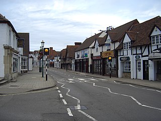
Longdon is a district of Solihull, in the West Midlands, England. Located in the east of the town, it was historically a distinct settlement that pre-dated the planted borough of Solihull, but is now mostly contiguous with Solihull town center. [1]
Longdon is a district of Solihull, in the West Midlands, England. Located in the east of the town, it was historically a distinct settlement that pre-dated the planted borough of Solihull, but is now mostly contiguous with Solihull town center. [1]
Longdon was once a clearing in the Forest of Arden with strips of land cleared and farmed in common. The first record of Longdon was as Langedone, meaning 'long hill' in 1086. The long hill is now Solihull's Marsh Lane and Yew Tree Lane, leading from the River Blythe up onto Elmdon Heath. The Manor's seat, Longdon Hall, was at its southern fringe on Copt Heath next to the settlement of Knowle. The manor bordered onto Knowle (then itself part of the Manor of Hampton in Arden), with Purnell's Brook (in Saxon times the Merebroc) acting as the boundary brook between the Knowle and Longdon manors, and later the parish boundary. [2]
Alwin of Arden, nephew of Leofric, Earl of Mercia, had held the manor before the Norman Conquest and passed it to his son Thorkell of Arden. Thorkell passed it to his own son Siward de Arden. After Siward the manor passed to Ketelbern de Langdon.
Ketelbern founded Henwood Priory and gave his name to the settlement of Catherine-de-Barnes in Longdon (Catherine being a corruption of Ketlebern). [2]

After the founding of Solihull as a planted borough between 1170 and 1180, the new settlement of Solihull began to subsume the settlement at Longdon.
At some stage the manor of Longdon came into the possession of Edward I. [3]
Another settlement known as Copt Heath, which borders Knowle, is believed to take its name from Roger de la Coppe from 1247. [4]
In the Western boundary of the manor was a farm called Malvern, belonging to Simon de Malverne, believed to be of Malvern in Worcestershire. It is recorded that Simon was assassinated in 1317. A moated site opposite the end of Marsh Lane is believed to be the de Malvern former home. [5]
In 1371 Widney Manor was considered a sub manor of Longdon. [2]
By the Elizabethan era the manor of Longdon had passed to the Greswolde family of Solihull, who had lived in Lime Tree House in Solihull (now erroneously known as the Manor House as no Lord of the Manor ever lived there). John Greswolde's daughter Alice married Thomas Dabridgecourt and the manor passed with her to him.
The Malvern area of Longdon had been the property of Parliamentarian commander Robert Greville. The Greville family remained important to the area, with Fulke Greville, 5th Baron Brooke being erroneously recorded as the Lord of the Manor of Longdon in 1682. [2]

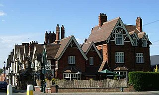
The Greswolde's remained in Longdon after the loss of the manor. In 1680 the Rev. Henry Greswolde, then rector of Solihull, bought Malvern Farm, in Longdon Manor, to establish a new family seat, which would be called Malvern Hall. [6]
Opposite Malvern Hall to the rear is another Grade II listed property called Malvern House dating from the mid 17th century. This building was once home to Solihull School until they moved to their present site in 1882, and it is today used as offices. [6]
In the 17th century the old Longdon Hall was demolished and a new Longdon Hall constructed. By this point in history the integration of the settlement of Longdon into the larger settlement of Solihull was complete. [3]
The manor of Longdon came to famous poet Lord Byron in 1815 by his marriage with Anne, daughter of Sir Ralph Milbanke Noel, and on her death in 1860 passed to her grandson the Earl of Lovelace. Two roads in Solihull are named after the family, Lady Byron Lane and Lovelace Avenue. Longdon Hall, with its remaining manorial rights, was later bought by a solicitor, Mr. J. B. Clarke of Birmingham in 1899 and soon afterwards sold to Mr. Alfred Lovekin, a silversmith. [5]
In the 1980s ownership of Longdon Hall passed to the adjacent Golf Club, known as Copt Heath Golf Club. The Hall was later sold privately in 2011. It is Grade II listed. [7]
The Longdon area covers Malvern and Brueton Parks in Solihull town center, as well as the villages of Catherine-de-Barnes and the hamlet of Copt Heath.
Longdon is split in half by the M42 motorway, and is served by junction 5. The Grand Union Canal passes through the Longdon area and is served by Copt Heath wharf. [8]
Knowle is a large village situated 3 miles (5 km) east-southeast of the town of Solihull, West Midlands, England. Knowle lies within the Arden area of the historic county boundaries of Warwickshire, and since 1974 it has been part of the Metropolitan Borough of Solihull within the West Midlands. It lies 2.5 miles from the Warwickshire border and had a recorded population of 10,678.

Hampton in Arden is a village and civil parish located in the Forest of Arden in the Metropolitan Borough of Solihull, in the West Midlands of England. Hampton in Arden was part of Warwickshire until the 1974 boundary changes. It lies within the Meriden Gap which is an area of countryside between Solihull and Coventry.

The Metropolitan Borough of Solihull is a metropolitan borough in West Midlands county, England. It is named after its largest town, Solihull, from which Solihull Metropolitan Borough Council is based. For Eurostat purposes it is a NUTS 3 region and is one of seven boroughs or unitary districts that comprise the "West Midlands" NUTS 2 region. Much of the large residential population in the north of the borough centres on the communities of Castle Bromwich, Kingshurst, Marston Green and Smith's Wood as well as the towns of Chelmsley Wood and Fordbridge. In the south are the towns of Shirley and Solihull, as well as the large villages of Knowle, Dorridge, Meriden and Balsall Common.

The Forest of Arden is a former forest and culturally defined area located in the English West Midlands, that in antiquity and into the Early Modern Period included much of Warwickshire, and parts of Shropshire, Staffordshire, the West Midlands, and Worcestershire. It is associated with William Shakespeare as a territory of his youth, and the setting of some of his drama.
Meriden is a constituency represented in the House of Commons of the UK Parliament since 2019 by Saqib Bhatti, a Conservative. It is named after the village of Meriden, halfway between Solihull and Coventry.
Dorridge is a large village in the Metropolitan Borough of Solihull in the West Midlands (county), England. Historically part of the historic county of Warwickshire, the village is encompassed within the electoral ward of Dorridge and Hockley Heath, which had a population of 11,140 in the 2011 census.

Bickenhill is a village in the civil parish of Bickenhill and Marston Green, in the Metropolitan Borough of Solihull, in the West Midlands county, England, on the eastern fringe of the West Midlands conurbation. Bickenhill is also a ward and was within the historic county of Warwickshire. Birmingham Airport is also located within the civil parish.

Hockley Heath is a large village and civil parish in the Arden area mostly within the Metropolitan Borough of Solihull, West Midlands, England. It incorporates the hamlet of Nuthurst, and has a history dating back to the year 705 AD as a wood owned by Worcester Cathedral. The parish, known as Nuthurst cum Hockley Heath, is to the south of the West Midlands conurbation, 12 miles (19 km) southeast of Birmingham 5.5 miles (8.9 km) from Solihull town centre and 13 miles (21 km) north of Stratford-upon-Avon. The village forms part of the border with Warwickshire and the District of Stratford-on-Avon to the south, with some parts of the village on either side of the border. According to the 2001 census, the parish had a population of 6,771, being measured at the 2011 Census as 2,038.
Catherine-de-Barnes is a small village within the Metropolitan Borough of Solihull in the English county of West Midlands. It is situated about 2.25 miles east of Solihull town centre, in the civil parish of Hampton in Arden, and 2 miles west of Hampton village. Population as taken in the 2011 census can be found under Bickenhill.

Dickens Heath is a large modern village and civil parish within the Metropolitan Borough of Solihull in the English county of West Midlands incorporating the much older hamlet of Whitlocks End. It was previously part of the civil parish of Hockley Heath, and borders Cheswick Green and Tidbury Green in Solihull, as well as Hollywood in Worcestershire.

Tanworth-in-Arden is a village and civil parish in the county of Warwickshire, England. It is 12.5 miles (20 km) south-southeast of Birmingham, 5.5 miles (9 km) north-east of Redditch and 8 miles south-southwest of Solihull and is administered by Stratford-on-Avon District Council. Situated in the far west of the county and close to the Worcestershire border, the civil parish is larger than the village, and includes Tanworth-in-Arden itself plus the nearby settlements of Earlswood, Wood End, Forshaw Heath, Aspley Heath and Danzey Green. The population of the parish was 3,228 at the 2021 UK census.

The Arden family is an English gentry family that can be traced back in the male line to Anglo-Saxon landholders who managed to maintain status after the 1066 invasion of England by the Normans of France.
Solihull is a market town and the administrative centre of the Metropolitan Borough of Solihull, in the West Midlands, England. Solihull is situated on the River Blythe in the Forest of Arden area. The town had a population of 126,577 at the 2021 Census, and its wider borough had a population of 216,240. The town is located 8 miles (12 km) southeast of Birmingham and 13 miles (21 km) west of Coventry.

Coughton is a small village located between Studley 2.4 miles (4 km) to the North and Alcester, 2 miles (3 km) to the South, in the county of Warwickshire, England. The village lies 19.3 miles (31 km) from Birmingham on the Birmingham–Alcester A435 road, which here follows the line of the Roman road Icknield Street. The village mainly consists of a number of houses on Sambourne Lane, Coughton Lane and farms and is primarily noted as being the location of the National Trust property, Coughton Court, which lies 400 yards to the east of the A435. The population according to the 2001 Census was 139, increasing to 157 in the 2011 Census.

Monkspath is a large residential community and light-industrial area of Solihull, West Midlands, England, southeast of the town's Shirley district. Monkspath is in the Blythe ward of the Metropolitan Borough of Solihull.

Bentley Heath is a village in the West Midlands Borough of Solihull, England, approximately 3 miles southeast of Solihull town centre. The population taken at the 2011 census can be found under the Local Authority.
Major's Green is a village in the Wythall parish of Bromsgrove district and is the northeastern-most settlement in the county of Worcestershire, England.