Longney and Epney

Last updated
Longney and Epney
St Laurence's, Longney - geograph.org.uk - 103815.jpg
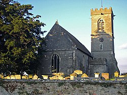
St Laurence's church, Longney
The Anchor Inn on the River Severn at Epney - geograph.org.uk - 791375.jpg
The Anchor Inn, Epney
Gloucestershire UK location map.svg
Red pog.svg
Longney and Epney
Location within Gloucestershire
Population288 (2011 census)
Civil parish
  • Longney and Epney
District
Shire county
Region
Country England
Sovereign state United Kingdom
Police Gloucestershire
Fire Gloucestershire
Ambulance South Western
List of places
UK
England
Gloucestershire
51°48′11″N2°20′38″W / 51.8030°N 2.3440°W / 51.8030; -2.3440

Longney and Epney, formerly just Longney is a civil parish in the Stroud district, in the county of Gloucestershire, England. In 2011, it's population was 288. [1] It has a parish council, the lowest tier of local government. The parish includes the village of Longney and the hamlet of Epney.

Contents

The area of the parish is 745.95 acres. [1]

History

On 24 October 2003 the parish was renamed from "Longney" to "Longney and Epney". [2]

See also

Related Research Articles

<span class="mw-page-title-main">Cotswold District</span> Non-metropolitan district in England

Cotswold is a local government district in Gloucestershire, England. It is named after the wider Cotswolds region and range of hills. The council is based in the district's largest town of Cirencester. The district also includes the towns of Chipping Campden, Fairford, Lechlade, Moreton-in-Marsh, Northleach, Stow-on-the-Wold and Tetbury, along with numerous villages and surrounding rural areas.

<span class="mw-page-title-main">Kingswood, South Gloucestershire</span> Town in Gloucestershire, England

Kingswood is a town and civil parish in the South Gloucestershire district of the ceremonial county of Gloucestershire, England. The town is situated 3 miles (4.8 km) east-northeast of Bristol.

<span class="mw-page-title-main">Stroud District</span> Non-metropolitan district in England

Stroud District is a local government district in Gloucestershire, England. The district is named after its largest town of Stroud. The council is based at Ebley Mill in Cainscross. The district also includes the towns of Berkeley, Dursley, Nailsworth, Stonehouse and Wotton-under-Edge, along with numerous villages and surrounding rural areas. Over half of the district lies within the Cotswolds Area of Outstanding Natural Beauty.

<span class="mw-page-title-main">Forest of Dean District</span> Non-metropolitan district in England

Forest of Dean is a local government district in west Gloucestershire, England, named after the Forest of Dean. Its council is based in Coleford. Other towns and villages in the district include Blakeney, Cinderford, Drybrook, English Bicknor, Huntley, Littledean, Longhope, Lydbrook, Lydney, Mitcheldean, Newnham and Newent.

<span class="mw-page-title-main">Mangotsfield</span> Human settlement in England

Mangotsfield is a village and former civil parish in the unitary authority area of South Gloucestershire, in the ceremonial county of Gloucestershire, England, to the north-east of Bristol.

<span class="mw-page-title-main">Downend, South Gloucestershire</span> Residential suburb of Greater Bristol, England

Downend is an affluent residential suburb of Greater Bristol, England, the housing stock is typically terraced Victorian, 1930s and 1950s semi-detached and detached. It is in the South Gloucestershire local district, located to the northeast of Bristol and bordered by the Bristol City suburb of Fishponds, and the South Gloucestershire suburbs of Staple Hill, Frenchay, Mangotsfield, and Emersons Green.

<span class="mw-page-title-main">Hawkesbury, Gloucestershire</span> Village and civil parish in South Gloucestershire, UK

Hawkesbury is a hamlet and civil parish in South Gloucestershire, England. The hamlet, consisting of a few cottages around a triangular green, lies west of Hawkesbury Upton, off the A46 road.

Stroud and Thornbury was a county constituency represented in the House of Commons of the Parliament of the United Kingdom. It elected one Member of Parliament (MP) by the first past the post system of election.

<span class="mw-page-title-main">Broughton Poggs</span> Human settlement in England

Broughton Poggs is a village in the civil parish of Filkins and Broughton Poggs, in the West Oxfordshire district, in the county of Oxfordshire, England. Broughton Poggs is 3 miles (5 km) southwest of Carterton.

<span class="mw-page-title-main">Filkins</span> Human settlement in England

Filkins is a village in the civil parish of Filkins and Broughton Poggs, in the West Oxfordshire district, in the county of Oxfordshire, England. It is about 2.5 miles (4 km) southwest of Carterton.

<span class="mw-page-title-main">Widford, Oxfordshire</span> Human settlement in England

Widford is a deserted medieval village in the civil parish of Swinbrook and Widford, in the West Oxfordshire district, in the county of Oxfordshire, England. It is on the River Windrush about 1.5 miles (2.4 km) east of Burford. The village was an exclave of Gloucestershire until 1844.

<span class="mw-page-title-main">Lulsley</span> Human settlement in England

Lulsley is a village and civil parish in the Malvern Hills District of the county of Worcestershire, England, UK.

Hillhampton is a hamlet and civil parish nestled between Great Witley, Little Witley and Shrawley in the Malvern Hills district of the county of Worcestershire, England.

<span class="mw-page-title-main">Fretherne with Saul</span> Civil parish in Stroud, England

Fretherne with Saul is a civil parish in the Stroud district of Gloucestershire, England. It includes the villages of Framilode, Fretherne, Saul and Upper Framilode.

<span class="mw-page-title-main">Whitstone Hundred</span>

Whitstone was an ancient hundred of Gloucestershire, England. From the 13th century it comprised two adjacent divisions, which included the ancient parishes of:

<span class="mw-page-title-main">Charlton Hayes</span> Human settlement in England

Charlton Hayes is a mixed-use development and civil parish in the South Gloucestershire district, in the ceremonial county of Gloucestershire, England. It is located on land north of the old Filton Airfield and is a new extension to Patchway. Planning permission was granted by South Gloucestershire Council in 2008 to build 2,200 homes for 6,000 residents. Charlton Hayes was named after the village of Charlton, which was demolished in the late 1940s to make way for the Filton Airfield runway extension.

<span class="mw-page-title-main">Epney</span> Human settlement in England

Epney is a small village in the civil parish of Longney and Epney, in the Stroud district, in Gloucestershire, England, on the River Severn, 8 miles (13 km) South-West of Gloucester. It is between Longney and Upper Framilode. The village has a pub called The Anchor Inn.

<span class="mw-page-title-main">Longney</span> Human settlement in England

Longney is a village in the civil parish of Longney and Epney, in the Stroud district, in Gloucestershire, England, on the River Severn 5 miles south-west of Gloucester. The parish is long and narrow and the main trades are agricultural, with several farms throughout. Longney is the Saxon name meaning a long island. The population of the Longney and Epney parish is 285 (2011).

<span class="mw-page-title-main">Borough of Tewkesbury</span> Non-metropolitan district and borough in England

The Borough of Tewkesbury is a local government district with borough status in Gloucestershire, England. The borough is named after its largest town, Tewkesbury, which is where the council is based. The district also includes the town of Winchcombe and numerous villages including Bishops Cleeve, Ashchurch, Churchdown, Innsworth and Brockworth as well as other hamlets and surrounding rural areas. Parts of the district lie within the Cotswolds Area of Outstanding Natural Beauty.

References

  1. 1 2 "Custom report - Nomis - Official Census and Labour Market Statistics". www.nomisweb.co.uk.
  2. "Gloucester Registration District". UKBMD. Retrieved 27 June 2024.