Longney

Last updated
Longney
St Laurence's, Longney - geograph.org.uk - 103815.jpg
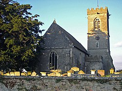
St Laurence's Church, Longney
Gloucestershire UK location map.svg
Red pog.svg
Longney
Location within Gloucestershire
Population285 (Longney and Epney parish, 2011 Census)
Civil parish
  • Longney and Epney
District
Shire county
Region
Country England
Sovereign state United Kingdom
Post town Gloucester
Postcode district GL2
Police Gloucestershire
Fire Gloucestershire
Ambulance South Western
UK Parliament
List of places
UK
England
Gloucestershire
51°48′33″N2°20′54″W / 51.8091°N 2.3484°W / 51.8091; -2.3484

Longney is a village on the River Severn 5 miles south-west of Gloucester, Gloucestershire, England, within the parish of Longney and Epney. The parish is long and narrow and the main trades are agricultural, with several farms throughout. Longney is the Saxon name meaning a long island. [1] The population of the Longney and Epney parish is 285 (2011). [2]

Two roads run through the village. The first, Longney Road, leads to Elmore and Hardwicke, the other to Epney. Many houses were built in conjunction with the Gloucester and Sharpness Canal, brick construction provided by local brick works. Thatching for houses was from the reed beds at Frampton-on-Severn. [3]

The local school is a Church Of England Primary. [4] [5] The Grade I listed village church dedicated to St Laurence dates to the 13th century, and has a 14th-century tower. [6] [7] The ecclesiastical parish is part of the benefice of Hardwicke and Elmore with Longney, which is part of the Diocese of Gloucester. [8]

Related Research Articles

<span class="mw-page-title-main">Churchdown</span> Human settlement in England

Churchdown is a large village in Gloucestershire, England, situated between Gloucester and Cheltenham in the south of the Tewkesbury Borough.

<span class="mw-page-title-main">Newnham on Severn</span> Human settlement in England

Newnham or Newnham on Severn is a village in west Gloucestershire, England. It lies in the Royal Forest of Dean, on the west bank of the River Severn, approximately 10 miles south-west of Gloucester and three miles southeast of Cinderford. It is on the A48 road between Gloucester and Chepstow, Monmouthshire, Wales. The village has a parish council.

<span class="mw-page-title-main">Minsterworth</span> Human settlement in England

Minsterworth is a village in Gloucestershire, England. It lies on the border of the City of Gloucester, on the north bank of the River Severn and on the A48 road between Gloucester and Chepstow.

<span class="mw-page-title-main">Littleton-upon-Severn</span> Human settlement in England

Littleton-upon-Severn is a village and former civil parish, now in the parish of Aust, in the South Gloucestershire district, in the ceremonial county of Gloucestershire, England, near the mouth of the River Severn and is located to the west of Thornbury. Historically it belonged to the Hundred of Langley and Swinehead. In 1931 the parish had a population of 179. On 1 April 1935 the parish was abolished and merged with Aust.

<span class="mw-page-title-main">Hardwicke, Stroud</span> Human settlement in England

Hardwicke is a large village on the A38 road 7 km south of the city of Gloucester, Gloucestershire, England. Despite its proximity to Gloucester, the village comes under Stroud Council. The population of the village taken at the United Kingdom Census 2011 was 3,901.

<span class="mw-page-title-main">Quedgeley</span> Human settlement in England

Quedgeley is a suburban town of Gloucester, located 3.5 miles (5.6 km) southwest of the city centre, in the county of Gloucestershire, England. A thin strip of land between the Severn and the Gloucester Ship Canal occupies the west, and the south-eastern part of the town is Kingsway Village, directly to the north of which is Tuffley.

<span class="mw-page-title-main">Arlingham</span> Human settlement in England

Arlingham is a village and civil parish in the Stroud District of Gloucestershire, England. The 2001 Census recorded a parish population of 410, increasing to 459 at the 2011 census. The parish contains the hamlets of Milton End, Overton and Priding. The next parish to the east is Fretherne with Saul.

<span class="mw-page-title-main">Westbury-on-Severn</span> Human settlement in England

Westbury-on-Severn is a rural village in England that is the centre of the large, rural parish, also called Westbury-on-Severn.

Stroud and Thornbury was a county constituency represented in the House of Commons of the Parliament of the United Kingdom. It elected one Member of Parliament (MP) by the first past the post system of election.

<span class="mw-page-title-main">Siddington, Gloucestershire</span> Village and parish in Gloucestershire, England

Siddington is a village and civil parish in Gloucestershire, England. It is located immediately south of Cirencester. At the 2011 United Kingdom Census, the parish had a population of 1,249.

<span class="mw-page-title-main">Maisemore</span> Human settlement in England

Maisemore is a village and civil parish in Gloucestershire, England. It lies on the A417 road 2.5 miles (4 km) northwest of Gloucester, on the west bank of the River Severn. In the 2001 census the parish had a population of 488, reducing to 458 at the 2011 census.

<span class="mw-page-title-main">Fretherne with Saul</span> Civil parish in Stroud, England

Fretherne with Saul is a civil parish in the Stroud district of Gloucestershire, England. It includes the villages of Framilode, Fretherne, Saul and Upper Framilode.

<span class="mw-page-title-main">Whitstone Hundred</span>

Whitstone was an ancient hundred of Gloucestershire, England. From the 13th century it comprised two adjacent divisions, which included the ancient parishes of:

<span class="mw-page-title-main">Westgate, Gloucester</span>

The Westgate area of Gloucester is centred on Westgate Street, one of the four main streets of Gloucester and one of the oldest parts of the city. The population of the Westgate ward in Gloucester was 6,687 at the time of the 2011 Census.

Severn FM is an internet radio station in the United Kingdom, which started broadcasting online in June 2011, and officially launched from its studio in Hardwicke on 3 December 2011 with the Severn Bore Breakfast Show, the launch coincided with its first 28-day RSL broadcast on 87.9 FM. The brainchild of Andy Clarke who used his skills gained as a mobile network consultant, it initially followed the standard community radio model but has evolved along the way under the leadership of Andy and his Board of Directors along with the presenters and other volunteers who form part of this growing and evolving South Gloucester "Community Project".

Hunts Grove is a new build suburb, situated near the villages of Hardwicke and Haresfield, on the southern edge of the city of Gloucester. Building began in 2010 and the estate is as yet unfinished. The development was named Hunts Grove after the small woodland, Hunts Grove, on the site.

<span class="mw-page-title-main">Haresfield</span> Human settlement in England

Haresfield is a village near Gloucester, Gloucestershire, England around one mile from Junction 12 of the M5 motorway and between the villages of Brookthorpe, Harescombe and Hardwicke. The population of the village taken at the 2011 census was 378.

<span class="mw-page-title-main">Epney</span> Human settlement in England

Epney is a small village on the River Severn. It is 8 miles (13 km) South-West of Gloucester, Gloucestershire, England within the parish of Longney and Epney. It is between Longney and Upper Framilode. The village has a pub called The Anchor Inn. The population of the Longney and Epney parish is 285 (2011).

References

  1. "Longney: Introduction". British History Online. Retrieved 7 August 2016.
  2. "Population of Longney and Epney". Neighbourhood Statistics. Retrieved 7 August 2016.
  3. "Longney and Epney Parish Design Statement" (PDF). Longney and Epney Parish. Retrieved 16 August 2016.
  4. "Longney School". Longney and Epney. Retrieved 7 August 2016.
  5. "Longney C of E Primary Academy". Longney C of E Primary Academy. Retrieved 16 August 2016.
  6. "Church - St Laurence, Longney". LongneyandEpney - Its a Tale of Two Islands. Retrieved 7 August 2016.
  7. "Church of St. Lawrence". National Heritage List for England. Historic England. Retrieved 7 August 2016.
  8. "Longney: St Lawrence, Longney". A Church Near You. Church of England. Retrieved 16 August 2016.

Coordinates: 51°48′33″N2°20′54″W / 51.8091°N 2.3484°W / 51.8091; -2.3484