
Lacey Township is a township in Ocean County, New Jersey and is considered part of the Jersey Shore and South Jersey regions. As of the 2010 United States Census, the township's population was 27,644, reflecting an increase of 2,298 (+9.1%) from the 25,346 counted in the 2000 Census, which had in turn increased by 3,205 (+14.5%) from the 22,141 counted in the 1990 Census. The 2010 population was the highest recorded in any decennial census. It was named for Continental Army General John Lacey.

Lacey is a city in Thurston County, Washington, United States. It is a suburb of Olympia with a population of 42,393 at the 2010 census. Lacey is located along Interstate 5 between Olympia and the Nisqually River, which marks the border with Pierce County and Joint Base Lewis–McChord.

Great Bookham is a village in Surrey, England, one of six semi-rural spring line settlements between the towns of Leatherhead and Guildford. With the narrow strip parish of Little Bookham, it forms part of the Saxon settlement of Bocham. The Bookhams are surrounded by common land, and Bookham railway station in Church Road, Great Bookham, serves both settlements.

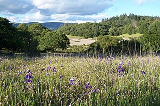
Austin Creek State Recreation Area is a state park unit of California, United States, encompassing an isolated wilderness area. It is located in Sonoma County, California, adjacent to Armstrong Redwoods State Natural Reserve, with which it shares a common entrance. Its rugged topography includes ravines, grassy hillsides, oak-capped knolls, and rocky summits offering glimpses of the Pacific Ocean. There are 20 miles (30 km) of trails, panoramic wilderness views, and camping. The remains of Pond Farm artists' colony are also included in the Austin Creek SRA.

The Rouge River is a river in Markham, Pickering, Richmond Hill and Toronto in the Greater Toronto Area of Ontario, Canada. The river flows from the Oak Ridges Moraine to Lake Ontario at the eastern border of Toronto, and is the location of Rouge Park, the only national park in Canada within a municipality. At its southern end, the Rouge River is the boundary between Toronto and southwestern Pickering in the Regional Municipality of Durham.

Strathmore is a suburb of Melbourne, Victoria, Australia and is situated approximately 10 km north-west of Melbourne's central business district. Strathmore is part of the City of Moonee Valley local government area. At the 2016 Census, Strathmore had a population of 8,419.

The Moonee Ponds Creek is a creek and major tributary of the Yarra River running through urban Melbourne, Victoria, Australia from northern to inner suburbs. In 2004 a reporter for the Age newspaper described it as "arguably the most abused tributary of the Yarra River, and part of the true underside of Melbourne".
The Moonee Ponds Creek Trail is a shared use path for cyclists and pedestrians, which follows the Moonee Ponds Creek through the northern suburbs of Melbourne, Victoria, Australia.

Topanga State Park is a California state park located in the Santa Monica Mountains, within Los Angeles County, California. It is part of the Santa Monica Mountains National Recreation Area. The park has been closed since April 7, 2020 due to the Coronavirus pandemic.
Trione-Annadel State Park is a state park of California in the United States. It is situated at the northern edge of Sonoma Valley and is adjacent to Spring Lake Regional Park in Santa Rosa. It offers many recreational activities within its 5,092-acre (2,061 ha) property.
The Magothy River runs 12.1 miles (19.5 km) through Anne Arundel County in the U.S. state of Maryland. It is located south of the Patapsco River and north of the Severn River. There are two public park paddling access points, Beachwood Park on the north shore a half mile east of the Magothy Bridge Road bridge, and Spriggs Farm Park off Bayberry Drive, on the south shore two miles west of the Magothy's mouth. Both are Anne Arundel County parks.
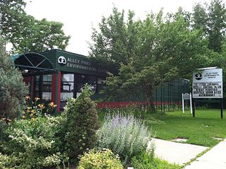
Alley Pond Park is the second-largest public park in Queens, New York City, occupying 655.3 acres (265.2 ha). The park is bordered to the east by Douglaston, to the west by Bayside, to the north by Little Neck Bay, and to the south by Union Turnpike. Cross Island Parkway travels north-south through the park, while the Long Island Expressway and Grand Central Parkway travel east-west through the park. The park primarily consists of woodlands south of the Long Island Expressway and meadowlands north of the expressway. It is run and operated by the New York City Department of Parks and Recreation.

Muddy Kill is a 4.2-mile-long (6.8 km) tributary of the Wallkill River that runs entirely through the town of Montgomery in Orange County, New York, United States. It rises from a small pond just over a mile (1.7 km) west of the village of Walden, flowing first southwesterly then roughly due south to empty into the Wallkill just upstream from the village of Montgomery.
Long Pond Park is a park preserve on the South Shore of Staten Island, New York City. It is approximately 115 acres (0.47 km2) in size and consists mainly of woodlands and wetlands that surround Long Pond, for which the park is named. Long Pond Park is roughly bounded by Hylan Boulevard on the south, Page Avenue on the west, Amboy Road on the north, and Richard Avenue on the east. It is an important stopping point for migrating birds in the Atlantic Flyway.

Alhambra Creek is a stream in Contra Costa County, in the East Bay region of the San Francisco Bay Area in northern California.

Rood Bridge Park is a municipal park in southeast Hillsboro, Oregon, United States. Opened in 1999, the park encompasses 60 acres (24 ha) on the north bank of the Tualatin River at its confluence with Rock Creek. Rood Bridge is near Hillsboro High School and sits across the river from Meriwether National Golf Course. The park is the city’s largest, and contains tennis courts, a meeting facility, trails, a canoe launch, and a rhododendron garden among other features.

The Dunns Pond Mound is a historic Native American mound in northeastern Logan County, Ohio, United States. Located near Huntsville, it lies along the southeastern corner of Indian Lake in Washington Township. In 1974, the mound was listed on the National Register of Historic Places as a potential archeological site, with much of its significance deriving from its use as a burial site for as much as nine centuries.

The Nurragingy Nature Reserve is an Australian open urban park and forest, nature reserve and garden, it is a protected area owned by Western Sydney Parklands Trust and operated by Blacktown City Council that opened in 1981. The Nature Reserve is a site of state heritage significance because of its combination of historical, social and cultural values. The site was the first land grant ever given to Aboriginal people in Australia. The land grant is associated with two significant Aboriginal figures from the early colonial period-Nurragingy and Colebee-to whom the land was jointly granted in 1816. The location of the land grant is significant because it was an Aboriginal choice, being on land belonging to Nurragingy's clan. The land grant is valued by the contemporary Aboriginal community and the wider Australian community as a landmark in the history of cross-cultural engagement in Australia. For Aboriginal people, in particular, it represents a key historical site symbolising Aboriginal resilience and enduring links to the land. The landscaped park is complete with unique features including bridges, pavilions and waterfalls, a native wildlife park, Chinese garden, New Zealand Garden, BBQ and picnic area and large conference centre for business meetings, weddings and other varying functions, it is a popular tourist attraction located in Knox Rd, Doonside and Rooty Hill, New South Wales
Baisley Pond Park is a public park located in the southeastern part of Queens, New York City, bordering the neighborhoods of South Jamaica, Rochdale, and St. Albans. It covers 109.61 acres (44.36 ha), including the 30-acre (12 ha) Baisley Pond in the center of the park. It is maintained by the New York City Department of Parks and Recreation.
The Karen Fraser Woodland Trail is a 4.7-mile (7.6 km) paved rail trail in Thurston County, Washington that connects the cities of Olympia and Lacey along the abandoned Burlington Northern corridor. The trail opened in 2007 and connects with the Chehalis Western Trail at the border between the two cities. The Olympia trailhead features a sustainably designed shelter and restroom with a living roof and a rain garden and parts of the trail run alongside Indian Creek.
