Lookout Place

Last updated

Lookout Place or Fort Hill atop LaTourette Hill in late nineteenth century Lookoutfort.jpg
Lookout Place or Fort Hill atop LaTourette Hill in late nineteenth century
Map dated 1874 showing Lookout Place above Fresh Kills Creek Forthillmap.jpg
Map dated 1874 showing Lookout Place above Fresh Kills Creek

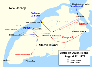
Lookout Place or Fort Hill (also known as Fort Izard) was an American Revolutionary War British garrison, or earthen mound-fortress roughly 44 feet square at the top of La Tourette Hill in Historic Richmondtown, Staten Island, New York. The redoubt was constructed in 1776 by British Regulars during the occupation of Richmond County. General William Howe planned his successful capture of New York City while encamped on the Island, along with 30,000 British and Hessian soldiers joining to suppress the rebellion after the arrival of his brother Admiral Richard Howe. The fort overlooked a fresh water spring about 200 feet directly below (known as the Lord Howe Spring), the Old Mill Road, Fresh Kills which is a tributary of Richmond Creek, St. Andrews Church and the town of Richmond, then referred to as Cuckoldstown, in the valley just below La Tourette Hill.

American Revolutionary War War between Great Britain and the Thirteen Colonies, which won independence as the United States of America

The American Revolutionary War (1775–1783), also known as the American War of Independence, was an 18th-century war between Great Britain and its Thirteen Colonies which declared independence as the United States of America.

Commonly used to describe the Napoleonic era British foot soldiers, the British Regulars were known for their distinct red uniform and well-disciplined combat performance. Known famously in British folklore as the Red Coats, these hardened soldiers were the backbone of the British Army in the eighteenth and nineteenth centuries.

William Howe, 5th Viscount Howe British General in the American War of Independence

General William Howe, 5th Viscount Howe, KB, PC was a British Army officer who rose to become Commander-in-Chief of British forces during the American War of Independence. Howe was one of three brothers who had distinguished military careers. In historiography of the American war he is usually referred to as Sir William Howe in distinction to his brother Richard, who held the title of Lord Howe at that time.

The hilltop was widely denuded of trees by the British during the war, allowing the soldiers to have unobstructed views of Lower New York Bay and the Arthur Kill. It is now the La Tourette Golf Course.

Lower New York Bay bay in New York, USA

Lower New York Bay is a section of New York Bay south of the Narrows, the relatively narrow strait between the shores of Staten Island and Brooklyn. The southern end of the bay opens directly to the Atlantic Ocean between two spits of land, Sandy Hook, New Jersey, and Rockaway, Queens, on Long Island. The southern portion between Staten Island and New Jersey, at the mouth of the Raritan River, is named Raritan Bay. The Hudson Canyon, the ancient riverbed of the Hudson River which existed during the last ice age when the ocean levels were lower, extends southeast from Lower New York Bay for hundreds of miles into the Atlantic Ocean. The nearby part of the Atlantic Ocean between New Jersey and Long Island is the New York Bight.

Arthur Kill Navigational channel of the Port of New York and New Jersey

Arthur Kill, also known as the Staten Island Sound, is a tidal strait and a kill between Staten Island, a borough of New York City, and Union and Middlesex counties in northern New Jersey. It is a major navigational channel of the Port of New York and New Jersey in the United States.

Extensive archeological digs have taken place at the beginning of the 20th century, [1] revealing all manner of British accuetrament, from remnants of weaponry to soldier coat buttons, shoe buckles and pottery fragments. [2]

Robert Rogers created a new unit while encamped at Richmondtown called The Queen's Rangers named after Charlotte, wife of King George III.

Queens Rangers

The Queen's Rangers, also known as the Queen's American Rangers, and later Simcoe's Rangers, were a Loyalist military unit of the American Revolutionary War. They were named for Queen Charlotte, consort of George III. Formed as a light corps in the tradition of the ranging companies in British service during the Seven Years' War, the Queen's Rangers operated on the flanks and in advance of Crown forces, manning outposts and patrolling, as well as carrying out reconnaissance and raiding operations.

Related Research Articles

Richmondtown, Staten Island human settlement in New York, United States of America

Richmondtown is a neighborhood in the Mid-Island section of Staten Island, New York City. It is bounded by Arthur Kill Road on the northwest, Richmond Road on the north, Amboy Road on the east and southeast, and the United Hebrew and Ocean View cemeteries on the southwest.

Fresh Kills Landfill Landfill site

The Fresh Kills Landfill was a landfill covering 2,200 acres (890 ha) in the New York City borough of Staten Island in the United States. The name comes from the landfill's location along the banks of the Fresh Kills estuary in western Staten Island.

South Shore, Staten Island

The South Shore is a geographical term applied to the area in the New York City borough of Staten Island, south and east of the island's ridge of hills along the waterfront and adjacent areas from the Narrows to the mouth of the Arthur Kill. Many observers prefer to restrict its scope to the neighborhoods located between the shoreline of Raritan Bay on one side and Richmond Creek and Fresh Kills on the other, thus encompassing the neighborhoods of Great Kills to Tottenville only. Those who use this narrower definition of the "South Shore" prefer the term "East Shore" for the communities that lie along Lower New York Bay, and inland for approximately 2 to 2½ miles, from Bay Terrace and Richmondtown to as far north as Grasmere and Concord. The South Shore is represented in the New York City Council by Joe Borelli.

Richmond Creek (Fresh Kills) stream in Staten Island, New York, United States of America

Richmond Creek is a major stream in Staten Island, a borough of New York City in the United States. Its upper drainage basin includes the remote forested hills in the center of the island. It empties into the Fresh Kills.

Moravian Cemetery cemetery on Staten Island, New York

The Moravian Cemetery is a cemetery in the New Dorp neighborhood of Staten Island, New York City. Located at 2205 Richmond Road, the Moravian is the largest and oldest active cemetery on Staten Island, having opened in 1740. The cemetery encompasses 113 acres and is the property of the local Moravian Church congregation of Staten Island. To the cemetery's southwest is High Rock Park, one of the constituent parks of the Staten Island Greenbelt.


The term East Shore is frequently applied to a series of neighborhoods along the Lower New York Bay and the Raritan Bay and within New York City's borough of Staten Island.

North Shore, Staten Island

The term North Shore is frequently applied to a series of neighborhoods within the New York City borough of Staten Island.

Lighthouse Hill is the name of a hill, and the neighborhood situated thereon, in the New York City borough of Staten Island. Lighthouse Hill is situated to the north of Richmondtown, south of Todt Hill, and west of Grant City.

Battle of Staten Island

The Battle of Staten Island was a raid by Continental Army troops under Major General John Sullivan against British forces on Staten Island on August 22, 1777, during the American Revolutionary War. After British Lieutenant General William Howe sailed with most of his army from New York in July, the Americans recognized that the British position on Staten Island was vulnerable, and planned an attack.

Rose and Crown Tavern

The Rose and Crown Tavern was a farmhouse and tavern located in New Dorp, Staten Island.

The Britton Cottage

The Britton Cottage, formerly known as the Cubberly House, is a house in the Historic Richmond Town museum complex in the neighborhood of Richmondtown, Staten Island, in New York City. The oldest section of the cottage dates to 1671, with additions in the mid-18th century. It is constructed of stone and timberframe components. The house was originally located at the intersection of New Dorp Lane and Cedar Grove Avenue in the New Dorp Beach section of Staten Island, but was moved to its current location in 1967 when it was threatened with demolition.

Boehm House building in New York, United States

The Boehm House is an historic house at 75 Arthur Kill Road in the Richmondtown section of the borough of Staten Island in New York City. This 1750 house, relocated from Greenridge as a part of Historic Richmondtown, was typical of rural New York during the American Revolution. Also on view in the house: an exhibit of early building techniques and restorations. It was designated a New York City landmark in 1969 as the "Boehm-Frost House".

The John Bennett House was built in 1839 with an addition built in 1854, was built as part of a real estate development near the Third County Courthouse in Historic Richmondtown, Staten Island, New York. This Greek Revival style residence was home to shipping merchant John Bennett and his family from c.1848-1917. The building later served as a restaurant. A seasonal cafe and restaurant is located in the cellar bakery and is accessible from Richmond Road.

Richmond Road (Staten Island)

Richmond Road is a major north-south artery along the East Shore of the New York City borough of Staten Island. It is approximately 4.93 miles (7.93 km) long, and runs through the neighborhoods of Concord, Grymes Hill, Emerson Hill, Grasmere, Old Town, Dongan Hills, Grant City, Todt Hill, New Dorp, Egbertville, Lighthouse Hill, and Richmondtown.

Arthur Kill Road

Arthur Kill Road is a major northeast-southwest artery along the South-West Shore of the New York City borough of Staten Island. It is approximately 8.70 miles (14.00 km) long, and runs through the neighborhoods of Richmondtown, Great Kills, Greenridge, Eltingville, Annadale, Arden Heights, Huguenot, Woodrow, Rossville, Charleston, Richmond Valley, and Tottenville.

St. Patricks Church (Staten Island, New York) church building in New York, United States of America

The Church of St. Patrick is a parish church under the authority of the Roman Catholic Archdiocese of New York, located in the Richmondtown area of Staten Island, New York City.

Richmond Engine Co. 1 is volunteer fire department located in the Richmondtown neighborhood of Staten Island, New York City, New York that works in cooperation with the New York City Fire Department.

Fort Hill Park is a .845-acre public green space located in the St. George neighborhood of Staten Island, New York. It is located on the slope of the northernmost hilltop on the Dongan Hills ridge.

La Tourette Golf Course

La Tourette Golf Course is a public course on Staten Island in New York City. The land is part of Staten Island's Greenbelt and has views of historic Richmond Town. The La Tourette House, which dates to 1836 and is on the National Register of Historic Places, serves as the clubhouse. Considered by some to be the crown jewel of New York City's public golf course network, it is home to the annual New York City Amateur Championship.

References

  1. New York Times|December 28, 1919
  2. New York Times|November 2, 1919

Coordinates: 40°34′50″N74°08′46″W / 40.58061°N 74.14599°W / 40.58061; -74.14599

Geographic coordinate system Coordinate system

A geographic coordinate system is a coordinate system that enables every location on Earth to be specified by a set of numbers, letters or symbols. The coordinates are often chosen such that one of the numbers represents a vertical position and two or three of the numbers represent a horizontal position; alternatively, a geographic position may be expressed in a combined three-dimensional Cartesian vector. A common choice of coordinates is latitude, longitude and elevation. To specify a location on a plane requires a map projection.