
Detroit Lake is a reservoir impounded by the Detroit Dam on the North Santiam River 46 miles (74 km) southeast of Salem, Oregon, United States. The lake is adjacent to Oregon Route 22 near the city of Detroit. This mesotrophic lake stores water for use by the city of Salem and other nearby communities.

The McKenzie River is a 90-mile (145 km) tributary of the Willamette River in western Oregon in the United States. It drains part of the Cascade Range east of Eugene and flows westward into the southernmost end of the Willamette Valley. It is named for Donald McKenzie, a Scottish Canadian fur trader who explored parts of the Pacific Northwest for the Pacific Fur Company in the early 19th century. As of the 21st century, six large dams have been built on the McKenzie and its tributaries.

Curecanti National Recreation Area is a National Park Service unit located on the Gunnison River in western Colorado. Established in 1965, Curecanti National Recreation Area is responsible for developing and managing recreational facilities on three reservoirs, Blue Mesa Reservoir, Morrow Point Reservoir and Crystal Reservoir, constructed on the upper Gunnison River in the 1960s by the U.S. Bureau of Reclamation to better utilize the vital waters of the Colorado River and its major tributaries. A popular destination for boating and fishing, Curecanti offers visitors two marinas, traditional and group campgrounds, hiking trails, boat launches, and boat-in campsites. The state's premiere lake trout and Kokanee salmon fisheries, Curecanti is a popular destination for boating and fishing, and is also a popular area for ice-fishing in the winter months.

Foster Reservoir is a reservoir created by Foster Dam on the South Santiam River in the city of Foster, Oregon, United States. The reservoir is approximately 5.6 km (3.5 mi) long and covers approximately 494 ha when full. Primary use of the reservoir is recreation in the summer and flood control in the winter and spring.

Canyon Lake is a reservoir on the Guadalupe River in the Texas Hill Country in the United States. Canyon Lake is a U.S. Army Corps of Engineers reservoir formed on the Guadalupe River in Comal County by Canyon Dam, which is located about sixteen miles northwest of New Braunfels. The dam, lake, and all adjacent property are managed by the U.S. Army Corps Of Engineers. Water rights, waste water treatment, and hydroelectric generating facilities are managed by the Guadalupe-Blanco River Authority. Construction of the dam began in 1958 and was completed in 1964. The reservoir serves to provide flood control and water supply for the communities downstream from the dam. The lake is also a popular recreational destination.

The Crooked River is a tributary, 125 miles (201 km) long, of the Deschutes River in the U.S. state of Oregon. The river begins at the confluence of the South Fork Crooked River and Beaver Creek. Of the two tributaries, the South Fork Crooked River is the larger and is sometimes considered part of the Crooked River proper. A variant name of the South Fork Crooked River is simply "Crooked River". The Deschutes River flows north into the Columbia River.

Applegate Lake is a 988-acre (400 ha) reservoir located in the Rogue River–Siskiyou National Forest about 27 miles (43 km) southwest of Medford in the U.S. state of Oregon. It is 16 miles (26 km) south of Oregon Route 238 along Applegate River Road and slightly north of the Oregon–California border. The lake is an impoundment of the Applegate River about 46 miles (74 km) from its confluence with the Rogue River.

The Middle Fork Willamette River is one of several forks that unite to form the Willamette River in the western part of the U.S. state of Oregon. It is approximately 115 miles (185 km) long, draining an area of the Cascade Range southeast of Eugene, which is at the southern end of the Willamette Valley.

Hyatt Reservoir is a reservoir in Jackson County, Oregon, United States, 14 miles (23 km) east of Ashland. Impounded by Hyatt Dam, the water is used for irrigation and recreation. A local irrigation district built the dam in 1923.
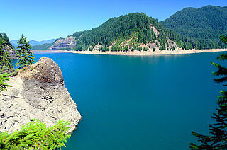
Cougar Reservoir is a reservoir on the South Fork McKenzie River in the U.S. state of Oregon. It is in Lane County, 46 miles (74 km) east of Eugene and about 3 miles (5 km) south of the community of Rainbow in the Willamette National Forest. In 1963 the United States Army Corps of Engineers built Cougar Dam on the river primarily to generate hydroelectricity and control flooding, and the reservoir formed behind the dam.

Dexter Reservoir is a reservoir in Lane County, in the U.S. state of Oregon. It is about 16 miles (26 km) southeast of Eugene on the Middle Fork Willamette River, immediately downriver from Lookout Point Lake, another reservoir. The communities of Dexter and Lowell are near the lake. Oregon Route 58 follows the lake's southern shore, while Pengra Road parallels the lake's northern shore as far east as Lowell.

Blue River Reservoir is an artificial impoundment, about 6 miles (10 km) long, of the Blue River in Lane County in the U.S. state of Oregon. The reservoir is about 1 mile (1.6 km) north of Oregon Route 126 in the Willamette National Forest about 45 miles (72 km) east of Eugene.

Hills Creek Dam is a dam about 4 miles (6.4 km) southeast of Oakridge in Lane County, Oregon, United States. It impounds Hills Creek Reservoir, which has a surface area of 2,735 acres (1,107 ha) and a shoreline of roughly 44 miles (71 km), on the Middle Fork Willamette River.
Antelope Reservoir is a large body of water impounded for irrigation in a semi-arid region of southeastern Oregon in the United States. Located near the small city of Jordan Valley in Malheur County, it is about 10 miles (16 km) west of Oregon's border with Idaho. Although the lake is formed by a dam across Jack Creek, most of the water enters the reservoir via the Antelope Feeder Canal. It diverts water to the reservoir from nearby Jordan Creek at a point near the Idaho border. Jack Creek, which carries minor outflows from the reservoir, empties into Jordan Creek further downstream.

The South Fork McKenzie River is a tributary, about 31 miles (50 km) long, of the McKenzie River in the U.S. state of Oregon. It begins at about 4,500 feet (1,400 m) above sea level near Mink Lake in the Three Sisters Wilderness of the Cascade Range. Flowing northwest within Lane County, it meets the McKenzie River about 60 miles (97 km) from the larger river's confluence with the Willamette River.
Hills Creek Reservoir, also known as Hills Creek Lake, is an artificial impoundment behind Hills Creek Dam on the Middle Fork Willamette River in the U.S. state of Oregon. The lake is near Oakridge in Lane County about 40 miles (64 km) southeast of Eugene, at the confluence of Hills Creek with the Middle Fork. The reservoir and its watershed lie within the Willamette National Forest.

John C. Boyle Reservoir is an artificial impoundment behind John C. Boyle Dam on the Klamath River in the U.S. state of Oregon. The lake is 16 miles (26 km) west-southwest of Klamath Falls along Oregon Route 66.

Fall Creek is a 34-mile (55 km) tributary of the Middle Fork Willamette River in Lane County in the U.S. state of Oregon. Beginning in the Cascade Range, the creek flows generally west through the Willamette National Forest to enter the Middle Fork upstream of Jasper, southeast of Springfield and Eugene.

Fall Creek Lake is a reservoir in Lane County, in the U.S. state of Oregon. It is about 22 miles (35 km) southeast of Eugene on Fall Creek, immediately upstream from Unity Bridge, a covered bridge. The communities of Unity, at the bridge site, and Lowell, south of Unity, are near the lake. The unincorporated community of Jasper is further downstream, below the confluence of Fall Creek with the Middle Fork Willamette River.
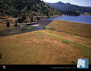
Cottage Grove Lake is a reservoir on the Coast Fork Willamette River in Lane County, Oregon, United States. The lake is about 3 miles (4.8 km) long.


