Related Research Articles

Schuylkill County is a county in the Commonwealth of Pennsylvania. It is located in the heart of Pennsylvania's Coal Region and is part of Northeastern Pennsylvania. As of the 2020 census, the population was 143,049. The county seat is Pottsville.

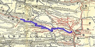
The Schuylkill River is a river running northwest to southeast in eastern Pennsylvania. The river was improved by navigations into the Schuylkill Canal, and several of its tributaries drain major parts of Pennsylvania's Coal Region. It flows for 135 miles (217 km) from Pottsville to Philadelphia, where it joins the Delaware River as one of its largest tributaries.

The Union Canal was a towpath canal that existed in southeastern Pennsylvania in the United States during the 19th century. First proposed in 1690 to connect Philadelphia with the Susquehanna River, it ran approximately 82 mi from Middletown on the Susquehanna below Harrisburg to Reading on the Schuylkill River.

This is a list of the earliest railroads in North America, including various railroad-like precursors to the general modern form of a company or government agency operating locomotive-drawn trains on metal tracks.
The Lehigh and Mahanoy Railroad, originally the Quakake Railroad, was a rail line connecting Black Creek Junction, in the Lehigh Valley, with Quakake, Delano, and Mount Carmel. Opened from Black Creek Junction to Quakake in 1858 and to Mount Carmel in 1860, it allowed anthracite coal mined along the line and bridge traffic to move east towards New York City. After 1866, it was merged into the Lehigh Valley Railroad to become its Mahanoy Branch.
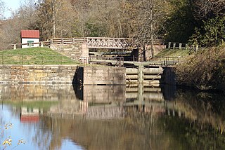
The Schuylkill Canal, or Schuylkill Navigation, was a system of interconnected canals and slack-water pools along the Schuylkill River in the U.S. state of Pennsylvania, built as a commercial waterway in the early 19th-century. Chartered in 1815, the navigation opened in 1825, to provide transportation and water power.
Oaks is an unincorporated community located in Upper Providence Township, Montgomery County, Pennsylvania, United States. The community is 18 miles (30 km) northwest of Philadelphia and its boundaries are defined in large part by the village's position at the junction of Perkiomen Creek and the Schuylkill River.
The Allentown Railroad was a railway company in the United States. It was incorporated in 1853 with the original intention to connect the Central Railroad of New Jersey at Allentown with the Pennsylvania Railroad's main line across the Allegheny Mountains. Though grading was almost entirely finished, the project was halted by the Panic of 1857, and the completion of the East Pennsylvania Railroad in 1859 made the Allentown Railroad's proposed line largely redundant. As a result, track was never laid on most of the line. The small portion that did became the Allentown branch of the Reading Company from Topton to Kutztown, and was nominally owned by the Allentown Railroad until the Reading dissolved it in 1945 to simplify corporate bookkeeping. Other Reading subsidiaries also laid track on parts of the right-of-way elsewhere along the route. The short line Allentown & Auburn Railroad continues to operate freight service on the Topton to Kutztown route.
Rausch Gap is a ghost town that is located in Cold Spring Township, Lebanon County, Pennsylvania in the United States.
The Lebanon and Tremont Branch of the Philadelphia & Reading Railroad was a railroad line in Lebanon and Schuylkill County, Pennsylvania, built to tap the coal fields in the West End of Schuylkill County and send coal southward to Lebanon.

The Lehigh Canal is a navigable canal that begins at the mouth of Nesquehoning Creek on the Lehigh River in the Lehigh Valley and Northeastern regions of Pennsylvania. It was built in two sections over a span of 20 years beginning in 1818. The lower section spanned the distance between Easton and present-day Jim Thorpe. In Easton, the canal met the Delaware and Morris Canals, which allowed anthracite coal and other goods to be transported further up the U.S. East Coast. At its height, the Lehigh Canal was 72 miles (116 km) long.
The Bellefonte and Snow Shoe Railroad was a coal-hauling railroad in Centre County, Pennsylvania. Begun in 1859, it came under the control of the Pennsylvania Railroad in 1881. Closing of mines in the 1930s resulted in the decline of traffic on the railroad, which was abandoned in 1959.
The Pennsylvania Canal, sometimes known as the Pennsylvania Canal system, was a complex system of transportation infrastructure improvements, including canals, dams, locks, tow paths, aqueducts, and viaducts. The canal was constructed and assembled over several decades beginning in 1824, the year of the first enabling act and budget items.

The Lehigh Coal & Navigation Company was a mining and transportation company headquartered in Mauch Chunk, Pennsylvania, now known as Jim Thorpe in Northeastern Pennsylvania. The company operated from 1818 until its dissolution in 1964 and played an early and influential role in the rise of the American Industrial Revolution and early U.S. industrialization. The company ultimately encompassed source industries, transport, and manufacturing, making it the first vertically integrated U.S. company.
The Williams Valley Railroad was an anthracite-hauling railroad that operated in Schuylkill and Dauphin Counties, Pennsylvania from 1892 to 1971. For most of that time, it was a subsidiary of the Reading Railroad. It extended the Reading's Brookside Branch at Brookside 11 miles (18 km) down the Williams Valley to Lykens.

The Nesquehoning Valley Railroad Company, herein called the Nesquehoning Valley Railroad (NVRR), is now a fallen flag standard-gauge, steam era shortline railroad built as a coal road to ship the Anthracite mined in the Southeastern Coal Region on either side of the Little Schuylkill River tributary Panther Creek and the history making coal towns of the Panther Creek Valley down the Lehigh River transportation corridor to the Eastern seaboard.
The Wilmington and Northern Railroad is a railway company that once owned a line from Reading, Pennsylvania to Wilmington, Delaware. The original main line from Wilmington to Birdsboro, Pennsylvania was built between 1869 and 1871 by its predecessor, the Wilmington and Reading Railroad. An extension from Birdsboro to High's Junction was completed in 1874. There the Wilmington and Reading connected with the Berks County Railroad and ran over its tracks to Reading. The Berks County Railroad was foreclosed on at the end of 1874 and reorganized as the Reading and Lehigh Railroad, under the control of the Philadelphia and Reading Rail Road. The Wilmington and Reading also experienced financial difficulties and was itself foreclosed on in 1876. It was reorganized in 1877 as the Wilmington and Northern. After the reorganization, the railroad was closely affiliated with the Reading, but retained its own organization and officers until 1898. In that year, the Reading bought a majority of the company's stock and incorporated it into its own system. The main line from Birdsboro to Wilmington became the Wilmington and Northern Branch, while the extension above Birdsboro was incorporated into the Reading Belt Line. The Wilmington and Northern continued to exist as a paper railroad within the Reading system. The portion of the Wilmington and Northern north of Modena, Pennsylvania was sold to Conrail at its formation in 1976. The line south of Modena was retained by the Wilmington and Northern, which leased and then sold it piecemeal to other railroads between 1981 and 2005. As of 2021, the Wilmington and Northern still survived as a subsidiary of Reading International, Inc.
The Mill Creek & Mine Hill Navigation and Railroad Co. was the second railroad built in Pennsylvania and the third in the United States, beginning operations in mid–1829. It was a short four mile line extending from Port Carbon, Pennsylvania along the Mill Creek towards active anthracite coal mines. Its purpose was to transport mined coal to Port Carbon which was the terminus for the Schuylkill Canal, the conduit to markets in Philadelphia.
The Mine Hill & Schuylkill Haven Railroad (MH&SH) was operating by April 1831 in Schuylkill County, Pennsylvania, from above Mine Hill Gap to Schuylkill Haven on the Schuylkill Canal. This railroad was developed by the New York and Schuylkill Coal Co., and was one of the important early "lateral" railroads of Schuylkill County which were constructed to accommodate the Schuylkill canal with coal tonnage from the more remote areas where mines were operating. In 1862 the MH&SH was leased by the Philadelphia and Reading Railroad Company (P&RR) and became part of its operation system.
The Mt. Carbon Railroad (MC) was one of what was known as lateral railroads built in Schuylkill County, Pennsylvania in the 1820s and 1830s, and which were first constructed to accommodate the Schuylkill Canal with coal produced from the coal district south of the Mine Hill and east of the West Branch Schuylkill River, covering an area of between sixty and seventy square miles. The MC opened on April 19, 1831, between the settlement of Mount Carbon, Pennsylvania, on the Schuylkill Canal, north to the Norwegian Creek confluence, and following that tributary to beyond both the East and West Norwegian Creeks. In 1842, the Philadelphia and Reading Railway Company (P&RR) made Mt. Carbon a termination point for its railroad line from Philadelphia in direct competition with the Schuylkill Canal. The P&RR leased the MC on May 16, 1862, and merged it into the parent organization on June 13, 1872.
References
- ↑ "The Statues at Large of Pennsylvania: Laws Passed 1831" . Retrieved 2010-10-28.
- ↑ "The Lincoln Colliery" . Retrieved 2006-10-26.
- Taber, Thomas T. III (1987). Railroads of Pennsylvania Encyclopedia and Atlas. Thomas T. Taber III. p. 462. ISBN 0-9603398-5-X.
| International | |
|---|---|
| National | |