
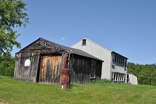
Chesham is an unincorporated community within the town of Harrisville in Cheshire County, New Hampshire, United States. Part of the village is listed on the National Register of Historic Places as the Chesham Village District, while the southernmost portions are included in the Pottersville District, also listed on the National Register.

The Goffstown Main Street Historic District is a historic district encompassing the historic 19th-century center of Goffstown, New Hampshire. Most of the district's 23 buildings lie on Main Street, in a 0.5-mile (0.80 km) running north from the Piscataquog River to North Mast Street. The district also includes properties on Depot Street and Church Street, west of Main Street. It was listed on the National Register of Historic Places in 2007.

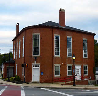
The Troy Village Historic District is a historic district encompassing the historic village center of Troy, New Hampshire, United States. The district is centered along New Hampshire Route 12, north to Marlborough Road and south to the junction with South Main Street. To the east of NH 12 it includes School Street, Mill Street, and Monadnock Street as far as Mill Street, and most of the abutting streets. On the west side it includes Russell, Water, and Prospect streets, and South Main Street nearly to Longmeadow Drive. It was listed on the National Register of Historic Places in 2002.

The East Jaffrey Historic District is a historic district running roughly along NH Route 124 through Jaffrey, New Hampshire. It encompasses what is now the economic and civic heart of the town, centered on the Jaffrey Mills and the crossing of the Contoocook River by Route 124. It extends as far west as St. Patrick's Church beyond Charlonne Street and as far east as the US Post Office building at Route 124 and Ellison Street. To the north it extends along Peterborough Street to Christian Court, and to the south it extends along River Street and School Street to their junction. The district includes early 19th-century residential structures, as well as industrial buildings and housing associated with the Jaffrey Mills which arose in the mid-19th century. The district was added to the National Register of Historic Places in 2002.
Lamson Farm is a historic farm property on Lamson Road in Mont Vernon, New Hampshire. Founded in the 1770s and operated as a farm until 1975, it is one of the few surviving intact 19th-century farm properties in the community. Its land, over 300 acres (120 ha) in size, is now town-owned conservation and farmland. The property has trails open to the public, and an annual celebration of Lamson Farm Day is held here every September. The property was added to the National Register of Historic Places in 1981.

The Chesterfield Center Historic District is a historic district that encompasses the traditional village center of the town of Chesterfield, Massachusetts. The village is reflective of the town's 18th and 19th-century development as an agrarian hill community, with architectural styles before about 1850 predominating. The district was listed on the National Register of Historic Places in 2000.
The Dublin Village Historic District encompasses the historic village center of Dublin, New Hampshire. Dublin's center developed in the 19th century after its original village center was abandoned due to harsher winter conditions nearer Dublin Pond. The district extends along Main Street from its junction with Lake Street in the west to the junction with Old County Road in the east, and includes sections of Old Common Road, Harrisville Road, and Church Street. The district was listed on the National Register of Historic Places in 1983.

The Jaffrey Center Historic District encompasses the traditional civic heart of the small town of Jaffrey, New Hampshire. The district lies to the west of the Jaffrey's main business district, extending along Main Street from Harkness Road to the Jaffrey Common, and along Thorndike Pond Road northward from Main Street. It includes the town's oldest civic buildings, and was its main center until the mills of East Jaffrey eclipsed it. The district was listed on the National Register of Historic Places in 1975.

The Lyme Center Historic District encompasses a modest crossroads and industrial village in rural Lyme, New Hampshire. The predominantly residential district stretches along Dorchester Road, on either side of its junction with Baker Hill Road. The village's rise in development started in the early 19th century as it was at a crossroads of the east-west Dorchester Road, and the north-south Baker Hill Road and Acorn Hill Road. The village grew rapidly in the 1820s, with a number of simple Greek Revival houses, and in 1830 the Baptist Church was built. The other major civic building in the village is the Lyme Academy, built in 1839, albeit with more Federal than Greek Revival styling. Grant Brook, which runs parallel to Dorchester Road, provided a source of power for the growth of small industrial efforts, including a sawmill at the corner of Dorchester and Baker Hill Roads. This industry provided a second minor building boom in the late 19th to early 20th century. Most of the houses in the district are vernacular Greek Revival or Cape in their styling; probably the most elaborate Greek Revival house is the 1857 Beal-Pike House at 41 Dorchester Road.
The Enfield Village Historic District encompasses the historic 19th century village center of Enfield, New Hampshire. The district was listed on the National Register of Historic Places in 2010. Multiple buildings of the district were added to the New Hampshire State Register of Historic Places in 2012.

The Bennington Village Historic District of Bennington, New Hampshire encompasses the 19th-century center of the village. Growth of the village followed a typical pattern for rural New Hampshire towns, based in this case around the growth in the early 19th century of the paper industry, which continues to be a significant economic force in the community. The district is centered on the junctions of Main, Center, and School Streets with Bible Hill Road and Francestown Road. The district was listed on the National Register of Historic Places in 2010.

The Lower Corner Historic District encompasses a small village center in the town of Sandwich, New Hampshire. Lower Corner is a rural village that is strung along New Hampshire Route 109 on either side of its junction with School House Road, about one mile from the main village of Center Sandwich. The village was developed relatively early in Sandwich's history, although its oldest buildings now date to the early 19th century. There are 25 contributing structures, mostly residences. There are two buildings built as stores, including one of brick; all the other buildings are wood frame. The district was listed on the National Register of Historic Places in 1986.

The Wakefield House is a historic house on New Hampshire Route 153 in the Wakefield Corner area of Wakefield, New Hampshire. The 2+1⁄2-story wood-frame house is believed to have been built c. 1785, but its exterior styling is mainly Federal in character, dating to the 1820s or later. It was used as an inn on the busy stagecoach route through town in the 19th century. It was listed on the National Register of Historic Places in 1983.
The New Ipswich Center Village Historic District encompasses the historic center of the rural town of New Ipswich, New Hampshire. The center village is the town's most densely populated area, with a history dating to the town's founding in 1735. The district extends along Turnpike Road between King and Porter Roads, and southward in a roughly triangular shape, the southern point of which is at the junction of Main Street and Willard Road. The village includes a large number of residences, which were mainly agricultural at first, but also include a number of properties built as summer resort houses in the late 19th and early 20th centuries. It also includes most of the town's historic civic buildings, including its historic town hall, and the Barrett House, now a museum property owned by Historic New England. The district was listed on the National Register of Historic Places in 1991.

The Jewell Town District of South Hampton, New Hampshire, encompasses a colonial-era industrial village with a history dating to 1687. It is centered at the junction of West Whitehall and Jewell Streets, which is just south of a bend in the Powwow River, the source of the power for the mills that were built here. The area was settled in 1687 by Thomas Jewell, and by the early 19th century included a variety of mills as well as a bog iron works. The district now includes only remnants of its industrial past, and features a collection of 18th and early-19th century residential architecture. The district was listed on the National Register of Historic Places in 1983.

The North Charlestown Historic District encompasses a 19th-century rural village in Charlestown, New Hampshire. Located about 5 miles (8 km) north of the town's center, the district includes a small cluster of buildings along New Hampshire Route 12A that is a remnant portion of a larger agricultural village. First settled in the 1750s, the oldest buildings in the district date to the 1790s, and most of the major buildings were built in the 19th century. Its economy was based on lumber and farming. The village was once considered a much larger, dispersed settlement, but construction of New Hampshire Route 11 in the 1960s separated some of the more remote parts of the village from its nucleus, which was bypassed by that construction.

The Smith's Corner Historic District is a historic district encompassing a historic 19th-century rural village center. Covering about 105.5 acres (42.7 ha), the district is centered on the junction of Main Avenue, South Road, and Chase Road in northwestern South Hampton, abutting its border with East Kingston. The village was important as a stagecoach stop. The district was listed on the National Register of Historic Places in 1983.
The Durham Historic District encompasses a portion of the original historic settlement area of Durham, New Hampshire. It extends along Newmarket Road from its northern junction with Laurel Lane to a three-way junction with Main Street and Dover Road. From there it extends along Main Street to Madbury Road. This area, known in early colonial days as the Oyster River Plantation, for the Oyster River which bisects it, was first settled in 1649. It was developed in the 18th century as a significant shipbuilding center. The district was listed on the National Register of Historic Places in 1980.

The Dorset Village Historic District encompasses a significant portion of the village center of Dorset, Vermont. Centered at the junction of Church Street, Kent Hill Road, and Vermont Route 30, the village was developed between the late 18th and early 20th centuries, and has a number of well-preserved unusual features, including sidewalks of marble from local quarries. The district was listed on the National Register of Historic Places in 1985, and was enlarged to the west in 1997.

The Burlington–Harmony Hill Roads Historic District encompasses a historic rural agricultural crossroads village in eastern Harwinton, Connecticut. Stretching mainly along Harmony Hill Road north of its junction with Burlington Road, it includes residential buildings dating from the mid-18th to late 19th centuries. The district was listed on the National Register of Historic Places in 1996.


