
The Avon Gorge is a 1.5-mile (2.5-kilometre) long gorge on the River Avon in Bristol, England. The gorge runs south to north through a limestone ridge 1.5 miles (2.4 km) west of Bristol city centre, and about 3 miles (5 km) from the mouth of the river at Avonmouth. The gorge forms the boundary between the unitary authorities of North Somerset and Bristol, with the boundary running along the south bank. As Bristol was an important port, the gorge formed a defensive gateway to the city.

Chew Valley Lake is a reservoir in Chew Stoke, Chew Valley, Somerset, England. It is the fifth-largest artificial lake in the United Kingdom, with an area of 1,200 acres (4.9 km2). The lake, created in the early 1950s, was opened by Queen Elizabeth II in 1956. It provides much of the drinking water for the city of Bristol and surrounding area, taking its supply from the Mendip Hills. Some of the lake water is used to maintain the flow in the River Chew.

Keynsham Humpy Tumps is a floristically rich acidic grassland site situated between the town of Keynsham, and the River Avon, southeast of Bristol, England.

Hunstrete Lake is a mature lake of 5 acres (20,000 m2). Two new lakes of 3.5 acres (14,000 m2) were constructed alongside in the 1990s. They are situated just to the south of the village of Hunstrete, Somerset; south of Bristol, and 7 miles (11 km) west of Bath. It is surrounded by a belt of trees, and at the north-west end this merges into Lord's Wood, Pensford.

Highgate Wood is a 28 hectare area of ancient woodland in North London, lying between East Finchley, Highgate and Muswell Hill. It was originally part of the ancient Forest of Middlesex which covered much of London, Hertfordshire and Essex and was mentioned in the Domesday Book. It lies in the London Borough of Haringey, but is owned and managed by the City of London Corporation.
The Chew Valley is an affluent area in North Somerset, England, named after the River Chew, which rises at Chewton Mendip, and joins the River Avon at Keynsham. Technically, the area of the valley is bounded by the water catchment area of the Chew and its tributaries; however, the name Chew Valley is often used less formally to cover other nearby areas, for example, Blagdon Lake and its environs, which by a stricter definition are part of the Yeo Valley. The valley is an area of rich arable and dairy farmland, interspersed with a number of villages.

Leigh Woods is a 2-square-kilometre (0.77 sq mi) area of woodland on the south-west side of the Avon Gorge, close to the Clifton Suspension Bridge, within North Somerset opposite the English city of Bristol and north of the Ashton Court estate, of which it formed a part. Stokeleigh Camp, a hillfort thought to have been occupied from the third century BC to the first century AD and possibly also in the Middle Ages, lies within the reserve on the edge of the Nightingale Valley. On the bank of the Avon, within the reserve, are quarries for limestone and celestine which were worked in the 18th and 19th centuries are now derelict.

The North Somerset Levels is a coastal plain, an expanse of low-lying flat ground, which occupies an area between Weston-super-Mare and Bristol in North Somerset, England. The River Banwell, River Kenn, River Yeo and Land Yeo are the three principal rivers draining the area.

The Frome Valley Walkway is an 18-mile (29 km) footpath which follows the River Frome from the River Avon in the centre of Bristol to the Cotswold Hills in South Gloucestershire. The path also links the Cotswold Way National Trail at one end with the Avon Walkway at the other.
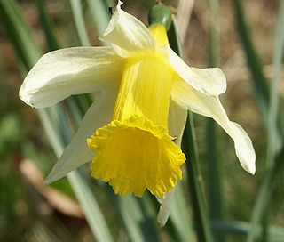
Narcissus pseudonarcissus is a perennial flowering plant.

Harptree Combe is a 13.63-hectare (33.68-acre) Site of Special Scientific Interest (SSSI) near East Harptree notified in 1954. "Combe" or "coombe" is a West Country word meaning a steep-sided valley. It is also the site of a 19th-century aqueduct and is overlooked by the site of a castle dating from around 1100.
Brown's Folly or Brown's Folly is a folly tower sitting within a 39.9 hectare biological and geological Site of Special Scientific Interest (SSSI) near the village of Bathford in Somerset, notified in 1974: the site itself is known as the Farleigh Down Stone Quarry, and is managed as a nature reserve by the Avon Wildlife Trust (AWT). The tower was built in 1848 and is a Grade II listed building.

Cleaves Wood is a 40.38 hectare biological Site of Special Scientific Interest (SSSI) near the village of Wellow in Bath and North East Somerset, notified in 1988.
Goblin Combe is a dry valley in North Somerset which stretches for approximately 3½ km from Redhill, near Bristol International Airport on the A38, through to Cleeve on the A370. The combe is located at, and is a 52-hectare (128-acre) biological Site of Special Scientific Interest (SSSI) originally notified in 1999, with 9 hectares being managed as a nature reserve by the Avon Wildlife Trust. The Combe runs along the southern edge of a large woodland. "Combe" is the same as the Welsh word "cwm" which means valley.
Weston Big Wood is a 37.48 hectare woodland west of the town of Portishead, North Somerset, England. It is a nature reserve and biological Site of Special Scientific Interest, notified in 1971. The wood takes its name from the nearby village of Weston-in-Gordano.

Max Bog is a 10.6 hectare biological Site of Special Scientific Interest in North Somerset, notified in 1988.

The wildlife of Azerbaijan consists of its flora and fauna and their natural habitats.

Skipton Wood is a 36-acre (15 ha) wood following the valley of Eller Beck to the north of Skipton behind Skipton Castle in North Yorkshire, England. The wood is owned by Skipton Castle but has been leased to the Woodland Trust.
There are several nature reserves in the surroundings of Nailsea, North Somerset, England, which is located at 51°25′55″N2°45′49″W.

Sand Point in Somerset, England, is the peninsula stretching out from Middle Hope, an 84.1-hectare (208-acre) biological and geological Site of Special Scientific Interest. It lies to the north of the village of Kewstoke, and the stretch of coastline called Sand Bay north of the town of Weston-super-Mare. On a clear day it commands views over Flat Holm, of the Bristol Channel, South Wales, Clevedon, the Second Severn Crossing and the Severn Bridge. A line drawn between Sand Point and Lavernock Point in South Wales marks the lower limit of the Severn Estuary and the start of the Bristol Channel.

