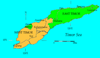
West Timor is an area covering the western part of the island of Timor, except for the district of Oecussi-Ambeno. Administratively, West Timor is part of East Nusa Tenggara Province, Indonesia. The capital as well as its main port is Kupang. During the colonial period, the area was named Dutch Timor and was a centre of Dutch loyalists during the Indonesian National Revolution (1945–1949). From 1949 to 1975 it was named Indonesian Timor.

Portuguese Timor was a colonial possession of Portugal that existed between 1702 and 1975. During most of this period, Portugal shared the island of Timor with the Dutch East Indies.

Tetum is an Austronesian language spoken on the island of Timor. It is one of the official languages of Timor-Leste and it is also spoken in Belu Regency and Malaka Regency, which form the eastern part of Indonesian West Timor adjoining Timor-Leste.

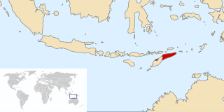
East Timor, officially the Democratic Republic of Timor-Leste, is a country in Southeast Asia and Oceania. The country comprises the eastern half of the island of Timor and the nearby islands of Atauro and Jaco. The first inhabitants are thought to be descendant of Australoid and Melanesian peoples. The Portuguese began to trade with Timor by the early 16th century and colonised it throughout the mid-century. Skirmishing with the Dutch in the region eventually resulted in an 1859 treaty for which Portugal ceded the western half of the island. Imperial Japan occupied East Timor during World War II, but Portugal resumed colonial authority after the Japanese surrender.

Atauro, also known as Kambing Island, is an island and municipality of East Timor. Atauro is a small oceanic island situated north of Dili, on the extinct Wetar segment of the volcanic Inner Banda Arc, between the Indonesian islands of Alor and Wetar. The nearest island is the Indonesian island of Liran, 13.0 km (8.1 mi) to the northeast. At the 2015 census, it had 9,274 inhabitants.

The National University of East Timor, is a public university in East Timor, the only one of its kind in the country.
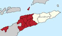
East Timor was a province of Indonesia between 1976 and 1999, during the Indonesian occupation of the country. Its territory corresponded to the previous Portuguese Timor and to the present-day independent country of East Timor.

The Kemak people are an ethnic group numbering 80,000 in north-central Timor island. They primarily live in the district of Bobonaro, East Timor, while the rest live in the East Nusa Tenggara province of Indonesia.
The Armed Forces for the National Liberation of East Timor originally began as the military wing of the Fretilin party of East Timor. It was established on 20 August 1975 in response to Fretilin's political conflict with the Timorese Democratic Union (UDT).

The Indonesian invasion of East Timor, known in Indonesia as Operation Lotus, began on 7 December 1975 when the Indonesian military (ABRI/TNI) invaded East Timor under the pretext of anti-colonialism and anti-communism to overthrow the Fretilin regime that had emerged in 1974. The overthrow of the popular and short-lived Fretilin-led government sparked a violent quarter-century occupation in which approximately 100,000–180,000 soldiers and civilians are estimated to have been killed or starved to death. The Commission for Reception, Truth and Reconciliation in East Timor documented a minimum estimate of 102,000 conflict-related deaths in East Timor throughout the entire period from 1974 to 1999, including 18,600 violent killings and 84,200 deaths from disease and starvation; Indonesian forces and their auxiliaries combined were responsible for 70% of the killings.
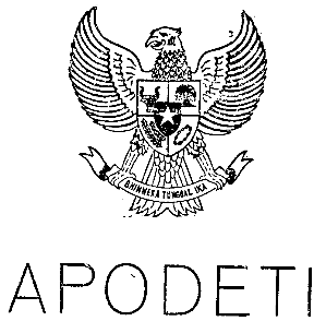
The Timorese Popular Democratic Association was a political party in East Timor established in 1974, which advocated for integration into Indonesia. Along with another East Timor party, the Timorese Democratic Union (UDT), it signed the Balibo Declaration in 1975 calling for Indonesia to annex the region. The party led the Provisional Government of East Timor that was formed following the Indonesian invasion of East Timor later that year. Since 2000, the party used the suffix Pro-Referendo (Pro-referendum). A renaming to Partido Democrata Liberal was considered. The party is said to have been dissolved.

Timor-Leste, also known as East Timor, officially the Democratic Republic of Timor-Leste, is a country in Southeast Asia. It comprises the eastern half of the island of Timor, the exclave of Oecusse on the island's north-western half, and the minor islands of Atauro and Jaco. The western half of the island of Timor is administered by Indonesia. Australia is the country's southern neighbour, separated by the Timor Sea. The country's size is 14,950 square kilometres (5,770 sq mi). Dili, on the north coast of Timor, is its capital and largest city.
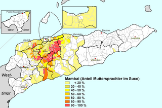
Mambai, also called Mambae or Manbae, is a language spoken by the Mambai people, the second largest ethnic group in the island country of East Timor.

Chinese people in East Timor consist of Chinese migrants to East Timor and their descendants. The Chinese minority is a small proportion of the East Timorese population and most are Hakka and a small number of Cantonese within the populace. Many Chinese left during the mid-1970s.

The 1959 Viqueque rebellion was an uprising against the Portuguese rule in the southeastern part of East Timor. It was concentrated in the remote regions of Uatolari and Uatocarbau. It was an anti-colonial rebellion against the Portuguese, who had been the colonial masters of East Timor since the sixteenth century. The rebellion is significant in East Timorese history because it was the only rebellion that erupted after World War II. For the longest time, due to lack of information and research, there were speculations and assumptions made about the origins of the rebellion which focus more on external factors, like the role of Indonesia. However, in the last decade, there has been more research done that has helped to illuminate this part of East Timor's history and it has also highlighted the agency of the East Timorese for participating in the rebellion.

Aurélio Sérgio Cristóvão Guterres is an East Timorese academic and politician, and a member of the Fretilin political party. From September 2017 to June 2018, he was Minister for Foreign Affairs and Cooperation in the VII Constitutional Government of East Timor led by Mari Alkatiri.

Timorese wedding traditions apply to marriages on the island of Timor, which is divided between Indonesia and East Timor. The wedding traditions are still followed in about half of all marriages in East Timor. Ever since colonial times, there has been heated debate about the value of these traditions and the role of women in them.

The Democratic Republic of East Timor, was a state that was unilaterally proclaimed on the territory of present-day East Timor on 28 November 1975 by Fretilin prior to the Indonesian invasion of East Timor nine days later on 7 December 1975.

Loro Sae is the name of the eastern part of East Timor. This leads to confusion, as the official name of the country in the official language Tetum is "Timór Loro Sa'e". Loro Sae means rising sun or simply east. The inhabitants of Loro Sae are called Firaku, regardless of their other ethnic affiliations. In contrast, the western part of the country is called Loro Munu and its inhabitants Kaladi. The country's capital, Dili, is a melting pot of the country's different ethnic groups and is the scene of regular street fights between gangs from the east and the west.
In August 1975, a civil war broke out between two opposing political parties in Portuguese Timor: the conservative Timorese Democratic Union (UDT) and the left-leaning Revolutionary Front for an Independent East Timor (Fretilin). The war took place within the context of decolonisation, as the post–Carnation Revolution Portuguese government sought to give independence to much of the Portuguese Empire. UDT and Fretilin were formed in May 1974, following the legalisation of political parties in Portugal. UDT initially advocated for continuing ties to Portugal, before shifting to promoting a gradual independence process that maintained existing institutions. Fretilin sought independence with a new political system that would address a widespread lack of development in the territory. Also formed during this time was the Timorese Popular Democratic Association (Apodeti), which advocated for an Indonesian annexation of the territory, although Apodeti gained far less popular support than the other two major parties.