Los Alamos Canyon Creek

Last updated
Los Alamos Canyon Creek [1]
Los Alamos Canyon
SanMateoCreekArroyoSanOnofre.jpg
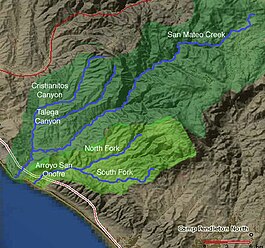
Map of San Mateo Creek and Arroyo San Onofre drainage basins. San Mateo Creek basin is in dark green.
Location
Country United States
State California
Region Riverside County
Physical characteristics
Sourcesoutheastern slope of Elsinore Mountains
  coordinates 33°35′39″N117°19′05″W / 33.59417°N 117.31806°W / 33.59417; -117.31806
  elevation2,300 ft (700 m)
Mouth confluence with San Mateo Creek
  coordinates
33°33′04″N117°23′38″W / 33.55111°N 117.39389°W / 33.55111; -117.39389 Coordinates: 33°33′04″N117°23′38″W / 33.55111°N 117.39389°W / 33.55111; -117.39389
  elevation
1,312 ft (400 m)
Length7 mi (11 km)
Discharge 
  locationconfluence with San Mateo Creek, Santa Ana Mountains
Basin features
Tributaries 
  leftunnamed arroyo from Tenaja Mountain highland & Santa Rosa Plateau
  rightunnamed arroyo from Elsinore Mountains, below Elsinore Peak., Wildhorse Canyon Creek, unnamed arroyo from San Mateo Peak

Los Alamos Canyon Creek, a stream or arroyo, tributary to San Mateo Creek, in the Cleveland National Forest in Riverside County, California. Its source is at an altitude of 2300 feet, in a canyon on the south face of the ridge of Elsinore Mountains that descends to the southeast from Elsinore Peak. [2] The creek descends southward for a short distance then turns southwest for 4 miles where it turns west for 3 miles down Los Alamos Canyon to its confluence with San Mateo Creek at an elevation of 1312 feet. [3] [4]

Los Alamos Canyon Creek has one named tributary Wildhorse Canyon Creek [5] but has two unnamed arroyos descending from the Elsinore Mountains. [6] [7] and one that drains the western Santa Rosa Plateau and the east slope of the Tenaja Mountain highland and descends to the north to join the creek where it turns to the west. [8]

Related Research Articles

Horno Creek is a creek that empties into the Pacific Ocean through Horno Canyon on the coast of northern San Diego County on the Marine Corps Base Camp Pendleton. It lies south of Foley Creek and north of Las Flores Creek.

<span class="mw-page-title-main">San Mateo Creek (Southern California)</span> River in California, United States

San Mateo Creek is a stream in Southern California in the United States, whose watershed mostly straddles the border of Orange and San Diego Counties. It is about 22 miles (35 km) long, flowing in a generally southwesterly direction. Draining a broad valley bounded by the Santa Ana Mountains and Santa Margarita Mountains, San Mateo Creek is notable for being one of the last unchannelized streams in Southern California.

Temescal Creek (Riverside County) River in the United States

Temescal Creek is an approximately 29-mile-long (47 km) watercourse in Riverside County, in the U.S. state of California. Flowing primarily in a northwestern direction, it connects Lake Elsinore with the Santa Ana River. It drains the eastern slopes of the Santa Ana Mountains on its left and on its right the western slopes of the Temescal Mountains along its length. With a drainage basin of about 1,000 square miles (2,600 km2), it is the largest tributary of the Santa Ana River, hydrologically connecting the 720-square-mile (1,900 km2) San Jacinto River and Lake Elsinore watersheds to the rest of the Santa Ana watershed. However, flowing through an arid rain shadow zone of the Santa Ana Mountains, and with diversion of ground water for human use, the creek today is ephemeral for most of its length, except for runoff from housing developments and agricultural return flows.

Coleman Creek in San Diego County, California is a tributary of the San Diego River that arises at the top of the valley running southeasterly from Julian, at a saddle between two ridges of the Cuyamaca Mountains just south of Kentwood-In-The-Pines. From there, Coleman Creek descends northwesterly down the valley to Julian, where it turns west, descending its canyon northwesterly through the site of Branson City, past the mouth of its tributary Eastwood Creek on the north, passing through the south end of Spencer Valley, past the mouth of its tributary Baily Creek on the north, then descending northwest down Quanai Canyon to its confluence with the San Diego River.

Eastwood Creek in San Diego County, California, is a tributary of Coleman Creek that arises in the Cuyamaca Mountains, at the north face of the gold bearing mountain north of Julian. From the source Eastwood Creek descends northwesterly a short distance, then turns southwest down a canyon to its confluence with Coleman Creek, just below the site of Branson City.

Rancho Potrero de la Cienaga is one of the three ranchos that made up the Rancho Potreros de San Juan Capistrano. Its boundary included in the spring watered mountain valley pastures of Round Potrero and Potrero de la Cienaga, in the upper reach of San Mateo Creek in the Santa Ana Mountains in the present day Cleveland National Forest in western Riverside County, United States.

San Mateo Peak

San Mateo Peak is the unofficially named 3,591-foot (1,095 m) peak, at the western end of the ridge running west then northwest from Elsinore Peak to Morrell Canyon, south and west of the Morrell Potrero in the Elsinore Mountains of the Santa Ana Mountain Range. The peak name was given by Sierra Club Lower Peaks Committee Guide, originally named by Ken Croker who for 20 years maintained trails in the Santa Ana Mountains with volunteers from the Sierra Club. It remains officially nameless despite being the highest summit in the Elsinore Mountains, higher than Elsinore Peak, at 3536 ft., the highest named peak in those mountains.

<span class="mw-page-title-main">Elsinore Mountains</span>

The Elsinore Mountains are a ridge of mountains within the larger range of the Santa Ana Mountains, in the Cleveland National Forest, Riverside County, California, United States. the tallest peaks within the range is the unofficially named San Mateo Peak at 3,591 ft (1,095 m). Second is officially named Elsinore Peak at 3,536 ft (1,078 m). The Elsinore Mountanins run in a ridge from just east of El Cariso, southeast to Elsinore Peak. Beyond that peak the ridge begins to descend and curves to the east. From Elsinore Peak, a ridge runs to the west and then northwest to San Mateo Peak, enclosing the Morrell Potrero on the south and west.

Morrell Potrero is a flat located in the Cleveland National Forest in Riverside County, California. It has an elevation of approximately 3,041 ft (927 m) in the Elsinore Mountains northwest of Elsinore Peak. It is drained by Morrell Canyon Creek, a tributary of San Juan Creek.

Morrell Canyon Creek River in California, United States

Morrell Canyon Creek is a stream or Arroyo, tributary to San Juan Creek, located in the Cleveland National Forest in Riverside County, California, at an elevation of 3,080 ft (939 m), in the Elsinore Mountains northeast of Elsinore Peak. It arises on the eastern slope of San Mateo Peak. An eastern fork draining the Morrell Potrero joins it a little over a mile north of its source and then flows northwestward about a third of a mile where it turns southeast descending the narrow Morrell Canyon east of Lion Spring. After descending 2.5 miles it turns north for half a mile then returns to a southwestern direction for another mile, the canyon widening here until it turns northwestward and down a steep canyon again for half a mile where it takes in from the right Decker Canyon Creek and Long Canyon Creek. It then turns southwestward again into a wider canyon and descends to its confluence with Bear Canyon Creek and becomes the head of San Juan Creek.

Rancho Capistrano, is a private, gated community surrounded by the Cleveland National Forest, in Riverside County, California.

<span class="mw-page-title-main">Tenaja Canyon Creek</span> River in California, United States

Tenaja Canyon Creek, a stream or arroyo, tributary to San Mateo Creek, in the Cleveland National Forest in Riverside County, California. Its source is at an altitude of 1875 feet. The creek has its source at the confluence of arroyos from El Potrero del Tenaja, Redonda Mesa and Tenaja Mountain highlands. and it flows northwestward 3+12 miles down Tenaja Canyon to its mouth and its confluence near Fishermans Camp, at an elevation of 1112 feet with San Mateo Creek. The word may refer to the arroyo El Portero del Tenaja or to the topographic structure.

Devil Canyon Creek River in California, United States

Devil Canyon Creek, a stream or arroyo, tributary to San Mateo Creek, in the Santa Margarita Mountains, all but its first and last part within the Cleveland National Forest in San Diego County, California. Its source is at an altitude of 2440 feet on a flat private land in the Santa Margarita Mountains. and it flows southwestward then turns down into the canyon and the San Mateo Wilderness and northward 2 miles before turning westward toward its confluence in San Mateo Canyon with San Mateo Creek at an elevation of 453 feet. The last half mile of the creek before this confluence is outside the National Forest boundary, and within the Camp Pendleton Marine Corps Base. Devil Canyon has one named tributary, Cold Spring Canyon Creek, draining the Santa Margarita Mountains north of the Devil Canyon watershed that enters it from the right about a mile and half above the confluence of Devil Canyon Creek with San Mateo Creek.

Cristianitos Creek River in California, United States

Cristianitos Canyon Creek, a stream or arroyo, tributary to San Mateo Creek, in the Santa Ana Mountains. its source is within Orange County, California. Its source is at an altitude of 800 feet, at the head of Cristianitos Canyon, in the foothills of the Santa Ana Mountains, in Orange County. It flows southwestward down Cristianitos Canyon, then turns south towards its confluence with San Mateo Creek, at an elevation of 75 feet, in San Diego County.

Temescal Mountains, also known as the Sierra Temescal, are one of the northernmost mountain ranges of the Peninsular Ranges in western Riverside County, in Southern California in the United States. They extend for approximately 25 mi (40 km) southeast of the Santa Ana River east of the Elsinore Fault Zone to the Temecula Basin and form the western edge of the Perris Block.

Warm Springs Valley is a valley located within the city of Lake Elsinore in Riverside County, California. It lies between the main body of the Temescal Mountains to the north, east and south and the Clevelin Hills to the west. The valley was named for the warm springs that used to be found flowing there.

Gavilan Hills, sometimes called the Gavilan Mountains, are a range of the Temescal Mountains, in Riverside County, California. The name given them came from local New Mexican and Californio miners of the mountains and Gavilan Plateau. In Spanish Gavilan, means "sparrow hawk".

Cajalco Canyon Creek is an ephemeral stream that flows through Cajalco Canyon in the Temescal Mountains of Riverside County, California, United States. It is a tributary to Temescal Wash, itself a tributary to the Santa Ana River. Cajalco is thought to be a Hispanic spelling of the word for "quail" in the languages of the Luiseño and Cahuilla who lived in the area. The meaning of the word Cajalco is an anagram meaning California Jalisco Land Company of Los Angeles

Alberhill Canyon, is an informally named valley and arroyo in the Temescal Mountains of Riverside County, California. It is named for the former mining settlement and populated place of Alberhill that lay opposite the mouth of the arroyo at its confluence with Temescal Creek.

References