
The St. Lawrence Seaway is a system of locks, canals, and channels in Canada and the United States that permits oceangoing vessels to travel from the Atlantic Ocean to the Great Lakes of North America, as far inland as Duluth, Minnesota, at the western end of Lake Superior. The seaway is named for the St. Lawrence River, which flows from Lake Ontario to the Atlantic Ocean. Legally, the seaway extends from Montreal, Quebec, to Lake Erie, and includes the Welland Canal.

The United Counties of Stormont, Dundas and Glengarry, shortened to SDG, is an upper-tier municipality in the Canadian province of Ontario that comprises three historical counties and excludes the City of Cornwall and the Mohawk Nation of Akwesasne. However, both Cornwall and Akwesasne form part of a larger census division named for the United Counties of Stormont, Dundas and Glengarry. The municipality's administrative office is located within Cornwall.

Aultsville is a ghost town in the Canadian province of Ontario. It is one of Ontario's Lost Villages, which were permanently flooded by the creation of the St. Lawrence Seaway in 1958. The town was founded as Charlesville in 1787 by United Empire Loyalists and reached its peak in 1880, when it had 400 residents. It was the second largest town flooded by the new Seaway in 1958, with a population of 312 at the time. Before it was flooded, the abandoned buildings were burned to study the effects of fire on houses.

Dickinson's Landing is an underwater ghost town in the Canadian province of Ontario. It is one of Ontario's Lost Villages, which were permanently flooded by the creation of the St. Lawrence Seaway in 1958.
Wales is a ghost town in the Canadian province of Ontario. It is one of Ontario's Lost Villages, which were permanently flooded by the creation of the St. Lawrence Seaway in 1958. The town was named for the Prince of Wales who visited the area during his Canadian tour of 1860. Wales was built on the land grant of Dr. James Stuart, of the King’s Royal Regiment of New York. From 1810 to 1957, five generations of the Stuart family lived on this property.
Mille Roches is an underwater ghost town in the Canadian province of Ontario. It is one of Ontario's Lost Villages, which were permanently flooded by the creation of the St. Lawrence Seaway in 1958.

Moulinette, Ontario is an underwater ghost town in the Canadian province of Ontario. It is one of Ontario's Lost Villages, which were permanently flooded by the creation of the St. Lawrence Seaway in 1958. Families and businesses in Moulinette were moved to the new town of Long Sault before the seaway construction commenced. The village was located as a strip community along Highway 2, on the St. Lawrence River. At the time of the flooding, Moulinette had a population of around 311 residents. The community would have been located in what is now South Stormont township.

Ault Park is a park on the St. Lawrence River in the Township of South Stormont, near Long Sault, Ontario, Canada.
Levi Addison Ault was a Canadian-born American businessman and bureaucrat whose career was closely associated with the city of Cincinnati, Ohio, where he earned the nickname "Father of Cincinnati's parks".
Sheek Island is an island in the St. Lawrence River in the Canadian province of Ontario. It is considered to be one of Ontario's Lost Villages, which were permanently flooded by the creation of the St. Lawrence Seaway in 1958. While much of the island has been flooded, a portion of it remains above water, but is not populated.
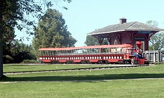
Upper Canada Village is a heritage park near Morrisburg, Ontario, which depicts a 19th-century village in Upper Canada.

Long Sault was a rapid in the St. Lawrence River upstream and west of Cornwall, Ontario. Sault is the archaic spelling of the French word saut, meaning rapids.
South Dundas is a municipality in eastern Ontario, Canada, in the United Counties of Stormont, Dundas and Glengarry along the north shore of the St. Lawrence River. It is located approximately 100 kilometres south of Ottawa and is midway between Kingston and Montreal, Quebec.
South Stormont is a township in eastern Ontario, Canada, in the United Counties of Stormont, Dundas and Glengarry. It is located 53 kilometres (33 mi) southeast of Ottawa. South Stormont borders on, but does not include, the city of Cornwall.
The Long Sault Parkway is a 10.1-kilometre (6.3 mi) scenic parkway connecting a group of eleven islands west of Cornwall in the Canadian province of Ontario. The islands, which were created by the flooding of the Long Sault rapids during construction of the St. Lawrence Seaway in the late 1950s, include two public beaches and three campgrounds. A road also known as the Long Sault Parkway serves to interconnect the islands. The parkway, the islands, and their amenities are maintained by the St. Lawrence Parks Commission.

The St. Lawrence Parks Commission is a Crown agency of the Government of Ontario that manages parks and heritage sites along the shoreline of the St. Lawrence River in southeastern Ontario. It functions similarly to the Niagara Parks Commission's role in overseeing attractions and conservation on the Ontario side of the Niagara River.
The Stormont, Dundas and Glengarry County Library, Ontario, Canada, was established in 1971, the SD&G County Library grew from the merger of seven existing libraries located in a number of small rural communities of Eastern Ontario, Canada: Lancaster, Ingleside, Newington, Morrisburg, Chesterville, Winchester and South Mountain. Added in the same year were branches in Maxville and Alexandria, followed by Long Sault (1972); Crysler (1973); Moose Creek, Avonmore, St. Andrews, Williamstown (1975); Brinston (1976–1998); Finch (1978) and Dalkeith (1978-2016); Williamsburg (1979); Morewood (1986-2016); Glen Robertson (1988–1998); Lancaster Township (1992–2001); and Iroquois (1998).

The Moses-Saunders Power Dam, short for Robert Moses-Robert H. Saunders Power Dam, is a dam on the Saint Lawrence River straddling the border between the United States and Canada. It is located between Massena in New York and Cornwall in Ontario. The dam supplies water to two adjacent hydroelectric power generating stations, the United States' 912 MW St. Lawrence-Franklin D. Roosevelt Power Project and Canada's 1,045 MW R.H. Saunders Generating Station. Constructed between 1954 and 1958 as part of the larger Saint Lawrence Seaway project, the dam created Lake St. Lawrence. Aside from providing significant amounts of renewable power, the dam regulates the St. Lawrence River and affords passage for the navigation of large vessels. Despite the enormous economic advantages to the dam, it required the relocation of 6,500 people and caused harm to the surrounding environment. Positive efforts have been made over the years to improve shoreline and fish habitats.
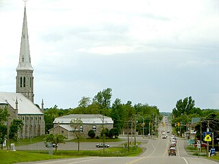
Morrisburg is an unincorporated community in the Municipality of South Dundas, located in Eastern Ontario, Canada.
Save Ontario Shipwrecks (SOS) is a Provincial Heritage Organization in Ontario, Canada. SOS is a public charitable organization which operates through Local Chapter Committees supported by a Provincial Board of Directors and Provincial Executive.


