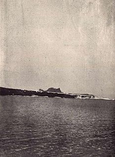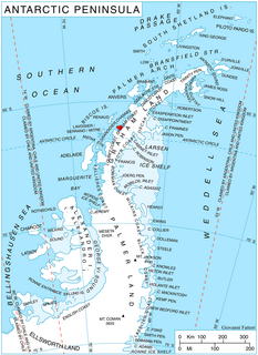
James Ross Island is a large island off the southeast side and near the northeastern extremity of the Antarctic Peninsula, from which it is separated by Prince Gustav Channel. Rising to 1,630 metres (5,350 ft), it is irregularly shaped and extends 64 km in a north–south direction. It was charted in October 1903 by the Swedish Antarctic Expedition under Otto Nordenskiöld, who named it for Sir James Clark Ross, the leader of a British expedition to this area in 1842 that discovered and roughly charted a number of points along the eastern side of the island. The style, "James" Ross Island is used to avoid confusion with the more widely known Ross Island in McMurdo Sound.

The Usarp Mountains is a major Antarctic mountain range, lying westward of the Rennick Glacier and trending N-S for about 190 kilometres (118 mi). The feature is bounded to the north by Pryor Glacier and the Wilson Hills. Its important constituent parts include Welcome Mountain, Mount Van der Hoeven, Mount Weihaupt, Mount Stuart, Mount Lorius, Smith Bench, Mount Roberts, Pomerantz Tableland, Daniels Range, Emlen Peaks, Helliwell Hills and Morozumi Range.

Mount Shackleton is a mountain, 1,465 m, with perpendicular cliffs facing west, standing 2.5 miles (4.0 km) east of Chaigneau Peak between Leay and Wiggins Glaciers on Kiev Peninsula, the west side of Graham Land in Antarctica. It was discovered by the 1908–10 French Antarctic Expedition under Charcot and named by him for Sir Ernest Shackleton.

Foyn Island, also known as Svend Foyn Island, is the second largest island in the Possession Islands, East Antarctica, lying 6 kilometres (4 mi) south-west of Possession Island. An Adélie penguin rookery covers much of the island, which is often included in the itinerary of Antarctic cruises.

Aspland Island is a small island 7.4 km (4 nmi) west of Gibbs Island in the South Shetland Islands of Antarctica. The name dates back to at least 1821.

Lawrie Glacier is a glacier flowing between Mount Genecand and Mezzo Buttress, and entering the head of Barilari Bay between Cherkovna Point and Prestoy Point on the west coast of Graham Land, Antarctica. It was charted by the British Graham Land Expedition under Rymill, 1934–37, and was named by the UK Antarctic Place-Names Committee in 1959 for Robert Lawrie, an English alpine and polar equipment specialist.

Bagshawe Glacier is a glacier which drains the northeast slopes of Mount Theodore and discharges into Lester Cove, Andvord Bay west of Mount Tsotsorkov, on the west coast of Graham Land, Antarctica.

Noville Peninsula is a high ice-covered peninsula about 30 nautical miles (60 km) long, between Peale and Murphy Inlets on the north side of Thurston Island in Antarctica. Delineated from aerial photographs made by U.S. Navy Operation Highjump in December 1946. Named for George O. Noville, executive officer of Byrd Antarctic Expedition, 1933-35.
Monflier Point is a point which marks the southwest end of Rabot Island in the Biscoe Islands of Antarctica. It was first charted and named by the Fourth French Antarctic Expedition, 1908–10, under Jean-Baptiste Charcot.

Goldsmith Glacier is a glacier flowing west-northwest through the Theron Mountains of Antarctica, 6 nautical miles (11 km) south of Tailend Nunatak. It was first mapped in 1956–57 by the Commonwealth Trans-Antarctic Expedition (CTAE) and named for Rainer Goldsmith, medical officer with the advance party of the CTAE in 1955-56.

González Anchorage is an anchorage in the Duroch Islands of Antarctica, on the west side of Kopaitic Island. The anchorage was charted by the Chilean Antarctic Expedition of 1948, which gave the name after Capitan de Fragata Ernesto González Navarrete, the commander of the expedition.

Hoek Glacier is a glacier flowing into Dimitrov Cove northeast of Veshka Point on the northwest coast of Velingrad Peninsula on Graham Coast in Graham Land, Antarctica, southward of the Llanquihue Islands. It was charted by the British Graham Land Expedition under John Rymill, 1934–37, and was named by the UK Antarctic Place-Names Committee in 1959 for Henry W. Hoek (1878–1951), a pioneer Swiss ski-mountaineer and author of one of the earliest skiing manuals.
Hervéou Point is a point forming the western extremity of the rocky peninsula between Port Charcot and Salpetriere Bay, on the west side of Booth Island in the Wilhelm Archipelago, Antarctica. It was first charted by the French Antarctic Expedition, 1903–05, under Jean-Baptiste Charcot, and named by him for F. Hervéou, a seaman on the Français.

Sonia Point is a point lying 6 miles west of Rahir Point on the south side of Flandres Bay, on the northeast coast of Kiev Peninsula, Graham Land. It is 1 mile north of Reade Peak. First charted by the French Antarctic Expedition under Charcot, 1903–05, and named for Madame Sonia Bunau-Varilla.

Rahir Point is a point marking the northeast end of a small peninsula which extends into Flandres Bay just north of Thomson Cove, on the northeast coast of Kiev Peninsula, Graham Land. First charted by the Belgian Antarctic Expedition under Gerlache, 1897–99, and named "Cap Rahir," probably for Maurice Rahir, Belgian geographer and member of the Belgian Royal Geographical Society.
Labbé Rock is a rock lying about 0.7 nautical miles (1.3 km) northwest of Largo Island in the Duroch Islands of Antarctica. The name was conferred by the first Chilean Antarctic Expedition (1947) for First Lieutenant Custodio Labbé Lippi, navigation officer of the transport ship Angamos.
Landmark Point is a rocky point lying 1 kilometre (0.5 nmi) southeast of Safety Island, on the coast of Mac. Robertson Land, Antarctica. It was mapped from Australian National Antarctic Research Expeditions surveys and air photos, 1956–66, and was so named by the Antarctic Names Committee of Australia because it is almost due south from Auster Rookery and affords an excellent landmark if approaching the rookery along the coast from Mawson Station.
Lavallee Peak is a peak 2,175 metres (7,140 ft) high just northwest of Gibraltar Peak in the West Quartzite Range of Antarctica. It was mapped by the United States Geological Survey from surveys and U.S. Navy air photos, 1960–64, and was named by the Advisory Committee on Antarctic Names for Lieutenant David O. Lavallee, U.S. Navy, a biological diver at McMurdo Station during the summers of 1963–64, 1964–65 and 1966–67.
Libois Bay is a cove on the west side of Cholet Island which is entered between Rozo Point, the northwest end of Cholet Island, and Paumelle Point, the northwest end of Booth Island, in the Wilhelm Archipelago, Antarctica. It was first charted by the French Antarctic Expedition, 1903–05, and named by Jean-Baptiste Charcot for F. Libois, second mechanic and carpenter of the ship Français.


