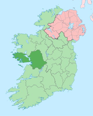
County Galway is a county in Ireland. It is in the Northern and Western Region, taking up the south of the province of Connacht. The county population was 276,451 at the 2022 census.

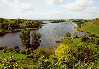
Lough Corrib is a lake in the west of Ireland. The River Corrib or Galway River connects the lake to the sea at Galway. It is the largest lake within the Republic of Ireland and the second largest on the island of Ireland. It covers 176 km² and lies mostly in County Galway with a small area of its northeast corner in County Mayo.

Lough Neagh is a freshwater lake in Northern Ireland and is the largest lake on the island of Ireland and in the United Kingdom. It has a surface area of 151 square miles and is about 19 miles (31 km) long and 9 miles (14 km) wide. According to Northern Ireland Water, it supplies 40.7% of Northern Ireland's drinking water. Its main inflows are the Upper River Bann and Blackwater, and its main outflow is the Lower Bann. There are several small islands, including Ram's Island, Coney Island and Derrywarragh Island. The lake bed is owned by the 12th Earl of Shaftesbury and the lake is managed by Lough Neagh Partnership. Its name comes from Irish Loch nEachach, meaning "Eachaidh's lake".

Lough Owel is a mesotrophic lough in the Midlands of Ireland, situated north of Mullingar, the county town of Westmeath. It has a maximum depth of 21 metres (69 ft). Water from Lough Owel feeds the Royal Canal, a canal crossing Ireland from Dublin to the River Shannon. The lake is close to the N4 primary road.

Loughrea is a town in County Galway, Ireland. The town lies to the north of a range of wooded hills, the Slieve Aughty Mountains, and Lough Rea, the lake from which it takes its name. The town's cathedral, St Brendan's, dominates the urban skyline.

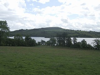
Lough Derg, historically Lough Dergart, is a freshwater lake in the Shannon River Basin, Ireland. It is the third-biggest on the island of Ireland and the second largest lake in the Republic of Ireland.

Lough Mask is a limestone lake of about 83 km2 (32 sq mi) in Counties Mayo and Galway, Ireland, north of Lough Corrib. Lough Mask is the middle of the three lakes, which empty into the Corrib River, through Galway, into Galway Bay. Lough Carra flows into Lough Mask, which discharges through the Cong Canal and underground passages in the limestone bedrock of the district. The flows from the underground passages and the Cong Canal come together at the village of Cong to form the River Cong which flows into Lough Corrib.
Lough Gur is a lake in County Limerick, Ireland between the towns of Herbertstown and Bruff. The lake forms a horseshoe shape at the base of Knockadoon Hill and some rugged elevated countryside. It is one of Ireland's most important archaeological sites. Humans have lived near Lough Gur since about 3000 BC and there are numerous megalithic remains there.
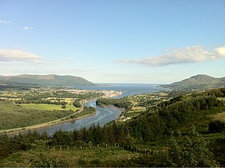
Carlingford Lough is a glacial fjord or sea inlet in northeastern Ireland, forming part of the border between Northern Ireland to the north and the Republic of Ireland to the south. On its northern shore is County Down, the Mourne Mountains, and the town of Warrenpoint; on its southern shore is County Louth, the Cooley Mountains and the village of Carlingford. The Newry River flows into the loch from the northwest.

Lough Bane is a lake on the border of County Meath and County Westmeath in Ireland. The county border runs east–west through the centre of the lake.

Lough Sheelin, in standard Irish Loch Síleann, is a limestone freshwater lough (lake) in central Ireland. The lake is a part of the River Inny course, and ultimately of the Shannon system.

Lough Gara is a lake in Counties Sligo and Roscommon, Ireland. It is an Important Bird Area protecting 1,788 ha of which most is covered by a Ramsar Site.

Lough Talt is a lake in the Ox Mountains of south County Sligo, Ireland. The lake is located between the villages of Tubbercurry and Bonniconlon on the R294 road. Lough Talt is part of the Lough Hoe Bog Special Area of Conservation, an area of montane bogland and oligotrophic lakes.

Lough Arrow is a freshwater lake in the northwest of Ireland. This large, scenic lake covers an area of 12.47 square kilometres (4.8 sq mi) and lies mostly in County Sligo with a smaller part in County Roscommon. It is a popular trout fishing lake.

Templehouse Lough is a freshwater lake in the northwest of Ireland. It is located in south County Sligo and forms part of the course of the Owenmore River.
Lough Scur is a freshwater lake in south County Leitrim, northwest Ireland. It is part of the Shannon–Erne Waterway. There have been Human settlements here since the New Stone Age. Modern features include quays and moorings. Protected features are Castle John, three Crannogs, and the causeway into Rusheen Island, though "Jail Island" is not protected. The ecology of Lough Scur, and indeed all county Leitrim lakes, is threatened by pollution and invasive species such as curly waterweed, zebra mussel, and freshwater clam.

Lough Beagh, also known as Lough Veagh, is a freshwater lake in the northwest of Ireland. It is located in north County Donegal and is part of Glenveagh National Park.
Lough Fern is a freshwater lake in the northwest of Ireland. It is located in north County Donegal near the town of Milford.

Kindrum Lough is a freshwater lake in the northwest of Ireland. It is located in north County Donegal on the Fanad Peninsula.
Annaghmore Lough is a freshwater lake in the west of Ireland. It is located in County Roscommon in the catchment of the upper River Shannon.

