
Louisiana Highway 2 (LA 2) is a state highway located in northern Louisiana. It runs 189.49 miles (304.95 km) in an east–west direction from the Texas state line southwest of Vivian to a junction with U.S. Highway 65 (US 65) near Lake Providence, just west of the Mississippi state line.
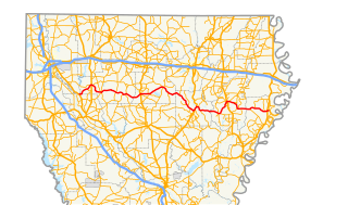
Louisiana Highway 4 (LA 4) is a state highway located in northern Louisiana. It runs 164.54 miles (264.80 km) in an east–west direction from U.S. Highway 71 (US 71) at Loggy Bayou to LA 605 in Newellton.
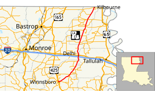
Louisiana Highway 17 (LA 17) is a state highway located in northeastern Louisiana. It runs 66.53 miles (107.07 km) in a north–south direction from the junction of U.S. Highway 425 (US 425), LA 4, LA 15, and LA 130 in Winnsboro to the Arkansas state line at Kilbourne.

Louisiana Highway 29 (LA 29) is a state highway located in southern Louisiana. It runs 54.09 miles (87.05 km) in a north–south direction from LA 13 north of Eunice to LA 114 west of Moreauville.

Louisiana Highway 123 (LA 123) is a state highway located in Grant Parish, Louisiana. It runs 15.95 miles (25.67 km) in a southwest to northeast direction from LA 8 east of Colfax to US 165 east of Breezy Hill. The signage for LA 123 carries east–west directional banners unlike most odd numbered state highways in the primary range, which are bannered north–south.
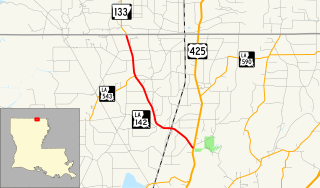
Louisiana Highway 142 (LA 142) is a state highway located in Morehouse Parish, Louisiana. It runs 8.75 miles (14.08 km) in a north–south direction from U.S. Highway 425 (US 425) north of Bastrop through Beekman to the Arkansas state line.

Louisiana Highway 139 (LA 139) is a state highway located in northeastern Louisiana. It runs 20.20 miles (32.51 km) in a north–south direction from U.S. Highway 80 (US 80) in Monroe to the junction of US 165, US 425, LA 2, and LA 593 in Bastrop.
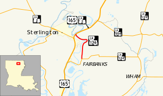
Louisiana Highway 136 (LA 136) is a state highway located in Ouachita Parish, Louisiana that runs 3.50 miles (5.63 km) in a north–south direction from LA 134 at Fairbanks to a junction with U.S. Highway 165 (US 165) and LA 2 at the eastern limit of Sterlington.
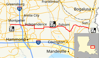
Louisiana Highway 40 (LA 40) is a state highway located in southeastern Louisiana. It runs 53.11 miles (85.47 km) in an east–west direction from LA 43 south of Montpelier to LA 41 in Bush.

Louisiana Highway 68 (LA 68) is a state highway located in southeastern Louisiana. It runs 19.13 miles (30.79 km) in a north–south direction from U.S. Highway 61 (US 61) north of Port Hudson to LA 19 in Wilson.
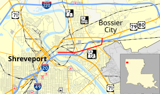
Louisiana Highway 72 (LA 72) is a state highway located in Bossier City, Louisiana. It runs 2.49 miles (4.01 km) in an east–west direction from the intersection of Barksdale Boulevard and Hamilton Road to a junction with the concurrent U.S. Highways 79 and 80.

Louisiana Highway 101 (LA 101) is a state highway located in southwestern Louisiana. It runs 17.28 miles (27.81 km) in a general north–south direction from LA 14 in Hayes to LA 383 north of Iowa.

Louisiana Highway 116 (LA 116) is a state highway located in Rapides Parish, Louisiana. It runs 8.39 miles (13.50 km) in an east–west direction from U.S. Highway 165 (US 165) in Pineville to LA 28 at a point east of Pineville.
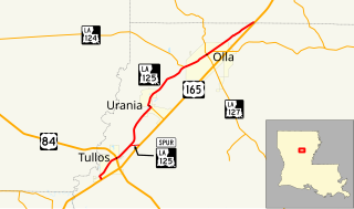
Louisiana Highway 125 (LA 125) is a state highway located in LaSalle Parish, Louisiana. It runs 12.51 miles (20.13 km) in a southwest to northeast direction from U.S. Highway 165 (US 165) in Tullos to a second junction with US 165 northeast of Olla.
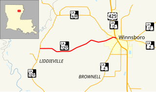
Louisiana Highway 130 (LA 130) is a state highway located in Franklin Parish, Louisiana. It runs 7.32 miles (11.78 km) in an east–west direction from LA 135 north of Liddieville to a junction with U.S. Highway 425 (US 425), LA 4, LA 15, and LA 17 in Winnsboro.
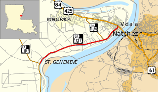
Louisiana Highway 131 (LA 131) is a state highway located in Concordia Parish, Louisiana. It runs 6.80 miles (10.94 km) in a southwest to northeast direction from LA 15 in St. Genevieve to U.S. Highway 84 (US 84) and U.S. Highway 425 (US 425) in Vidalia.
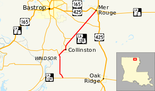
Louisiana Highway 138 (LA 138) is a state highway located in Morehouse Parish, Louisiana. It runs 12.74 miles (20.50 km) in a north–south direction from LA 134 south of Collinston to a junction with U.S. Highway 165 (US 165), U.S. Highway 425 (US 425), and LA 2 in Mer Rouge.


