Louisiana Highway 36

Last updated

Louisiana 36 (2008).svg

Louisiana Highway 36
LA 36 map.svg
Route information
Maintained by Louisiana DOTD
Length 19.0 mi [1] (30.6 km)
Existed 1955 renumbering – present
Major junctions
West endLouisiana 21 (2008).svg LA 21 in Covington
 Louisiana 59 (2008).svg LA 59 in Abita Springs
Louisiana 434 (2008).svg LA 434 in St. Tammany Corner
East endLouisiana 41 (2008).svg LA 41 in Hickory
Location
Parishes St. Tammany
Highway system
  • Louisiana Highway System
Louisiana 35 (2008).svg LA 35 LA 37 Louisiana 37 (2008).svg

Louisiana Highway 36 (LA 36) is a state highway in Louisiana that serves St. Tammany Parish. It spans 19.0 miles (30.6 km) and is bannered east/west.

A state highway, state road, or state route is usually a road that is either numbered or maintained by a sub-national state or province. A road numbered by a state or province falls below numbered national highways in the hierarchy. Roads maintained by a state or province include both nationally numbered highways and un-numbered state highways. Depending on the state, "state highway" may be used for one meaning and "state road" or "state route" for the other.

Louisiana State of the United States of America

Louisiana is a state in the Deep South region of the South Central United States. It is the 31st most extensive and the 25th most populous of the 50 United States. Louisiana is bordered by the state of Texas to the west, Arkansas to the north, Mississippi to the east, and the Gulf of Mexico to the south. A large part of its eastern boundary is demarcated by the Mississippi River. Louisiana is the only U.S. state with political subdivisions termed parishes, which are equivalent to counties. The state's capital is Baton Rouge, and its largest city is New Orleans.

Contents

Route description

From the west, LA 36 begins at an intersection with LA 21 in Covington and heads east. It enters a brief overlap with LA 59 in Abita Springs for approximately a quarter of a mile. It absorbs LA 435 and then heads east, terminating at LA 41 in Hickory.

Louisiana Highway 21 highway in Louisiana

Louisiana Highway 21 is a state highway in Louisiana that serves St. Tammany and Washington Parishes. It spans 51.76 miles (83.30 km) and is signed north and south.

Louisiana Highway 59 highway in Louisiana

Louisiana Highway 59 (LA 59) is a state highway located in St. Tammany Parish, Louisiana. It runs 11.74 miles (18.89 km) in a north–south direction from U.S. Highway 190 (US 190) in Mandeville to LA 21 north of Abita Springs.

Louisiana Highway 41 highway in Louisiana

Louisiana Highway 41 (LA 41) is a state highway located in St. Tammany Parish, Louisiana. It runs 23.07 miles (37.13 km) in a north–south direction from the junction of U.S. Highway 11 (US 11) and LA 3081 in Pearl River to LA 21 in Bush.

In 2008 the stop signs for the intersections in Abita Springs' center were eliminated as all the intersections were amalgamated into a roundabout, ensuring a smoother flow of traffic as left turns ceased to exist. LA 36 is an undivided two-lane highway for its entire length. [1]

Roundabout Traffic intersection

A roundabout is a type of circular intersection or junction in which road traffic is permitted to flow in one direction around a central island, and priority is typically given to traffic already in the junction.

History

The original 1955 route of LA 36 originally went as far west as Hammond, using what is now Business US 190 through Covington, then what is now US 190 between Business 190 and US 51 west to Hammond. It was truncated to LA 21 when US 190 was moved to its current routing between US 51 and Business 190, and when what is now Business 190 became US 190.

U.S. Route 190 Business (Covington, Louisiana) highway in Covington, Louisiana

U.S. Highway 190 Business is a state highway in Louisiana that serves St. Tammany Parish. It spans 2.94 miles (4.73 km) in a southeast to northwest direction. It is known locally as 21st Avenue and Boston Street. It is also the route used to access LA 21 South.

Major junctions

The entire route is in St. Tammany Parish.

Locationmi [1] kmDestinationsNotes
Covington 0.00.0Louisiana 21 (2008).svg LA 21 (Military Road)
Abita Springs 2.64.2Louisiana 59 (2008).svg LA 59 (Range Line Road)West end of LA 59 overlap
2.94.7Louisiana 435 (2008).svg LA 435 east (Main Street)Western terminus of LA 435
3.04.8Louisiana 59 (2008).svg LA 59 (Level Street) Roundabout, east end of LA 59 overlap
11.117.9Louisiana 1088 (2008).svgI-12.svg LA 1088 west to I-12 Eastern terminus of LA 1088
St. Tammany Corner 12.820.6Louisiana 434 (2008).svgI-12.svg LA 434 south to I-12 Northern terminus of LA 434
Hickory 19.030.6Louisiana 41 (2008).svg LA 41  Bogalusa, Pearl River
1.000 mi = 1.609 km; 1.000 km = 0.621 mi

Related Research Articles

Interstate 12 (I-12) is an Interstate Highway located entirely within the U.S. state of Louisiana. It spans a total of 86.65 miles (139.45 km) in an east–west direction from I-10 in Baton Rouge to an interchange with both I-10 and I-59 in Slidell. Along the way, it passes through the city of Hammond, where it intersects I-55 and US 51. It also serves the smaller cities of Denham Springs and Ponchatoula, as well as the St. Tammany Parish cities of Covington and Mandeville. Skirting the northern shore of Lake Pontchartrain, I-12 serves as a northern bypass of the New Orleans metropolitan area and as an alternate route for I-10, which serves the city of New Orleans itself.

Louisiana Highway 16 highway in Louisiana

Louisiana Highway 16 (LA 16) is a state highway located in southeastern Louisiana. It runs 110.27 miles (177.46 km) in a general east–west direction from LA 22 south of French Settlement to LA 21 in Sun.

Louisiana Highway 22 highway in Louisiana

Louisiana Highway 22 (LA 22) is a state highway located in southeastern Louisiana. It runs 71.15 miles (114.50 km) in a general east–west direction from the junction of LA 75 and LA 942 in Darrow to U.S. Highway 190 (US 190) in Mandeville.

Louisiana Highway 25 highway in Louisiana

Louisiana Highway 25 (LA 25) is a state highway located in southeastern Louisiana. It runs 38.72 miles (62.31 km) in a north–south direction from U.S. Highway 190 (US 190) in Covington to the Mississippi state line north of Warnerton.

Louisiana Highway 433 highway in Louisiana

Louisiana Highway 433 is a state highway in Louisiana that serves St. Tammany Parish. It spans 14.8 miles (23.8 km) in a west to east direction. It is known at various points as Thompson Road, Bayou Liberty Road, Pontchartrain Drive, Old Spanish Trail, and Rigolets Road.

Louisiana Highway 1077 highway in Louisiana

Louisiana Highway 1077 (LA 1077) is a state highway located in southeastern Louisiana. It runs 20.61 miles (33.17 km) in a general north–south direction from a dead end at Lake Pontchartrain in Madisonville to a junction with LA 25 south of Folsom.

Louisiana Highway 1065 highway in Louisiana

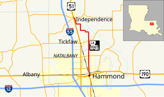
Louisiana Highway 1065 is a mostly rural highway in Tangipahoa Parish, Louisiana between Hammond and Independence. In its more trafficked southern end it is known as North Cherry Street and outside Hammond, North Cherry Street Extension. LA 1065 is a two-lane highway for the entirety of its 11.1-mile-length (17.9 km).

Louisiana Highway 40 highway in Louisiana

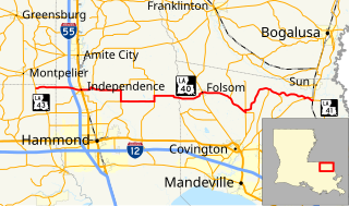
Louisiana Highway 40 (LA 40) is a state highway located in southeastern Louisiana. It runs 53.11 miles (85.47 km) in an east–west direction from LA 43 south of Montpelier to LA 41 in Bush.

U.S. Route 61/190 Business highway in Louisiana

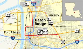
U.S. Highway 61/190 Business is a state highway in Louisiana that serves East Baton Rouge Parish. It spans 10.89 miles (17.53 km) in a southeast to northwest direction and it is bannered as Business 61/190, with no directional shields. It generally follows the 1940s-1950s alignment of US 61/190 through Baton Rouge.

Louisiana Highway 3114 was a state highway in Louisiana that served St. Tammany Parish. It spanned a total of 1.7 miles (2.7 km) along the present route of U.S. 190 on the north side of Covington.

References

  1. 1 2 3 Google (January 1, 2015). "Louisiana Highway 36" (Map). Google Maps . Google. Retrieved January 1, 2015.
KML file (edithelp)
KML is from Wikidata