Louisiana Highway 21

Last updated

Louisiana 21 (2008).svg

Louisiana Highway 21
LA 21 map.svg
Route information
Maintained by Louisiana DOTD
Length 51.76 mi (83.30 km)
Existed 1955 renumbering – present
Major junctions
South endLouisiana 22 (2008).svgLouisiana 1077 (2008).svg LA 22 / LA 1077 in Madisonville
 I-12.svg I-12 in Covington
US 190.svg US 190 in Covington
Louisiana 36 (2008).svg LA 36 in Covington
Louisiana 59 (2008).svg LA 59 south of Waldheim
Louisiana 40 (2008).svg LA 40 south of Bush
Louisiana 41 (2008).svg LA 41 in Bush
Louisiana 16 (2008).svg LA 16 in Sun
Louisiana 10 (2008).svg LA 10 in Bogalusa
North endElongated circle 35.svg MS 35 at state line
Highway system
  • Louisiana Highway System
Louisiana 20 (2008).svg LA 20 LA 22 Louisiana 22 (2008).svg

Louisiana Highway 21 (LA 21) is a state highway in Louisiana that serves St. Tammany and Washington Parishes. It spans 51.76 miles (83.30 km) and is bannered north/south.

A state highway, state road, or state route is usually a road that is either numbered or maintained by a sub-national state or province. A road numbered by a state or province falls below numbered national highways in the hierarchy. Roads maintained by a state or province include both nationally numbered highways and un-numbered state highways. Depending on the state, "state highway" may be used for one meaning and "state road" or "state route" for the other.

Louisiana State of the United States of America

Louisiana is a state in the Deep South region of the South Central United States. It is the 31st most extensive and the 25th most populous of the 50 United States. Louisiana is bordered by the state of Texas to the west, Arkansas to the north, Mississippi to the east, and the Gulf of Mexico to the south. A large part of its eastern boundary is demarcated by the Mississippi River. Louisiana is the only U.S. state with political subdivisions termed parishes, which are equivalent to counties. The state's capital is Baton Rouge, and its largest city is New Orleans.

Contents

Route description

From the south, LA 21 begins at an intersection with Louisiana Highway 22 and Louisiana Highway 1077 in Madisonville, where LA 21 assumes the trajectory of LA 1077 and heads northeast. LA 1077 branches to the northwest before LA 21 intersects Interstate 12. [1] From south of I-12 and until joining US 190 Business on 21st Avenue in Covington, LA 21 is multilane, in places divided by a median or by a center turn lane, with some control of access. [2]

Louisiana Highway 22 highway in Louisiana

Louisiana Highway 22 (LA 22) is a state highway located in southeastern Louisiana. It runs 71.15 miles (114.50 km) in a general east–west direction from the junction of LA 75 and LA 942 in Darrow to U.S. Highway 190 (US 190) in Mandeville.

Louisiana Highway 1077 highway in Louisiana

Louisiana Highway 1077 (LA 1077) is a state highway located in southeastern Louisiana. It runs 20.61 miles (33.17 km) in a general north–south direction from a dead end at Lake Pontchartrain in Madisonville to a junction with LA 25 south of Folsom.

Interstate 12 (I-12) is an Interstate Highway located entirely within the U.S. state of Louisiana. It spans a total of 86.65 miles (139.45 km) in an east–west direction from I-10 in Baton Rouge to an interchange with both I-10 and I-59 in Slidell. Along the way, it passes through the city of Hammond, where it intersects I-55 and US 51. It also serves the smaller cities of Denham Springs and Ponchatoula, as well as the St. Tammany Parish cities of Covington and Mandeville. Skirting the northern shore of Lake Pontchartrain, I-12 serves as a northern bypass of the New Orleans metropolitan area and as an alternate route for I-10, which serves the city of New Orleans itself.

Improved, multilane, divided section of LA 21 between Covington and Madisonville. See also list of numbered highways in Louisiana. LA 21 Covington south.JPG
Improved, multilane, divided section of LA 21 between Covington and Madisonville. See also list of numbered highways in Louisiana.

Through most of Covington LA 21 is in a mostly two-lane undivided concurrency with US 190 Business, which returns to U.S. Route 190 on the east side of Covington—an area known as Claiborne Hill. After intersecting US 190 and before leaving Covington cosigned as Military Road, LA 21 absorbs LA 36 and continues northeastward, absorbing LA 59 and entering a brief concurrency with Louisiana Highway 40 in Bush for less than one mile (1.6 km). Between Bush and Sun, LA 21 widens to a four lane, divided highway after merging Louisiana Highway 41, continuing due north from the merge. In Sun LA 21 absorbs LA 16 and continues northward to Bogalusa, where LA 21 intersects LA 10. LA 21 then runs north through Varnado and Angie before becoming Mississippi Highway 35 at the state line.

Business route short special route connected to a parent numbered highway at its beginning, then routed through the central business district of a nearby city or town, and finally reconnecting with the same parent numbered highway again at its end

A business route in the United States is a short special route connected to a parent numbered highway at its beginning, then routed through the central business district of a nearby city or town, and finally reconnecting with the same parent numbered highway again at its end.

U.S. Route 190 highway in the United States

U.S. Route 190 (US 190) is an east–west United States Highway in Louisiana and Texas. Segments of US 190 will be upgraded to Interstate 14 (I-14), the first 24.8-mile (39.9 km) segment was opened on January 26, 2017.

Concurrency (road) instance of one physical road bearing two or more different highways

A concurrency in a road network is an instance of one physical roadway bearing two or more different route numbers. When two roadways share the same right-of-way, it is sometimes called a common section or commons. Other terminology for a concurrency includes overlap, coincidence, duplex, triplex, multiplex, dual routing or triple routing.

Major intersections

ParishLocationmikmDestinationsNotes
St. Tammany Madisonville Louisiana 22 (2008).svgLouisiana 1077 (2008).svg LA 22 (Mulberry Street) / LA 1077 south (Main Street) Fairview Riverside State Park, Maritime Museum south end of LA 1077 overlap
Louisiana 1077 (2008).svgI-12.svg LA 1077 north to I-12 north end of LA 1077 overlap
I-12.svg I-12  Hammond, Slidell I-12 exit 59
Covington No image.svgBusiness plate.svgNo image.svg
US 190.svg US 190 Bus. west (West 21st Avenue)
south end of US 190 Bus. overlap
US 190.svgI-12.svg US 190 west to I-12  Mandeville, New Orleans interchange
No image.svgBusiness plate.svgNo image.svgNo image wide.svg
US 190.svgUS 190.svg US 190 Bus. east to US 190  Franklinton
north end of US 190 Bus. overlap
Louisiana 36 (2008).svg LA 36 east Abita Springs
Louisiana 1082 (2008).svg LA 1082 north
Louisiana 59 (2008).svg LA 59 south Abita Springs
Louisiana 1084 (2008).svg LA 1084 east
Waldheim Louisiana 1083 (2008).svg LA 1083 southsouth end of LA 1083 overlap
Louisiana 1083 (2008).svg LA 1083 northnorth end of LA 1083 overlap
Louisiana 40 (2008).svg LA 40 westsouth end of LA 40 overlap
Louisiana 40 (2008).svg LA 40 eastnorth end of LA 40 overlap
Louisiana 41 (2008).svg LA 41 south
Sun Louisiana 16 (2008).svg LA 16 west
Washington Louisiana 1075 (2008).svg LA 1075 north
Louisiana 3124 (2008).svg LA 3124 north Bogalusa Central Business District
Bogalusa Louisiana 10 (2008).svg LA 10
Louisiana 436 (2008).svg LA 436 east
Louisiana 436 (2008).svg LA 436  Pine, Franklinton
Varnado Louisiana 436-1 (2008).svg LA 436-1 east
Angie Louisiana 1071 (2008).svg LA 1071 east
Louisiana 438 (2008).svg LA 438 westsouth end of LA 438 overlap
Louisiana 438 (2008).svg LA 438 eastnorth end of LA 438 overlap
Elongated circle 35.svg MS 35 north Columbia Mississippi state line
1.000 mi = 1.609 km; 1.000 km = 0.621 mi

Related Research Articles

U.S. Route 425 highway in the United States

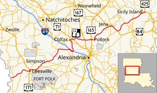
U.S. Route 425 is a north–south United States highway, first commissioned in 1989. Its route number is a "violation" of the usual AASHTO numbering scheme, as it comes nowhere near its implied "parent", US 25.

U.S. Route 165 highway in the United States

U.S. Route 165 is a north–south United States highway spur of U.S. Highway 65. It currently runs for 412 miles (663 km) from U.S. Route 90 in Iowa, Louisiana north to U.S. Highway 70 in North Little Rock, Arkansas. The route passes through the states of Arkansas and Louisiana. It passes through the cities of Monroe and Alexandria in Louisiana. A segment of US 165 serves as a routing of the Great River Road within Arkansas.

Louisiana Highway 8 highway in Louisiana

Louisiana Highway 8 is a state highway in Louisiana. It spans 156 miles (251 km) beginning at the Louisiana/Texas state line west of Leesville and ending at an intersection with U.S. Route 425 and LA 15 in Sicily Island.

Louisiana Highway 28 highway in Louisiana

Louisiana Highway 28 (LA 28) is a state highway located in central Louisiana. It runs 86.97 miles (139.96 km) in an east–west direction from the junction of U.S. Highway 171 (US 171) and LA 8 in Leesville to US 84 west of Jonesville.

Louisiana Highway 6 highway in Louisiana

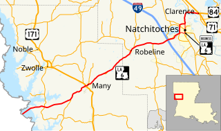
Louisiana Highway 6 (LA 6) is a state highway located in western central Louisiana. It runs 54.52 miles (87.74 km) in an east–west direction from the Texas state line southwest of Many to U.S. Highway 71 (US 71) and U.S. Highway 84 (US 84) in Clarence.

Louisiana Highway 12 highway in Louisiana

Louisiana Highway 12 (LA 12) is a state highway located in southwestern Louisiana. It runs 34.64 miles (55.75 km) in an east–west direction from the Texas state line west of Starks to a junction with U.S. Highway 171 (US 171) and U.S. Highway 190 (US 190) in Ragley.

Louisiana Highway 16 highway in Louisiana

Louisiana Highway 16 (LA 16) is a state highway located in southeastern Louisiana. It runs 110.27 miles (177.46 km) in a general east–west direction from LA 22 south of French Settlement to LA 21 in Sun.

Louisiana Highway 25 highway in Louisiana

Louisiana Highway 25 (LA 25) is a state highway located in southeastern Louisiana. It runs 38.72 miles (62.31 km) in a north–south direction from U.S. Highway 190 (US 190) in Covington to the Mississippi state line north of Warnerton.

Louisiana Highway 433 highway in Louisiana

Louisiana Highway 433 is a state highway in Louisiana that serves St. Tammany Parish. It spans 14.8 miles (23.8 km) in a west to east direction. It is known at various points as Thompson Road, Bayou Liberty Road, Pontchartrain Drive, Old Spanish Trail, and Rigolets Road.

Louisiana Highway 59 highway in Louisiana

Louisiana Highway 59 (LA 59) is a state highway located in St. Tammany Parish, Louisiana. It runs 11.74 miles (18.89 km) in a north–south direction from U.S. Highway 190 (US 190) in Mandeville to LA 21 north of Abita Springs.

Louisiana Highway 415 highway in Louisiana

Louisiana Highway 415 is a state highway in Louisiana. It spans north–south through West Baton Rouge Parish and Pointe Coupee Parish for 25.3 miles (40.7 km).

Louisiana Highway 112 highway in Louisiana

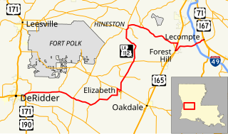
Louisiana Highway 112 is a state highway in Louisiana. It spans 80.9 miles (130.2 km) and runs from west to east. LA 112 is a mostly rural two lane highway with a maximum speed limit of 55 miles per hour (89 km/h) per hour. The western terminus is at an intersection with U.S. Route 171/U.S. Route 190 in Beauregard Parish and the eastern terminus at an intersection with US 167/US 71 in Rapides Parish. Although the highway runs west to east it meanders through three parishes and on the map appears to make a large S.

U.S. Route 190 Business (Covington, Louisiana) highway in Covington, Louisiana

U.S. Highway 190 Business is a state highway in Louisiana that serves St. Tammany Parish. It spans 2.94 miles (4.73 km) in a southeast to northwest direction. It is known locally as 21st Avenue and Boston Street. It is also the route used to access LA 21 South.

Louisiana Highway 103 highway in Louisiana

Louisiana Highway 103 is a state highway located in St. Landry Parish that spans 39.5 miles (63.6 km) in a wide semi-circle around the north side of Opelousas. The route is not bannered but runs in an overall west–east direction from U.S. Highway 190 near Lawtell to LA 31 in Leonville. Along the way, it passes through the towns of Washington and Port Barre.

References

  1. LA 1077 has a separate interchange with I-12.
  2. As of 2010 much of the stretch between I-12 and 21st Avenue remained under reconstruction amid traffic jams.
KML file (edithelp)
KML is from Wikidata