
A lithosphere is the rigid, outermost rocky shell of a terrestrial planet or natural satellite. On Earth, it is composed of the crust and the lithospheric mantle, the topmost portion of the upper mantle that behaves elastically on time scales of up to thousands of years or more. The crust and upper mantle are distinguished on the basis of chemistry and mineralogy.

The asthenosphere is the mechanically weak and ductile region of the upper mantle of Earth. It lies below the lithosphere, at a depth between c. 80 and 200 km below the surface, and extends as deep as 700 km (430 mi). However, the lower boundary of the asthenosphere is not well defined.
Subduction is a geological process in which the oceanic lithosphere and some continental lithosphere is recycled into the Earth's mantle at the convergent boundaries between tectonic plates. Where one tectonic plate converges with a second plate, the heavier plate dives beneath the other and sinks into the mantle. A region where this process occurs is known as a subduction zone, and its surface expression is known as an arc-trench complex. The process of subduction has created most of the Earth's continental crust. Rates of subduction are typically measured in centimeters per year, with rates of convergence as high as 11 cm/year.

A convergent boundary is an area on Earth where two or more lithospheric plates collide. One plate eventually slides beneath the other, a process known as subduction. The subduction zone can be defined by a plane where many earthquakes occur, called the Wadati–Benioff zone. These collisions happen on scales of millions to tens of millions of years and can lead to volcanism, earthquakes, orogenesis, destruction of lithosphere, and deformation. Convergent boundaries occur between oceanic-oceanic lithosphere, oceanic-continental lithosphere, and continental-continental lithosphere. The geologic features related to convergent boundaries vary depending on crust types.

Tectonics are the processes that result in the structure and properties of the Earth's crust and its evolution through time. The field of planetary tectonics extends the concept to other planets and moons.

A mantle plume is a proposed mechanism of convection within the Earth's mantle, hypothesized to explain anomalous volcanism. Because the plume head partially melts on reaching shallow depths, a plume is often invoked as the cause of volcanic hotspots, such as Hawaii or Iceland, and large igneous provinces such as the Deccan and Siberian Traps. Some such volcanic regions lie far from tectonic plate boundaries, while others represent unusually large-volume volcanism near plate boundaries.

Island arcs are long chains of active volcanoes with intense seismic activity found along convergent tectonic plate boundaries. Most island arcs originate on oceanic crust and have resulted from the descent of the lithosphere into the mantle along the subduction zone. They are the principal way by which continental growth is achieved.

Oceanic crust is the uppermost layer of the oceanic portion of the tectonic plates. It is composed of the upper oceanic crust, with pillow lavas and a dike complex, and the lower oceanic crust, composed of troctolite, gabbro and ultramafic cumulates. The crust overlies the rigid uppermost layer of the mantle. The crust and the rigid upper mantle layer together constitute oceanic lithosphere.
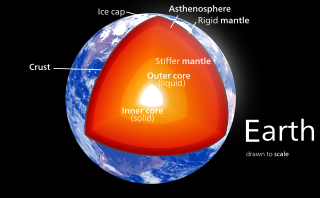
Earth's mantle is a layer of silicate rock between the crust and the outer core. It has a mass of 4.01×1024 kg (8.84×1024 lb) and makes up 67% of the mass of Earth. It has a thickness of 2,900 kilometers (1,800 mi) making up about 46% of Earth's radius and 84% of Earth's volume. It is predominantly solid but, on geologic time scales, it behaves as a viscous fluid, sometimes described as having the consistency of caramel. Partial melting of the mantle at mid-ocean ridges produces oceanic crust, and partial melting of the mantle at subduction zones produces continental crust.

The core–mantle boundary (CMB) of Earth lies between the planet's silicate mantle and its liquid iron–nickel outer core, at a depth of 2,891 km (1,796 mi) below Earth's surface. The boundary is observed via the discontinuity in seismic wave velocities at that depth due to the differences between the acoustic impedances of the solid mantle and the molten outer core. P-wave velocities are much slower in the outer core than in the deep mantle while S-waves do not exist at all in the liquid portion of the core. Recent evidence suggests a distinct boundary layer directly above the CMB possibly made of a novel phase of the basic perovskite mineralogy of the deep mantle named post-perovskite. Seismic tomography studies have shown significant irregularities within the boundary zone and appear to be dominated by the African and Pacific Large low-shear-velocity provinces (LLSVP).

Earth's crust is its thick outer shell of rock, referring to less than one percent of the planet's radius and volume. It is the top component of the lithosphere, a solidified division of Earth's layers that includes the crust and the upper part of the mantle. The lithosphere is broken into tectonic plates whose motion allows heat to escape the interior of Earth into space.

The Lehmann discontinuity is an abrupt increase of P-wave and S-wave velocities at the depth of 220 km (140 mi) in Earth's mantle, discovered by seismologist Inge Lehmann. The thickness is 220 km. It appears beneath continents, but not usually beneath oceans, and does not readily appear in globally averaged studies. Several explanations have been proposed: a lower limit to the pliable asthenosphere, a phase transition, and most plausibly, depth variation in the shear wave anisotropy.

Mantle convection is the very slow creep of Earth's solid silicate mantle as convection currents carry heat from the interior to the planet's surface. Mantle convection causes tectonic plates to move around the Earth's surface.

The Marquesas hotspot is a volcanic hotspot in the southern Pacific Ocean. It is responsible for the creation of the Marquesas Islands – a group of eight main islands and several smaller ones – and a few seamounts. The islands and seamounts formed between 5.5 and 0.4 million years ago and constitute the northernmost volcanic chain in French Polynesia.
Non-volcanic passive margins (NVPM) constitute one end member of the transitional crustal types that lie beneath passive continental margins; the other end member being volcanic passive margins (VPM). Transitional crust welds continental crust to oceanic crust along the lines of continental break-up. Both VPM and NVPM form during rifting, when a continent rifts to form a new ocean basin. NVPM are different from VPM because of a lack of volcanism. Instead of intrusive magmatic structures, the transitional crust is composed of stretched continental crust and exhumed upper mantle. NVPM are typically submerged and buried beneath thick sediments, so they must be studied using geophysical techniques or drilling. NVPM have diagnostic seismic, gravity, and magnetic characteristics that can be used to distinguish them from VPM and for demarcating the transition between continental and oceanic crust.
The Society hotspot is a volcanic hotspot in the south Pacific Ocean which is responsible for the formation of the Society Islands, an archipelago of fourteen volcanic islands and atolls spanning around 720 kilometres (450 mi) of the ocean which formed between 4.5 and <1 Ma.

Large low-shear-velocity provinces (LLSVPs), also called large low-velocity provinces (LLVPs) or superplumes, are characteristic structures of parts of the lowermost mantle, the region surrounding the outer core deep inside the Earth. These provinces are characterized by slow shear wave velocities and were discovered by seismic tomography of deep Earth. There are two main provinces: the African LLSVP and the Pacific LLSVP, both extending laterally for thousands of kilometers and possibly up to 1,000 kilometres vertically from the core–mantle boundary. These have been named Tuzo and Jason respectively, after Tuzo Wilson and W. Jason Morgan, two geologists acclaimed in the field of plate tectonics. The Pacific LLSVP is 3,000 kilometers across and underlies four hotspots on Earth's crust that suggest multiple mantle plumes underneath. These zones represent around 8% of the volume of the mantle, or 6% of the entire Earth.

The lithosphere–asthenosphere boundary represents a mechanical difference between layers in Earth's inner structure. Earth's inner structure can be described both chemically and mechanically. The lithosphere–asthenosphere boundary lies between Earth's cooler, rigid lithosphere and the warmer, ductile asthenosphere. The actual depth of the boundary is still a topic of debate and study, although it is known to vary according to the environment.
The upper mantle of Earth is a very thick layer of rock inside the planet, which begins just beneath the crust and ends at the top of the lower mantle at 670 km (420 mi). Temperatures range from approximately 500 K at the upper boundary with the crust to approximately 1,200 K at the boundary with the lower mantle. Upper mantle material that has come up onto the surface comprises about 55% olivine, 35% pyroxene, and 5 to 10% of calcium oxide and aluminum oxide minerals such as plagioclase, spinel, or garnet, depending upon depth.
Intraplate volcanism is volcanism that takes place away from the margins of tectonic plates. Most volcanic activity takes place on plate margins, and there is broad consensus among geologists that this activity is explained well by the theory of plate tectonics. However, the origins of volcanic activity within plates remains controversial.
![Velocity of seismic waves in the Earth versus depth. S-waves (seismic shear waves) cannot propagate in liquids, leading to negligible velocity in the liquid outer core. The seismic velocities very near the surface ([?] 220+-30 km) are markedly lower than at greater depths, demarking the LVZ. Speeds of seismic waves.svg](http://upload.wikimedia.org/wikipedia/commons/thumb/6/60/Speeds_of_seismic_waves.svg/300px-Speeds_of_seismic_waves.svg.png)
