Lower Lonsdale

Last updated
The Shipyards with Polygon Gallery at left Shipyards as seen from Lonsdale Quay - May 2018.jpg
The Shipyards with Polygon Gallery at left

Lower Lonsdale is a historic waterfront neighbourhood in the city of North Vancouver. [1] Lower Lonsdale runs up Lonsdale Avenue from Lonsdale Quay to Keith Road. 
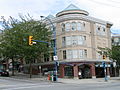
The area is characterized by its progressive feel of trendy businesses, [2] a high end sex shop, outdoor fitness stores, eclectic cafes, and diverse restaurants. [3] With a history of shipbuilding, in 2021 Lower Lonsdale underwent a major waterfront renewal processes. [4] The old shipyards have been torn down, making way for new public spaces, buildings, condominiums, and fashionable outlets.

Contents

History

Before the emergence of today’s neighbourhood, the First People to call this parcel of land home was the Squamish peoples who built permanent villages and fishing camps along the community’s shoreline and river-inlets, sustaining themselves by fishing, hunting and food-gathering. Just over 200 years ago, the Squamish peoples had their first encounter with the Spanish who were the first Europeans to arrive in the area. However, in 1792, Captain George Vancouver of England also arrived to explore the shores of North Vancouver. [5] But, it was not until 1860 that a Catholic Missionary was ordered to build a church on the water front of what is now called St. Pauls Church. Shortly afterwards, T. W. Graham and George Scrimgeour secured a pre-emption of 150 acres (0.61 km2), the first on the North Shore of the Burrard Inlet. They proceeded to build a mill and named it The Pioneer Mills. This consequently initiated an influx of residents. However, with the mill facing bankruptcy, an American by the name of Sewell Prescott Moody bought it. The name Lonsdale comes from Arthur Pemberton Heywood-Lonsdale who, along with J.P. Fell opened land to settlers in 1903. [6] :156

Transportation

Lower Lonsdale is served on public transit by the Lonsdale Quay SeaBus terminal and bus exchange.

Gentrification

In the 1990s and 2000s, the City of North Vancouver embarked on an ambitious plan to redevelop former industrial lands of Lower Lonsdale. Highrise and lowrise condominium and other multi-family developments were constructed in the area between 3rd Street and south to the waterfront.

During that time, many new restaurants and retailers have located in the stretch of Lonsdale Avenue between 3rd Street and Burrard Inlet. The City also oversaw the construction of the John Braithwaite Community Center, located in the 100 block of 1st Street.

Related Research Articles

<span class="mw-page-title-main">SeaBus</span> Passenger-only ferry service in Metro Vancouver, Canada

The SeaBus is a passenger-only ferry service in Metro Vancouver, British Columbia, Canada. It crosses Burrard Inlet to connect the cities of Vancouver and North Vancouver. Owned by TransLink and operated by the Coast Mountain Bus Company, the SeaBus forms an important part of the region's integrated public transportation system. In 2022, the SeaBus had a ridership of 4,245,700, or about 12,400 per weekday as of the fourth quarter of 2022.

<span class="mw-page-title-main">North Vancouver (city)</span> City in British Columbia, Canada

The City of North Vancouver is a city on the north shore of Burrard Inlet, British Columbia, Canada. It is the smallest in area and the most urbanized of the North Shore municipalities. Although it has significant industry of its own – including shipping, chemical production, and film production – the city is considered to be a suburb of Vancouver. The city is served by the Royal Canadian Mounted Police, British Columbia Ambulance Service, and the North Vancouver City Fire Department.

<span class="mw-page-title-main">Kitsilano</span> Neighbourhood of Vancouver in British Columbia, Canada

Kitsilano is a neighbourhood located in the city of Vancouver, British Columbia, Canada. Kitsilano is named after Squamish chief August Jack Khatsahlano, and the neighbourhood is located in Vancouver's West Side along the south shore of English Bay, between the neighbourhoods of West Point Grey and Fairview. The area is mostly residential with two main commercial areas, West 4th Avenue and West Broadway, known for their retail stores, restaurants and organic food markets.

<span class="mw-page-title-main">Burrard Inlet</span> Coastal fjord in southwestern British Columbia, Canada

Burrard Inlet is a relatively shallow-sided fjord in northwestern Lower Mainland, British Columbia, Canada. Formed during the last Ice Age, it separates the City of Vancouver and the rest of the lowland Burrard Peninsula to the south from the coastal slopes of the North Shore Mountains, which span West Vancouver and the City and District of North Vancouver to the north.

<span class="mw-page-title-main">Burrard Peninsula</span> Peninsula in southwest British Columbia, Canada

The Burrard Peninsula is a peninsula in the Lower Mainland region of British Columbia, Canada, bounded by the Burrard Inlet to the north, the Georgia Strait to the west, the North Arm of Fraser River to the south, and the Pitt River and Douglas Island to the east. The City of Vancouver occupies almost all of the western half of the peninsula, and the Cities of Burnaby and New Westminster occupy more than half of the eastern half. At its northeastern end, the peninsula is connected to the Eagle Mountain and Mount Burke of the Coast Mountains via a small isthmus at the center of the Tri-Cities.

<span class="mw-page-title-main">False Creek</span> Inlet in Vancouver, British Columbia, Canada

False Creek is a short narrow inlet in the heart of Vancouver, separating the Downtown and West End neighbourhoods from the rest of the city. It is one of the four main bodies of water bordering Vancouver, along with English Bay, Burrard Inlet, and the Fraser River. Granville Island is located within the inlet.

The North Shore is a term commonly used to refer to several areas adjacent to Vancouver, British Columbia, Canada:

<span class="mw-page-title-main">North Vancouver (district municipality)</span> Municipality in British Columbia, Canada

The District of North Vancouver is a district municipality in British Columbia, Canada, and is part of Metro Vancouver. It surrounds the City of North Vancouver on three sides. As of 2016, the District stands as the second wealthiest city in Canada, with neighbouring West Vancouver the richest. The municipality is largely characterized as being a relatively quiet, affluent suburban hub home to many middle and upper-middle-class families. Homes in the District generally range from mid-sized family bungalows to very large luxury houses. A number of dense multi-family and mixed-use developments have popped up across the district in recent years; however, the District remains a primarily suburban municipality. The District is served by the Royal Canadian Mounted Police, British Columbia Ambulance Service, and the District of North Vancouver Fire Department.

<span class="mw-page-title-main">Capilano River</span> River in British Columbia, Canada

The Capilano River flows from north to south through the Coast Mountains on Vancouver's North Shore between West Vancouver and North Vancouver and empties into Burrard Inlet, opposite Stanley Park. The river is one of three primary sources of drinking water for residents of Greater Vancouver, and flows through the Capilano watershed. The Cleveland Dam, built in 1954, impounds a reservoir for this purpose. The entire area of the reservoir and watershed area upstream of the dam is closed to the public to ensure the quality of the drinking water. Prior to construction of the Cleveland Dam, the Capilano River deposited large amounts of sediment into Burrard Inlet. A dredge was needed to remove this sediment build-up in order to keep Burrard Inlet open for ship traffic.

<span class="mw-page-title-main">Coal Harbour</span> Neighbourhood in Vancouver, British Columbia, Canada

Coal Harbour is the name for a section of Burrard Inlet lying between Vancouver's Downtown Peninsula and the Brockton Point of Stanley Park. It has also now become the name of the neighbourhood adjacent to its southern shoreline.

This page is a listing of federal and provincial electoral districts located in the City of Vancouver, British Columbia, and for ridings which include the name Vancouver in their title, including those on Vancouver Island among which was the original first-use of the riding-name Vancouver. For ridings in any of the suburbs other than North Vancouver and West Vancouver, please see New Westminster (all other Lower Mainland ridings are descendants of the original New Westminster riding. Vancouver Island ridings not including the name "Vancouver" can be found at Vancouver Island.

<span class="mw-page-title-main">Downtown Vancouver</span> Neighbourhood of Vancouver in British Columbia, Canada

Downtown Vancouver is the central business district and the city centre neighbourhood of Vancouver, Canada, on the northwestern shore of the Burrard Peninsula in the Lower Mainland region of British Columbia. It occupies most of the north shore of the False Creek inlet, which cuts into the Burrard Peninsula creating the Downtown Peninsula, where the West End neighbourhood and Stanley Park are also located.

<span class="mw-page-title-main">History of Vancouver</span>

The history of Vancouver, British Columbia, is one that extends back thousands of years, with its first inhabitants arriving in the area following the Last Glacial Period. With its location on the western coast of Canada near the mouth of the Fraser River and on the waterways of the Strait of Georgia, Howe Sound, Burrard Inlet, and their tributaries, Vancouver has – for thousands of years – been a place of meeting, trade, and settlement.

Point Grey is a headland marking the southern entrance to English Bay and Burrard Inlet. The headland is the site of Wreck Beach, Tower Beach, Point Grey Beach and most notably, since 1925, on its top is the Point Grey Campus of the University of British Columbia.

<span class="mw-page-title-main">Great Vancouver Fire</span> 1886 fire that burned down most of Vancouver, British Columbia, Canada

The Great Vancouver Fire destroyed most of the newly incorporated city of Vancouver, British Columbia, Canada, on June 13, 1886. It started as two land clearing fires to the west of the city. The first fire was further away from the city and was clearing land for the roundhouse of the terminus of the Canadian Pacific Railway. The second fire was clearing land to extend the city to the west. The Great Fire occurred shortly after the township of Granville was incorporated into the City of Vancouver.

Upper Lonsdale is a suburban area in both the City and District of North Vancouver. This area runs north of Highway 1 to the corner of Lonsdale and Rockland. The first 5 blocks up Lonsdale Avenue are part of the City of North Vancouver, while the remaining blocks belong to the District of North Vancouver. Upper Lonsdale is the more residential part of Lonsdale Avenue, although it does have a couple of blocks of shops and services. The peak of Lonsdale Avenue sits at an elevation of 850 feet above sea level whereas Lower Lonsdale sits at sea level at some points). The bus line 230 to Upper Lonsdale and Lonsdale Quay serves the area all the way up to the end of Lonsdale Avenue, before going down Rockland Street. See Arthur Heywood-Lonsdale for the origins of the name Lonsdale.

<span class="mw-page-title-main">New Brighton Park</span> Park in British Columbia, Canada

Located in the Hastings-Sunrise district of Vancouver, British Columbia, Canada, New Brighton Park is a waterfront park facing the North Shore Mountains with beach access to the Burrard Inlet. The park is surrounded by industrial plants, the Hastings Racecourse, as well as access to the Port of Vancouver. During the summer, the park becomes a popular location for recreational activity. There is a soccer pitch, tennis courts, barbecue/picnic sites, two playgrounds, beaches, and an outdoor pool. For local residents, New Brighton Park provides a nearby location with similar facilities found at other popular recreational parks such as Kitsilano Beach, which is located on the west side of Vancouver. New Brighton Park is also in the process of being connected to Hastings Park via Creekway Park, which will allow people to walk and cycle between the two locations.

<span class="mw-page-title-main">History of Squamish and Tsleil-Waututh longshoremen, 1863–1963</span>

In the late 1870s, Squamish and Tsleil-Waututh communities on the North Shore of Burrard Inlet experienced an increase of physical and economic encroachment from the expansion of neighbouring Vancouver. Faced with urbanization and industrialization around reserve lands, Squamish and Tsleil-Waututh traditional economies became increasingly marginalized, while government-imposed laws increasingly restricted Native fishing, hunting, and access to land and waters for subsistence. In response, these communities increasingly turned to participating in the wage-labor economy.

<span class="mw-page-title-main">Lonsdale Quay</span> Ferry terminal and transit exchange in Metro Vancouver, Canada

Lonsdale Quay is a SeaBus ferry terminal and major transit exchange that serves Metro Vancouver's North Shore municipalities. The quay is located in the City of North Vancouver. The BCIT Marine Campus and Lonsdale Quay Market are located within the vicinity of the quay.

Marine Drive is the name for three major roadways in Greater Vancouver, British Columbia, Canada. The roads are known for running parallel to major bodies of water, with some sections being a major arterial road, while other serve local traffic. Marine Way is the name applied to a section of Marine Drive that was bypassed in the early 1980s.

References

  1. "Lower Lonsdale". www.tourismvancouver.com. Retrieved 2021-07-28.
  2. "Concept Shop".
  3. "Where to Eat".
  4. "City of North Van embarks on ambitious park plans". North Shore News. Retrieved 2021-07-28.
  5. "Captain George Vancouver | Monument Australia". monumentaustralia.org.au. Retrieved 2021-07-28.
  6. Akrigg, G.P.V.; Akrigg, Helen B. (1986), British Columbia Place Names (3rd, 1997 ed.), Vancouver: UBC Press, ISBN   0-7748-0636-2

Coordinates: 49°18′47″N123°04′22″W / 49.31306°N 123.07278°W / 49.31306; -123.07278