Lubang-Verde Passage fault system

Last updated

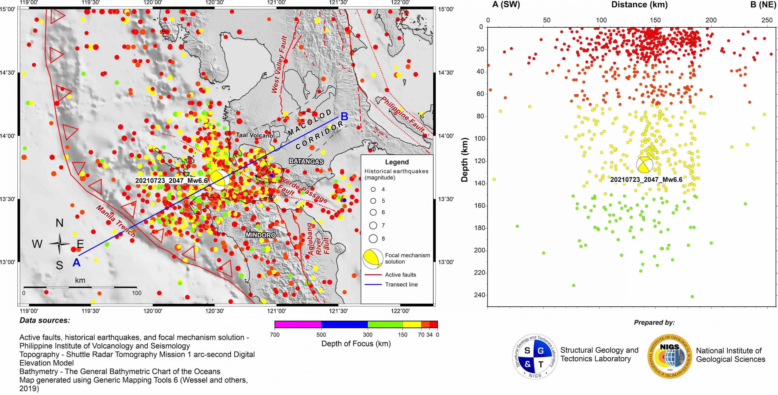
The Lubang-Verde Passage fault system is a major strike-slip fault system located offshore between the Batangas and Mindoro Island in the Philippines. [1]

Background

The fault follows the northwest-southeast alignment of Verde and Lubang islands and is primarily considered a left-lateral fault, meaning the two sides of the fault move horizontally past each other in opposite directions. This geological feature is associated with seismic activity, giving rise to earthquakes of varying magnitudes. Notably, on July 24, 2021, the fault was responsible for the Calatagan earthquake, which registered a magnitude of 6.6. The region's tectonic dynamics, marked by the lateral motion along this fault, contribute to the occurrence of significant seismic events such as the mentioned earthquake. [2] [3]

Related Research Articles

<span class="mw-page-title-main">Queen Charlotte Fault</span> Active transform fault in Canada and Alaska

The Queen Charlotte Fault is an active transform fault that marks the boundary of the North American plate and the Pacific plate. It is Canada's right-lateral strike-slip equivalent to the San Andreas Fault to the south in California. The Queen Charlotte Fault forms a triple junction south with the Cascadia subduction zone and the Explorer Ridge. The Queen Charlotte Fault (QCF) forms a transpressional plate boundary, and is as active as other major transform fault systems in terms of slip rates and seismogenic potential. It sustains the highest known deformation rates among continental or continent-ocean transform systems globally, accommodating greater than 50mm/yr dextral offset. The entire approximately 900 km offshore length has ruptured in seven greater than magnitude 7 events during the last century, making the cumulative historical seismic moment release higher than any other modern transform plate boundary system.

The 1933 Baffin Bay earthquake struck Greenland and the Northwest Territories, Canada with a moment magnitude of 7.4 at 18:21:35 Eastern Time Zone on November 20.

The 2009 Swan Islands earthquake occurred on May 28 at 02:24:45 AM local time with a moment magnitude of 7.3 and a maximum Mercalli intensity of VII. The epicenter was located in the Caribbean Sea, 64 kilometres (40 mi) northeast of the island of Roatán, 19 miles northeast of Port Royal, Isla de Bahias, 15 miles northwest of Isla Barbaretta, and 130 kilometres (81 mi) north-northeast of La Ceiba. Three aftershocks followed the earthquake within magnitude 4 range.

The Philippine Fault System is a major inter-related system of geological faults throughout the whole of the Philippine Archipelago, primarily caused by tectonic forces compressing the Philippines into what geophysicists call the Philippine Mobile Belt. Some notable Philippine faults include the Guinayangan, Masbate and Leyte faults.

<span class="mw-page-title-main">Wairarapa Fault</span> Active seismic fault in New Zealand

The Wairarapa Fault is an active seismic fault in the southern part of the North Island of New Zealand. It is a dextral strike-slip fault with a component of uplift to the northwest as expressed by the Rimutaka Range. It forms part of the North Island Fault System, which accommodates the transfer of displacement along the oblique convergent boundary between the Indo-Australian Plate and Pacific Plate.

Mae Chan Fault is an active 118 km long west-southwest–east-northeast trending left lateral strike-slip fault in Northern Thailand that extends into western Laos. It was responsible for a 6.3 magnitude quake in Laos on May 16, 2007, that caused property damage as far as Chiang Rai in Thailand. A part of it stretches from Mae Chan to Mae Ai for 40 km along the highway, then goes through Fang, Chiang Dao, Mae Rim and San Kamphaeng districts of Chiang Mai, to Mae Tha district of Lamphun.

<span class="mw-page-title-main">Sagaing Fault</span> Seismic fault in Myanmar

The Sagaing Fault is a major fault in Myanmar, a mainly continental right-lateral transform fault between the Indian Plate and Sunda Plate. It links the divergent boundary in the Andaman Sea with the zone of active continental collision along the Himalayan front. It passes through the populated cities of Mandalay, Yamethin, Pyinmana, the capital Naypyidaw, Toungoo and Pegu before dropping off into the Gulf of Martaban, running for a total length of over 1200 kilometers.

<span class="mw-page-title-main">1994 Mindoro earthquake</span> Earthquake in the Philippines

The 1994 Mindoro earthquake occurred at 03:15:30 PST on November 15 near Mindoro, Philippines. It had a moment magnitude of 7.1 and a maximum Rossi–Forel of VII. It is associated with a 35-kilometer-long (22 mi) ground rupture, called the Aglubang River fault. Seventy eight people were reported dead, and 7,566 houses were damaged. The earthquake generated a tsunami and landslides on the Verde Island.

<span class="mw-page-title-main">Cape Santiago</span>

Cape Santiago is the southwestern point of the island of Luzon located within the municipality of Calatagan in Batangas, Philippines. It is a cape at the southern tip of Calatagan Peninsula which faces the South China Sea to the west and Pagapas Bay, an arm of Balayan Bay, to the east. The cape has been the site of a navigational aid since the 1890s.

The 2000 Nicaragua earthquake occurred at 19:30 UTC on July 6. It had a magnitude of 5.4 on the moment magnitude scale and caused 7 deaths and 42 injuries. 357 houses were destroyed and 1,130 others were damaged in the earthquake.

<span class="mw-page-title-main">Bohol Fault System</span>

Bohol Fault System is a reverse fault system in Bohol province, Philippines. This fault system contains 3 segments: the newly found North Bohol Fault following the 2013 Bohol earthquake, the South Offshore Fault, and the East Bohol Fault.

The 2017 Surigao earthquake occurred on February 10, 2017, at 10:03 PM (PST), with a surface wave magnitude of 6.7 off the coast of Surigao del Norte in the Philippines. According to the PHIVOLCS Earthquake Intensity Scale the earthquake was an Intensity VII (Destructive) earthquake at maximum. In the past Surigao province has been hit by a magnitude 7.2 tremor in both 1879 and 1893.

<span class="mw-page-title-main">Subduction tectonics of the Philippines</span>

The subduction tectonics of the Philippines is the control of geology over the Philippine archipelago. The Philippine region is seismically active and has been progressively constructed by plates converging towards each other in multiple directions. The region is also known as the Philippine Mobile Belt due to its complex tectonic setting.

The 2020 Central Idaho earthquake occurred in the western United States on March 31, 2020, at 5:52 PM MDT, near Ruffneck Peak in the Sawtooth Mountains of central Idaho, 72 miles (116 km) northeast of Boise and 19 miles (31 km) northwest of Stanley. It had a magnitude of 6.5 and was felt with a maximum intensity of VIII.

The 1994 Mascara earthquake occurred on August 18 at 02:13 local time with an epicenter in a rural part of Algeria. The earthquake measured 5.8 on the moment magnitude scale (Mw ) and had a depth of 10 km (6.2 mi). It caused the deaths of 171 people, left up to 12,500 homeless, and destroyed thousands of homes in Mascara Province. Many homes were damaged or destroyed due to poor building quality which collapsed on the inhabitants and resulted in a majority of the casualties. The national government launched a rapid response effort in its aftermath.

<span class="mw-page-title-main">2021 Chignik earthquake</span> 7th largest earthquake in the US

An earthquake occurred off the coast of the Alaska Peninsula on July 28, 2021, at 10:15 p.m. local time. The large megathrust earthquake had a moment magnitude of 8.2 according to the United States Geological Survey (USGS). A tsunami warning was issued by the National Oceanic and Atmospheric Administration (NOAA) but later cancelled. The mainshock was followed by a number of aftershocks, including three that were of magnitude 5.9, 6.1 and 6.9 respectively.

The 2021 Loyalty Islands earthquake was a 7.7 magnitude earthquake that struck offshore between Vanuatu and New Caledonia on February 11, 2021 at 00:19 local time. It is the 4th largest earthquake of 2021.

The 2016 Alborian Sea earthquake struck offshore, north northeast of Al Hoceïma, Morocco in the Strait of Gibraltar on January 25 at 04:22:02 UTC, or roughly 05:22:02 West Africa Time. At its strongest in the Alboran Sea, the earthquake measured 6.3–6.4 on the moment magnitude scale (Mw ) at a shallow hypocenter depth of 12 km (7.5 mi). Assigned a maximum Modified Mercalli scale intensity of VI (Strong), the earthquake caused one fatality, injuries to at least 30 persons, and moderate damage in Morocco and Spain.

The 1879 Surigao earthquake occurred on June 30 at 18:38 02:55 local time on the northeastern tip of Mindanao. The earthquake with a moment magnitude (Mw ) of 7.4 struck with an epicenter just south of Lake Mainit. Extensive damage occurred but there were no reports of casualties.

The 1983 Kaoiki earthquake struck southern Hawaii Island on the morning of November 16, 1983. Measuring Mw  6.7, it was the largest to hit the island since 1975. The epicenter was located 50 km (30 mi) southeast of Hilo with an approximated depth of 12 km (7 mi). The shallow strike-slip earthquake was assigned a maximum intensity of IX (Violent) on the Modified Mercalli scale. 6 people were injured, widespread damage and landslides were reported across the island.

References

  1. "Figure 2 - Seismotectonics of the July 24, 2021, magnitude-6.6 earthquake of Calatagan, Batangas, Philippines. Among the active strike-slip faults include the west/northwest-striking sinistral Lubang-Verde Passage Fault, and the north/northwest-striking dextral Aglubang River Fault on Mindoro Island. Located to the northeast of the Calatagan earthquake epicenter is the Macolod Corridor, a northeast-trending structural depression that hosts numerous active volcanic centers including Taal Volcano. Credit: Aurelio, Lagmay, Escudero and Catugas". Temblor.net. 2021-07-27. Retrieved 2024-01-25.
  2. "INTERNATIONAL SOCIETY FOR SOIL MECHANICS AND GEOTECHNICAL ENGINEERING" (PDF). issmge.org. Retrieved 4 February 2024.
  3. Sarmiento, Keanu Jershon S.; Aurelio, Mario A.; Flores, Paul Caesar M.; Carrillo, Anne Drew V.; Marfito, Bryan J.; Abigania, Maria Isabel T.; Daag, Arturo S.; Siringan, Fernando P. (2022). "Seafloor Structures and Static Stress Changes Associated With Two Recent Earthquakes in Offshore Southern Batangas, Philippines". Frontiers in Earth Science. 9: 1416. Bibcode:2022FrEaS...9.1416S. doi: 10.3389/feart.2021.801670 . ISSN   2296-6463.