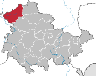
Hochsauerlandkreis is a Kreis (district) in the east of North Rhine-Westphalia, Germany. Neighboring districts are Soest, Paderborn, Höxter, Waldeck-Frankenberg, Siegen-Wittgenstein, Olpe, Märkischer Kreis.
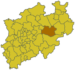
Soest is a Kreis (district) in the middle of North Rhine-Westphalia, Germany. Neighbouring districts are Warendorf, Gütersloh, Paderborn, Hochsauerland, Märkischer Kreis, Unna and the independent town of Hamm.

Arnsberg is one of the five Regierungsbezirks of North Rhine-Westphalia, Germany, located in the south-east of the country. It covers the Sauerland hills as well as the east part of the Ruhr area.
Eichsfeld is a district in Thuringia, Germany, and part of the historical region of Eichsfeld. It is bounded by the districts of Nordhausen, Kyffhäuserkreis and Unstrut-Hainich-Kreis, and by the states of Hesse and Lower Saxony.
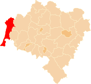
Zgorzelec County is a unit of territorial administration and local government (powiat) in Lower Silesian Voivodeship, Poland. It came into being on January 1, 1999, as a result of the Polish local government reforms passed in 1998. It is situated in the extreme south-west of Poland, bordering both Germany and the Czech Republic. The county covers an area of 838.1 square kilometres (323.6 sq mi). Its administrative seat is Zgorzelec, on the German border; the other towns in the county are Bogatynia, Pieńsk, Zawidów and Węgliniec.

Zeebrugge is a village on the coast of Belgium and a subdivision of Bruges, for which it is the modern port. Zeebrugge serves as both the international port of Bruges-Zeebrugge and a seafront resort with hotels, cafés, a marina and a beach.

The Rheinstadion was a multi-purpose stadium, in Düsseldorf, Germany. The stadium was built, near the Rhine, in 1926 and held 55,900 people, at the end of its life.

The Bergisch Gladbach Observatory is an astronomical observatory located in Bergisch Gladbach, Germany, at 51°05′15.4″N7°29′08.8″E. Its observatory code is 621. Astronomer Wolf Bickel.
Thierbach Power Station was a brown coal-fired power station in the Leipzig Bay at Espenhain-Thierbach, Germany. It had a 300-metre-tall chimney, which belonged to the tallest free-standing structures of the former GDR.
German submarine U-362 was a Type VIIC U-boat built for Nazi Germany's Kriegsmarine for service during World War II.

Kożuchów is a town in Lubusz Voivodeship, Poland.

Advanced Landing Grounds (ALGs) were temporary advance airfields constructed by the Allies during World War II during the liberation of Europe. They were built in the UK prior to the invasion and thereafter in northwest Europe from 6 June 1944 to V-E Day, 7 May 1945.
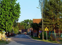
Ershausen/Geismar is a municipal association in the district of Eichsfeld, in Thuringia, Germany. The seat of the municipal association is in Schimberg.
Germany is a country in west-central Europe, that stretches from the Alps, across the North European Plain to the North Sea and the Baltic Sea. Germany has the second largest population in Europe and is seventh largest in area. The territory of Germany covers 357,021 km2 (137,847 sq mi), consisting of 349,223 km2 (134,836 sq mi) of land and 7,798 km2 (3,011 sq mi) of waters.
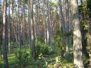
Lower Silesian Forest is the largest continuous forest of Poland, with total area of 1650 square kilometers. It is located in southwestern Poland, in the Lower Silesian Voivodeship and the Lubusz Voivodeship, near border with Germany. Western boundary of the forest is made by the Nysa Łużycka, behind which spreads a German forest, Muskauer Heide. It is mostly covered by pine trees.

Duchesse Anne is the last remaining full-rigged ship under French flag. She was built in 1901 with a steel hull by the yard of Joh. C. Tecklenborg of Bremerhaven-Geestemünde (Germany) according to plans drawn by Georg W. Claussen. The mainmast is 48 m tall and 25 sails were rigged. She was used as a training ship for young aspiring sailors in the German merchant marine.

Central Germany (Zentraldeutschland/Mitteldeutschland), in geography, describes the areas surrounding the geographical centre of Germany.
Erdgas Sportpark, is a stadium in Halle, Germany. It has a capacity of 15,057 spectators. It is the home of Hallescher FC and replaced Kurt-Wabbel-Stadion.

German submarine U-1008 was a Type VIIC/41 U-boat of Nazi Germany's Kriegsmarine during World War II.