Antonin is a village in the administrative district of Gmina Ciechanowiec, within Wysokie Mazowieckie County, Podlaskie Voivodeship, in north-eastern Poland. It lies approximately 4 kilometres (2 mi) east of Ciechanowiec, 27 km (17 mi) south of Wysokie Mazowieckie, and 64 km (40 mi) south-west of the regional capital Białystok.

Gródek is a village in the administrative district of Gmina Klukowo, within Wysokie Mazowieckie County, Podlaskie Voivodeship, in north-eastern Poland. It lies approximately 6 kilometres (4 mi) south-east of Klukowo, 21 km (13 mi) south of Wysokie Mazowieckie, and 60 km (37 mi) south-west of the regional capital Białystok.
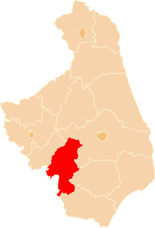
Klukowo is a village in Wysokie Mazowieckie County, Podlaskie Voivodeship, in north-eastern Poland. It is the seat of the gmina called Gmina Klukowo. It lies approximately 17 kilometres (11 mi) south of Wysokie Mazowieckie and 60 km (37 mi) south-west of the regional capital Białystok.
Kuczyn is a village in the administrative district of Gmina Klukowo, within Wysokie Mazowieckie County, Podlaskie Voivodeship, in north-eastern Poland. It lies approximately 23 kilometres (14 mi) south of Wysokie Mazowieckie and 62 km (39 mi) south-west of the regional capital Białystok.
Łuniewo Małe is a village in the administrative district of Gmina Klukowo, within Wysokie Mazowieckie County, Podlaskie Voivodeship, in north-eastern Poland. It lies approximately 21 kilometres (13 mi) south of Wysokie Mazowieckie and 64 km (40 mi) south-west of the regional capital Białystok.
Łuniewo Wielkie is a village in the administrative district of Gmina Klukowo, within Wysokie Mazowieckie County, Podlaskie Voivodeship, in north-eastern Poland. It lies approximately 20 kilometres (12 mi) south of Wysokie Mazowieckie and 63 km (39 mi) south-west of the regional capital Białystok.
Malinowo is a village in the administrative district of Gmina Klukowo, within Wysokie Mazowieckie County, Podlaskie Voivodeship, in north-eastern Poland. It lies approximately 5 kilometres (3 mi) south of Klukowo, 22 km (14 mi) south of Wysokie Mazowieckie, and 63 km (39 mi) south-west of the regional capital Białystok.
Sobolewo is a village in the administrative district of Gmina Klukowo, within Wysokie Mazowieckie County, Podlaskie Voivodeship, in north-eastern Poland. It lies approximately 4 kilometres (2 mi) north of Klukowo, 14 km (9 mi) south of Wysokie Mazowieckie, and 58 km (36 mi) south-west of the regional capital Białystok.
Stare Warele is a village in the administrative district of Gmina Klukowo, within Wysokie Mazowieckie County, Podlaskie Voivodeship, in north-eastern Poland. It lies approximately 17 kilometres (11 mi) south of Wysokie Mazowieckie and 54 km (34 mi) south-west of the regional capital Białystok.
Stare Zalesie is a village in the administrative district of Gmina Klukowo, within Wysokie Mazowieckie County, Podlaskie Voivodeship, in north-eastern Poland. It lies approximately 18 kilometres (11 mi) south of Wysokie Mazowieckie and 55 km (34 mi) south-west of the regional capital Białystok.
Trojanowo is a village in the administrative district of Gmina Klukowo, within Wysokie Mazowieckie County, Podlaskie Voivodeship, in north-eastern Poland. It lies approximately 3 kilometres (2 mi) south-east of Klukowo, 19 km (12 mi) south of Wysokie Mazowieckie, and 60 km (37 mi) south-west of the regional capital Białystok.
Usza Mała is a village in the administrative district of Gmina Klukowo, within Wysokie Mazowieckie County, Podlaskie Voivodeship, in north-eastern Poland. It lies approximately 21 kilometres (13 mi) south of Wysokie Mazowieckie and 64 km (40 mi) south-west of the regional capital Białystok.
Usza Wielka is a village in the administrative district of Gmina Klukowo, within Wysokie Mazowieckie County, Podlaskie Voivodeship, in north-eastern Poland. It lies approximately 23 kilometres (14 mi) south of Wysokie Mazowieckie and 65 km (40 mi) south-west of the regional capital Białystok.
Wiktorzyn is a village in the administrative district of Gmina Klukowo, within Wysokie Mazowieckie County, Podlaskie Voivodeship, in north-eastern Poland. It lies approximately 21 kilometres (13 mi) south of Wysokie Mazowieckie and 61 km (38 mi) south-west of the regional capital Białystok.
Wyszonki Kościelne is a village in the administrative district of Gmina Klukowo, within Wysokie Mazowieckie County, Podlaskie Voivodeship, in north-eastern Poland. It lies approximately 19 kilometres (12 mi) south of Wysokie Mazowieckie and 54 km (34 mi) south-west of the regional capital Białystok.
Żebry Wielkie is a village in the administrative district of Gmina Klukowo, within Wysokie Mazowieckie County, Podlaskie Voivodeship, in north-eastern Poland. It lies approximately 23 kilometres (14 mi) south of Wysokie Mazowieckie and 64 km (40 mi) south-west of the regional capital Białystok.
Grodzkie Szczepanowięta is a village in the administrative district of Gmina Kulesze Kościelne, within Wysokie Mazowieckie County, Podlaskie Voivodeship, in north-eastern Poland. It lies approximately 4 kilometres (2 mi) north-east of Kulesze Kościelne, 15 km (9 mi) north of Wysokie Mazowieckie, and 42 km (26 mi) west of the regional capital Białystok.
Koboski is a village in the administrative district of Gmina Nowe Piekuty, within Wysokie Mazowieckie County, Podlaskie Voivodeship, in north-eastern Poland. It lies approximately 4 kilometres (2 mi) north-east of Nowe Piekuty, 17 km (11 mi) east of Wysokie Mazowieckie, and 40 km (25 mi) south-west of the regional capital Białystok.
Krzyżewo is a village in the administrative district of Gmina Sokoły, within Wysokie Mazowieckie County, Podlaskie Voivodeship, in north-eastern Poland. It lies approximately 6 kilometres (4 mi) north-east of Sokoły, 21 km (13 mi) north-east of Wysokie Mazowieckie, and 30 km (19 mi) west of the regional capital Białystok.
Wróble is a village in the administrative district of Gmina Wysokie Mazowieckie, within Wysokie Mazowieckie County, Podlaskie Voivodeship, in north-eastern Poland. It lies approximately 5 kilometres (3 mi) north-east of Wysokie Mazowieckie and 46 km (29 mi) south-west of the regional capital Białystok.