Białystok County is a unit of territorial administration and local government (powiat) in Podlaskie Voivodeship, north-eastern Poland, on the border with Belarus. It was created on 1 January 1999 as a result of the Polish local government reforms passed in 1998. Its administrative seat is the city of Białystok, although the city is not part of the county.

Siemiatycze County is a unit of territorial administration and local government (powiat) in Podlaskie Voivodeship, north-eastern Poland, on the border with Belarus. It came into being on January 1, 1999, as a result of the Polish local government reforms passed in 1998. Its administrative seat and largest town is Siemiatycze, which lies 80 kilometres (50 mi) south of the regional capital Białystok. The only other town in the county is Drohiczyn, lying 15 km (9 mi) west of Siemiatycze.

Zambrów County is a unit of territorial administration and local government (powiat) in Podlaskie Voivodeship, north-eastern Poland. It came into being on January 1, 1999, as a result of the Polish local government reforms passed in 1998. Its administrative seat and only town is Zambrów, which lies 64 kilometres (40 mi) west of the regional capital Białystok.

Bielsk County is a unit of territorial administration and local government (powiat) in Podlaskie Voivodeship, north-eastern Poland. It came into being on 1 January 1999, as a result of the Polish local government reforms passed in 1998. Its administrative seat and largest town is Bielsk Podlaski, which lies 39 kilometres (24 mi) south of the regional capital Białystok. The only other town in the county is Brańsk, lying 25 km (16 mi) west of Bielsk Podlaski.

Ostrów Mazowiecka County is a unit of territorial administration and local government (powiat) in Masovian Voivodeship, east-central Poland. It came into being on January 1, 1999, as a result of the Polish local government reforms passed in 1998. Its administrative seat and largest town is Ostrów Mazowiecka, which lies 89 kilometres (55 mi) north-east of Warsaw. The only other town in the county is Brok, lying 12 km (7 mi) south of Ostrów Mazowiecka.

Sokołów County is a unit of territorial administration and local government (powiat) in Masovian Voivodeship, east-central Poland. It came into being on January 1, 1999, as a result of the Polish local government reforms passed in 1998. Its administrative seat and largest town is Sokołów Podlaski, which lies 88 kilometres (55 mi) east of Warsaw. The only other town in the county is Kosów Lacki, lying 23 km (14 mi) north of Sokołów Podlaski.
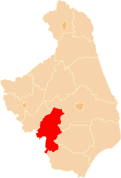
Gmina Ciechanowiec is an urban-rural gmina in Wysokie Mazowieckie County, Podlaskie Voivodeship, in north-eastern Poland. Its seat is the town of Ciechanowiec, which lies approximately 27 kilometres (17 mi) south of Wysokie Mazowieckie and 66 km (41 mi) south-west of the regional capital Białystok.
Gmina Czyżew is an urban-rural gmina in Wysokie Mazowieckie County, Podlaskie Voivodeship, in north-eastern Poland. Its seat is the town of Czyżew, which lies approximately 19 kilometres (12 mi) south-west of Wysokie Mazowieckie and 67 km (42 mi) south-west of the regional capital Białystok.
Gmina Klukowo is a rural gmina in Wysokie Mazowieckie County, Podlaskie Voivodeship, in north-eastern Poland. Its seat is the village of Klukowo, which lies approximately 17 kilometres (11 mi) south of Wysokie Mazowieckie and 60 km (37 mi) south-west of the regional capital Białystok.
Gmina Szepietowo is an urban-rural gmina in Wysokie Mazowieckie County, Podlaskie Voivodeship, in north-eastern Poland. Its seat is the town of Szepietowo, which lies approximately 6 kilometres (4 mi) south of Wysokie Mazowieckie and 51 km (32 mi) south-west of the regional capital Białystok.

Kułaki is a village in the administrative district of Gmina Ciechanowiec, within Wysokie Mazowieckie County, Podlaskie Voivodeship, in north-eastern Poland. It lies approximately 7 kilometres (4 mi) east of Ciechanowiec, 28 km (17 mi) south of Wysokie Mazowieckie, and 63 km (39 mi) south-west of the regional capital Białystok.
Malec is a village in the administrative district of Gmina Ciechanowiec, within Wysokie Mazowieckie County, Podlaskie Voivodeship, in north-eastern Poland. It lies approximately 7 kilometres (4 mi) south-east of Ciechanowiec, 31 km (19 mi) south of Wysokie Mazowieckie, and 65 km (40 mi) south-west of the regional capital Białystok.
Nowodwory is a village in the administrative district of Gmina Ciechanowiec, within Wysokie Mazowieckie County, Podlaskie Voivodeship, in north-eastern Poland. It lies approximately 4 kilometres (2 mi) west of Ciechanowiec, 27 km (17 mi) south of Wysokie Mazowieckie, and 69 km (43 mi) south-west of the regional capital Białystok.
Radziszewo Stare is a village in the administrative district of Gmina Ciechanowiec, within Wysokie Mazowieckie County, Podlaskie Voivodeship, in north-eastern Poland. It lies approximately 9 kilometres (6 mi) east of Ciechanowiec, 29 km (18 mi) south of Wysokie Mazowieckie, and 63 km (39 mi) south-west of the regional capital Białystok.
Dąbrowa Wielka is a village in the administrative district of Gmina Czyżew-Osada, within Wysokie Mazowieckie County, Podlaskie Voivodeship, in north-eastern Poland. It lies approximately 8 kilometres (5 mi) north-east of Czyżew-Osada, 11 km (7 mi) south-west of Wysokie Mazowieckie, and 60 km (37 mi) south-west of the regional capital Białystok.

Rosochate Kościelne is a village in the administrative district of Gmina Czyżew-Osada, within Wysokie Mazowieckie County, Podlaskie Voivodeship, in north-eastern Poland. It lies approximately 8 kilometres (5 mi) north of Czyżew-Osada, 13 km (8 mi) south-west of Wysokie Mazowieckie, and 62 km (39 mi) south-west of the regional capital Białystok.
Dąbrowa-Dołęgi is a village in the administrative district of Gmina Szepietowo, within Wysokie Mazowieckie County, Podlaskie Voivodeship, in north-eastern Poland. It lies approximately 4 kilometres (2 mi) west of Szepietowo, 7 km (4 mi) south of Wysokie Mazowieckie, and 54 km (34 mi) south-west of the regional capital Białystok.
Dąbrowa-Gogole is a village in the administrative district of Gmina Szepietowo, within Wysokie Mazowieckie County, Podlaskie Voivodeship, in north-eastern Poland. It lies approximately 9 kilometres (6 mi) west of Szepietowo, 11 km (7 mi) south-west of Wysokie Mazowieckie, and 59 km (37 mi) south-west of the regional capital Białystok.

Szepietowo is a town in Wysokie Mazowieckie County, Podlaskie Voivodeship, in north-eastern Poland. It is the seat of the gmina called Gmina Szepietowo. It lies approximately 6 kilometres (4 mi) south of Wysokie Mazowieckie and 51 km (32 mi) south-west of the regional capital Białystok.

Czyżew is a town in Wysokie Mazowieckie County, Podlaskie Voivodeship, in north-eastern Poland. It is the seat of the gmina called Gmina Czyżew. It lies approximately 19 kilometres (12 mi) south-west of Wysokie Mazowieckie and 67 km (42 mi) south-west of the regional capital Białystok.