Bielsk County

Last updated

Bielsk County
powiat bielski
POL powiat bielski (wojewodztwo podlaskie) flag.svg
POL powiat bielski (wojewodztwo podlaskie) COA.svg
POL powiat bielski (wojewodztwo podlaskie) map.svg
Bielsk County in Podlaskie Voivodeship
Bielsk County-Gminy.png
Gminy in Bielsk County
Coordinates(Bielsk Podlaski): 52°46′N23°12′E / 52.767°N 23.200°E / 52.767; 23.200
CountryFlag of Poland.svg  Poland
Voivodeship Podlaskie
Seat Bielsk Podlaski
Gminas
Government
   County Executive Slawomir Jerzy Snarski
Area
  Total1,385.2 km2 (534.8 sq mi)
Population
 (2019)
  Total54,590
  Density39/km2 (100/sq mi)
   Urban
29,057
  Rural
25,533
Time zone UTC+1 (CET)
  Summer (DST) UTC+2 (CEST)
Car plates BBI
Website http://www.powiatbielski.pl

Bielsk County (Polish : powiat bielski) is a unit of territorial administration and local government (powiat) in Podlaskie Voivodeship, north-eastern Poland. It came into being on 1 January 1999, as a result of the Polish local government reforms passed in 1998. Its administrative seat and largest town is Bielsk Podlaski, which lies 39 kilometres (24 mi) south of the regional capital Białystok. The only other town in the county is Brańsk, lying 25 km (16 mi) west of Bielsk Podlaski.

Contents

The county covers an area of 1,385.2 square kilometres (534.8 sq mi). As of 2019 its total population is 54,590, out of which the population of Bielsk Podlaski is 25,290, that of Brańsk is 3,767, and the rural population is 25,533. [1]

Neighbouring counties

Bielsk County is bordered by Białystok County to the north, Hajnówka County to the east, Siemiatycze County to the south and Wysokie Mazowieckie County to the west.

Administrative division

The county is subdivided into eight gminas (two urban and six rural). These are listed in the following table, in descending order of population.

Gimny in Bielsk County Bielsk County-Gminy.png
Gimny in Bielsk County
NumberGminaTypeArea
(km2)
Population
(2019)
Seat
1 Bielsk Podlaski urban26.925,290 
2 Gmina Bielsk Podlaski rural430.16,636 Bielsk Podlaski *
3 Gmina Brańsk rural227.35,672 Brańsk *
4 Gmina Boćki rural232.14,263 Boćki
5 Gmina Wyszki rural206.54,378 Wyszki
6 Brańsk urban32.43,767 
7 Gmina Orla rural159.72,708 Orla
8 Gmina Rudka rural70.21,876 Rudka
* seat not part of the gmina

History

15th century

On 18 January 1493, Brańsk received a city charter based on Magdeburg rights from the Grand Duke of Lithuania, Alexander Jagiellon. It was the first city in Podlaskie to receive such a charter.

On 18 November 1495, Bielsk Podlaski received a city charter based on Magdeburg rights from the Grand Duke of Lithuania, Alexander Jagiellon.

16th century

On 1 July 1569, the Union of Lublin was signed between the Grand Duchy of Lithuania and the Kingdom of Poland forming the Polish–Lithuanian Commonwealth. One of the terms of the treaty transferred the Podlaskie Voivodeship from the Grand Duchy of Lithuania to the Polish Crown.

18th century

On 24 October 1795, the Third Partition of Poland assigned Bielsk County and most of Podlaskie to Prussia

19th century

Administrative division 1807-42 Belostok Oblast 1807-1842.png
Administrative division 1807–42

On 7–9 July 1807, the Treaties of Tilsit were signed between Imperial Russia, the First French Empire and Prussia. The treaties repartitioned former Polish territory and assigned Bielsk County and most of eastern Podlaskie from Prussia to Imperial Russia.

It was, from 1796 to 1915, subdivided into 8 Volost.

20th century

On 15 August 1915, the Gorlice-Tarnów Offensive by the German forces on the Eastern Front of World War I caused Bielsk County to come under the control of the German Empire.

On 5 November 1916, a declaration by the German Empire and the Austro-Hungarian Empire, promised the creation of the Kingdom of Poland in the areas of Poland controlled by the German Empire, including Bielsk County.

On 3 March 1918, the Treaty of Brest-Litovsk was signed between the Russian SFSR and the Central Powers. Bielsk County was assigned to the Kingdom of Poland

On 28 June 1919, the Treaty of Versailles and the Little Treaty of Versailles were signed establishing the Second Polish Republic. Bielsk County was assigned to Poland.

From 15 September 1939 to 23 September 1939 Bielsk County was occupied by German troops

From 23 September 1939 to 22 June 1941 occupation by the Red Army.

Following the start of Operation Barbarossa, 22 June 1941 to 30 July 1944, Bielsk County was occupied by the German Army.

On 30 July 1944 Bielsk County was re-occupied by the Red Army.

On 5 February 1946, the Border Agreement between Poland and the USSR of 16 August 1945 was ratified by Poland and the USSR. The agreement assigned Bielsk County to Poland.

Related Research Articles

<span class="mw-page-title-main">Białystok Voivodeship (1975–1998)</span>

Białystok Voivodeship was a unit of administrative division and local government in Poland from 1975 to 1998, when it was superseded by the Podlaskie Voivodeship. Its capital city was Białystok. It was formed in 1975 from part of the existing Białystok Voivodeship. The region was 10,055 km2 (3,882 sq mi), and its population in 1994, about 700 000 inhabitants. It was divided into 20 cities and 50 municipalities. It bordered with four Voivodeships: Suwałki, Łomża, Siedlce and Biała Podlaska and until 1991 with the Soviet Union, and later with Belarus.

<span class="mw-page-title-main">Bielsk Podlaski</span> Place in Podlaskie Voivodeship, Poland

Bielsk Podlaski is a town in eastern Poland, within Bielsk County in the Podlaskie Voivodeship. As of December 2021, the town has a population of 24,883.

<span class="mw-page-title-main">Hajnówka</span> Place in Podlaskie Voivodeship, Poland

Hajnówka is a town and a powiat seat in eastern Poland with 21,442 inhabitants (2014). It is the capital of Hajnówka County. The town is also notable for its proximity to the Białowieża Forest, the biggest primaeval forest in Europe. Through Hajnówka flows the river Leśna Prawa. It is one of the centres of Orthodox faith and a notable centre of Belarusian culture in Poland. Belarusians comprised 26.4% of the town's population in 2002.

<span class="mw-page-title-main">Drohiczyn</span> Place in Podlaskie Voivodeship, Poland

Drohiczyn is a town in Siemiatycze County, Podlaskie Voivodeship, Poland. The town has a population of 2,110 and is situated on the bank of the Bug River. Drohiczyn has a long and rich history, as in the past it was one of the most important cities of the region of Podlachia. Currently, it is the seat of Roman Catholic Diocese of Drohiczyn.

<span class="mw-page-title-main">Suraż</span> Place in Podlaskie Voivodeship, Poland

Suraż is a town in north-eastern Poland situated in the Podlaskie Voivodeship, seat of Gmina Suraż in the Białystok County.

<span class="mw-page-title-main">Brańsk</span> Place in Podlaskie Voivodeship, Poland

Brańsk is a town in eastern Poland. It is situated within Podlaskie Voivodeship (province).

<span class="mw-page-title-main">New East Prussia</span> Province of the Kingdom of Prussia (1795-1807)

New East Prussia was a province of the Kingdom of Prussia from 1795 to 1807. It was created out of territory annexed in the Third Partition of the Polish–Lithuanian Commonwealth and included parts of Masovia, Podlaskie, Trakai voivodeship and Žemaitija. In 1806 it had 914,610 inhabitants with a territory of less than 55,000 km2 (21,000 sq mi), mainly Poles, Lithuanians, Jews and Belarusians.

<span class="mw-page-title-main">Podlachia</span> Place in Poland

Podlachia, or Podlasie, is a historical region in the north-eastern part of Poland. Between 1513 and 1795 it was a voivodeship with the capital in Drohiczyn. Now the part north of the Bug River is included in the modern Podlaskie Voivodeship with the capital in Białystok.

<span class="mw-page-title-main">Mielnik</span> Village in Podlaskie Voivodeship, Poland

Mielnik is a village in Siemiatycze County, Podlaskie Voivodeship, in north-eastern Poland, close to the border with Belarus. It is the seat of the gmina called Gmina Mielnik. It lies approximately 17 kilometres (11 mi) south-east of Siemiatycze and 88 km (55 mi) south of the regional capital Białystok.

Glinnik is a village in the administrative district of Gmina Brańsk, within Bielsk County, Podlaskie Voivodeship, in north-eastern Poland. It lies approximately 7 kilometres (4 mi) north of Brańsk, 28 km (17 mi) west of Bielsk Podlaski, and 43 km (27 mi) south-west of the regional capital Białystok.

<span class="mw-page-title-main">Podlaskie Voivodeship (1513–1795)</span> Voivodeship of the Grand Duchy of Lithuania then of the Kingdom of Poland

The Podlaskie Voivodeship was formed in 1513 by Sigismund I the Old as a voivodeship in the Grand Duchy of Lithuania, from a split off part of the Trakai Voivodeship. After Lithuania's union with the Kingdom of Poland in 1569 and formation of the Polish–Lithuanian Commonwealth, the voivodeship was transferred to the Polish Crown, where it belonged to the Lesser Poland Province of the Polish Crown.

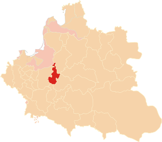
Gmina Brańsk is a rural gmina in Bielsk County, Podlaskie Voivodeship. It is located in north-eastern Poland.

<span class="mw-page-title-main">Gmina Wyszki</span> Gmina in Podlaskie Voivodeship, Poland

Gmina Wyszki is a rural gmina in Bielsk County, Podlaskie Voivodeship. It is located in north-eastern Poland.
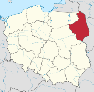
<span class="mw-page-title-main">Podlaskie Voivodeship</span> Voivodeship of Poland

Podlaskie Voivodeship or Podlasie Province is a voivodeship (province) in northeastern Poland. The name of the province refers to the historical region of Podlachia, and part of its territory corresponds to this region. The capital and largest city is Białystok.

Mień is a village in the administrative district of Gmina Brańsk, within Bielsk County, Podlaskie Voivodeship, in eastern Poland. It lies approximately 10 kilometres (6 mi) west of Brańsk, 34 km (21 mi) west of Bielsk Podlaski, and 50 km (31 mi) south-west of the regional capital Białystok.

Oleksin is a village in the administrative district of Gmina Brańsk, within Bielsk County, Podlaskie Voivodeship, in north-eastern Poland. It lies approximately 8 kilometres (5 mi) south-east of Brańsk, 22 km (14 mi) west of Bielsk Podlaski, and 50 km (31 mi) south of the regional capital Białystok.

Pietraszki is a village in the administrative district of Gmina Brańsk, within Bielsk County, Podlaskie Voivodeship, in north-eastern Poland. It lies approximately 8 kilometres (5 mi) north-west of Brańsk, 30 km (19 mi) west of Bielsk Podlaski, and 45 km (28 mi) south-west of the regional capital Białystok.

Świrydy is a village in the administrative district of Gmina Brańsk, within Bielsk County, Podlaskie Voivodeship, in north-eastern Poland. It lies approximately 6 kilometres (4 mi) north of Brańsk, 23 km (14 mi) west of Bielsk Podlaski, and 41 km (25 mi) south-west of the regional capital Białystok.

Załuskie Koronne is a village in the administrative district of Gmina Brańsk, within Bielsk County, Podlaskie Voivodeship, in north-eastern Poland. It lies approximately 7 kilometres (4 mi) north-east of Brańsk, 20 km (12 mi) west of Bielsk Podlaski, and 41 km (25 mi) south-west of the regional capital Białystok.

Bielsk Land, was an administrative unit (ziemia) of the Grand Duchy of Lithuania, Kingdom of Poland and the Polish–Lithuanian Commonwealth. Created in 1413, it originally belonged to the Lithuanian Trakai Voivodeship. In 1513, it became part of newly created Podlasie Voivodeship, and from 1569 until 1795, it belonged to the Kingdom of Poland.

References

  1. GUS. "Population. Size and structure and vital statistics in Poland by territorial division in 2019. As of 30th June". stat.gov.pl. Retrieved 14 September 2020.