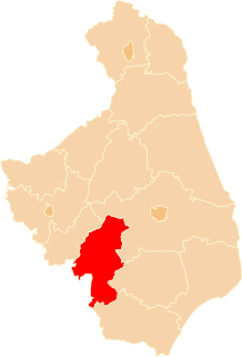
Gmina Czyżew is an urban-rural gmina in Wysokie Mazowieckie County, Podlaskie Voivodeship, in north-eastern Poland. Its seat is the town of Czyżew, which lies approximately 19 kilometres (12 mi) south-west of Wysokie Mazowieckie and 67 km (42 mi) south-west of the regional capital Białystok.
Gmina Kulesze Kościelne is a rural gmina in Wysokie Mazowieckie County, Podlaskie Voivodeship, in north-eastern Poland. Its seat is the village of Kulesze Kościelne, which lies approximately 13 kilometres (8 mi) north of Wysokie Mazowieckie and 46 km (29 mi) west of the regional capital Białystok.
Gmina Nowe Piekuty is a rural gmina in Wysokie Mazowieckie County, Podlaskie Voivodeship, in north-eastern Poland. Its seat is the village of Nowe Piekuty, which lies approximately 15 kilometres (9 mi) south-east of Wysokie Mazowieckie and 43 km (27 mi) south-west of the regional capital Białystok.
Gmina Szepietowo is an urban-rural gmina in Wysokie Mazowieckie County, Podlaskie Voivodeship, in north-eastern Poland. Its seat is the town of Szepietowo, which lies approximately 6 kilometres (4 mi) south of Wysokie Mazowieckie and 51 km (32 mi) south-west of the regional capital Białystok.
Gmina Wysokie Mazowieckie is a rural gmina in Wysokie Mazowieckie County, Podlaskie Voivodeship, in north-eastern Poland. Its seat is the town of Wysokie Mazowieckie, although the town is not part of the territory of the gmina.

Klukowo is a village in Wysokie Mazowieckie County, Podlaskie Voivodeship, in north-eastern Poland. It is the seat of the gmina called Gmina Klukowo. It lies approximately 17 kilometres (11 mi) south of Wysokie Mazowieckie and 60 km (37 mi) south-west of the regional capital Białystok.
Lubowicz Wielki is a village in the administrative district of Gmina Klukowo, within Wysokie Mazowieckie County, Podlaskie Voivodeship, in north-eastern Poland. It lies approximately 4 kilometres (2 mi) south-east of Klukowo, 19 km (12 mi) south of Wysokie Mazowieckie, and 59 km (37 mi) south-west of the regional capital Białystok.
Lubowicz-Byzie is a village in the administrative district of Gmina Klukowo, within Wysokie Mazowieckie County, Podlaskie Voivodeship, in north-eastern Poland.
Łuniewo Wielkie is a village in the administrative district of Gmina Klukowo, within Wysokie Mazowieckie County, Podlaskie Voivodeship, in north-eastern Poland. It lies approximately 20 kilometres (12 mi) south of Wysokie Mazowieckie and 63 km (39 mi) south-west of the regional capital Białystok.
Piętki-Żebry is a village in the administrative district of Gmina Klukowo, within Wysokie Mazowieckie County, Podlaskie Voivodeship, in north-eastern Poland.
Sobolewo is a village in the administrative district of Gmina Klukowo, within Wysokie Mazowieckie County, Podlaskie Voivodeship, in north-eastern Poland. It lies approximately 4 kilometres (2 mi) north of Klukowo, 14 km (9 mi) south of Wysokie Mazowieckie, and 58 km (36 mi) south-west of the regional capital Białystok.
Stare Warele is a village in the administrative district of Gmina Klukowo, within Wysokie Mazowieckie County, Podlaskie Voivodeship, in north-eastern Poland. It lies approximately 17 kilometres (11 mi) south of Wysokie Mazowieckie and 54 km (34 mi) south-west of the regional capital Białystok.
Stare Zalesie is a village in the administrative district of Gmina Klukowo, within Wysokie Mazowieckie County, Podlaskie Voivodeship, in north-eastern Poland. It lies approximately 18 kilometres (11 mi) south of Wysokie Mazowieckie and 55 km (34 mi) south-west of the regional capital Białystok.
Usza Mała is a village in the administrative district of Gmina Klukowo, within Wysokie Mazowieckie County, Podlaskie Voivodeship, in north-eastern Poland. It lies approximately 21 kilometres (13 mi) south of Wysokie Mazowieckie and 64 km (40 mi) south-west of the regional capital Białystok.
Usza Wielka is a village in the administrative district of Gmina Klukowo, within Wysokie Mazowieckie County, Podlaskie Voivodeship, in north-eastern Poland. It lies approximately 23 kilometres (14 mi) south of Wysokie Mazowieckie and 65 km (40 mi) south-west of the regional capital Białystok.
Wyszonki Kościelne is a village in the administrative district of Gmina Klukowo, within Wysokie Mazowieckie County, Podlaskie Voivodeship, in north-eastern Poland. It lies approximately 19 kilometres (12 mi) south of Wysokie Mazowieckie and 54 km (34 mi) south-west of the regional capital Białystok.
Wyszonki-Włosty is a village in the administrative district of Gmina Klukowo, within Wysokie Mazowieckie County, Podlaskie Voivodeship, in north-eastern Poland. It lies approximately 7 kilometres (4 mi) east of Klukowo, 20 km (12 mi) south of Wysokie Mazowieckie, and 56 km (35 mi) south-west of the regional capital Białystok.
Żebry Wielkie is a village in the administrative district of Gmina Klukowo, within Wysokie Mazowieckie County, Podlaskie Voivodeship, in north-eastern Poland. It lies approximately 23 kilometres (14 mi) south of Wysokie Mazowieckie and 64 km (40 mi) south-west of the regional capital Białystok.