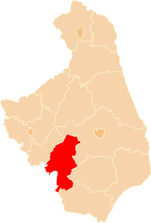
Gmina Czyżew is an urban-rural gmina in Wysokie Mazowieckie County, Podlaskie Voivodeship, in north-eastern Poland. Its seat is the town of Czyżew, which lies approximately 19 kilometres (12 mi) south-west of Wysokie Mazowieckie and 67 km (42 mi) south-west of the regional capital Białystok.
Gmina Kobylin-Borzymy is a rural gmina in Wysokie Mazowieckie County, Podlaskie Voivodeship, in north-eastern Poland. Its seat is the village of Kobylin-Borzymy, which lies approximately 21 kilometres (13 mi) north-east of Wysokie Mazowieckie and 34 km (21 mi) west of the regional capital Białystok.
Gmina Wysokie Mazowieckie is a rural gmina in Wysokie Mazowieckie County, Podlaskie Voivodeship, in north-eastern Poland. Its seat is the town of Wysokie Mazowieckie, although the town is not part of the territory of the gmina.
Gmina Zambrów is a rural gmina in Zambrów County, Podlaskie Voivodeship, in north-eastern Poland. Its seat is the town of Zambrów, although the town is not part of the territory of the gmina. Its largest village is Wola Zambrowska.

Jabłoń-Spały is a village in the administrative district of Gmina Nowe Piekuty, within Wysokie Mazowieckie County, Podlaskie Voivodeship, in north-eastern Poland. It lies approximately 10 kilometres (6 mi) north-west of Nowe Piekuty, 10 km (6 mi) east of Wysokie Mazowieckie, and 41 km (25 mi) south-west of the regional capital Białystok.

Dąbrowa-Gogole is a village in the administrative district of Gmina Szepietowo, within Wysokie Mazowieckie County, Podlaskie Voivodeship, in north-eastern Poland. It lies approximately 9 kilometres (6 mi) west of Szepietowo, 11 km (7 mi) south-west of Wysokie Mazowieckie, and 59 km (37 mi) south-west of the regional capital Białystok.

Dąbrowa-Moczydły is a village in the administrative district of Gmina Szepietowo, within Wysokie Mazowieckie County, Podlaskie Voivodeship, in north-eastern Poland. It lies approximately 4 kilometres (2 mi) south-west of Szepietowo, 9 km (6 mi) south of Wysokie Mazowieckie, and 55 km (34 mi) south-west of the regional capital Białystok.
Moczydły-Jakubowięta is a village in the administrative district of Gmina Szepietowo, within Wysokie Mazowieckie County, Podlaskie Voivodeship, in north-eastern Poland.

Nowe Gierałty is a village in the administrative district of Gmina Szepietowo, within Wysokie Mazowieckie County, Podlaskie Voivodeship, in north-eastern Poland. It lies approximately 3 kilometres (2 mi) south-east of Szepietowo, 9 km (6 mi) south of Wysokie Mazowieckie, and 51 km (32 mi) south-west of the regional capital Białystok.
Nowe Szepietowo Podleśne is a village in the administrative district of Gmina Szepietowo, within Wysokie Mazowieckie County, Podlaskie Voivodeship, in north-eastern Poland.

Nowe Warele is a village in the administrative district of Gmina Szepietowo, within Wysokie Mazowieckie County, Podlaskie Voivodeship, in north-eastern Poland. It lies approximately 10 kilometres (6 mi) south-east of Szepietowo, 16 km (10 mi) south-east of Wysokie Mazowieckie, and 52 km (32 mi) south-west of the regional capital Białystok.

Stary Kamień is a village in the administrative district of Gmina Szepietowo, within Wysokie Mazowieckie County, Podlaskie Voivodeship, in north-eastern Poland. It lies approximately 7 kilometres (4 mi) west of Szepietowo, 8 km (5 mi) south-west of Wysokie Mazowieckie, and 56 km (35 mi) south-west of the regional capital Białystok.

Stawiereje Podleśne is a village in the administrative district of Gmina Szepietowo, within Wysokie Mazowieckie County, Podlaskie Voivodeship, in north-eastern Poland. It lies approximately 5 kilometres (3 mi) east of Szepietowo, 9 km (6 mi) south-east of Wysokie Mazowieckie, and 47 km (29 mi) south-west of the regional capital Białystok.

Szepietowo is a town in Wysokie Mazowieckie County, Podlaskie Voivodeship, in north-eastern Poland. It is the seat of the gmina called Gmina Szepietowo. It lies approximately 6 kilometres (4 mi) south of Wysokie Mazowieckie and 51 km (32 mi) south-west of the regional capital Białystok.

Szepietowo Podleśne is a village in the administrative district of Gmina Szepietowo, within Wysokie Mazowieckie County, Podlaskie Voivodeship, in north-eastern Poland. It lies approximately 3 kilometres (2 mi) south of Szepietowo, 8 km (5 mi) south of Wysokie Mazowieckie, and 52 km (32 mi) south-west of the regional capital Białystok.

Wojny-Pietrasze is a village in the administrative district of Gmina Szepietowo, within Wysokie Mazowieckie County, Podlaskie Voivodeship, in north-eastern Poland. It lies approximately 9 kilometres (6 mi) south of Szepietowo, 15 km (9 mi) south of Wysokie Mazowieckie, and 54 km (34 mi) south-west of the regional capital Białystok.
Wojny-Szuby Włościańskie is a village in the administrative district of Gmina Szepietowo, within Wysokie Mazowieckie County, Podlaskie Voivodeship, in north-eastern Poland.


