Kamieniec is a village in the administrative district of Gmina Zławieś Wielka, within Toruń County, Kuyavian-Pomeranian Voivodeship, in north-central Poland. It lies approximately 15 km (9 mi) east of Bydgoszcz and 28 km (17 mi) west of Toruń.
Krasne is a village in the administrative district of Gmina Janów, within Sokółka County, Podlaskie Voivodeship, in north-eastern Poland.
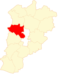
Florianów is a village in the administrative district of Gmina Bedlno, within Kutno County, Łódź Voivodeship, in central Poland. It lies approximately 12 kilometres (7 mi) east of Kutno and 50 km (31 mi) north of the regional capital Łódź.
Świnice is a village in the administrative district of Gmina Rawa Mazowiecka, within Rawa County, Łódź Voivodeship, in central Poland. It lies approximately 6 kilometres (4 mi) south-east of Rawa Mazowiecka and 57 km (35 mi) east of the regional capital Łódź.
Kaczowice is a village in the administrative district of Gmina Radziemice, within Proszowice County, Lesser Poland Voivodeship, in southern Poland.
Barycz is a village in the administrative district of Gmina Końskie, within Końskie County, Świętokrzyskie Voivodeship, in south-central Poland. It lies approximately 3 kilometres (2 mi) north of Końskie and 41 km (25 mi) north of the regional capital Kielce.
Załuski-Lipniewo is a village in the administrative district of Gmina Andrzejewo, within Ostrów Mazowiecka County, Masovian Voivodeship, in east-central Poland. It lies approximately 2 kilometres (1 mi) east of Andrzejewo, 23 km (14 mi) east of Ostrów Mazowiecka, and 108 km (67 mi) north-east of Warsaw.
Brzeście Nowe is a village in the administrative district of Gmina Baboszewo, within Płońsk County, Masovian Voivodeship, in east-central Poland.
Rowy is a village in the administrative district of Gmina Obryte, within Pułtusk County, Masovian Voivodeship, in east-central Poland.
Maków Nowy is a village in the administrative district of Gmina Skaryszew, within Radom County, Masovian Voivodeship, in east-central Poland.
Pindal is a village in the administrative district of Gmina Kampinos, within Warsaw West County, Masovian Voivodeship, in east-central Poland. It lies approximately 7 kilometres (4 mi) west of Kampinos, 31 km (19 mi) west of Ożarów Mazowiecki, and 45 km (28 mi) west of Warsaw.
Karolewice is a village in the administrative district of Gmina Kwilcz, within Międzychód County, Greater Poland Voivodeship, in west-central Poland.
Borowo is a village in the administrative district of Gmina Krzykosy, within Środa Wielkopolska County, Greater Poland Voivodeship, in west-central Poland. It lies approximately 7 kilometres (4 mi) north-west of Krzykosy, 11 km (7 mi) south of Środa Wielkopolska, and 39 km (24 mi) south-east of the regional capital Poznań.
Klasztor is a settlement in the administrative district of Gmina Lipnica, within Bytów County, Pomeranian Voivodeship, in northern Poland. It lies approximately 10 kilometres (6 mi) south-west of Lipnica, 25 km (16 mi) south-west of Bytów, and 99 km (62 mi) south-west of the regional capital Gdańsk.
Miłocin Drugi is a village in the administrative district of Gmina Cedry Wielkie, within Gdańsk County, Pomeranian Voivodeship, in northern Poland. It lies approximately 6 kilometres (4 mi) north-west of Cedry Wielkie, 12 km (7 mi) east of Pruszcz Gdański, and 15 km (9 mi) south-east of the regional capital Gdańsk.
Huta Górna is a village in the administrative district of Gmina Przywidz, within Gdańsk County, Pomeranian Voivodeship, in northern Poland. It lies approximately 3 kilometres (2 mi) north of Przywidz, 21 km (13 mi) west of Pruszcz Gdański, and 26 km (16 mi) south-west of the regional capital Gdańsk.
Wysin is a village in the administrative district of Gmina Liniewo, within Kościerzyna County, Pomeranian Voivodeship, in northern Poland. It lies approximately 5 kilometres (3 mi) north-east of Liniewo, 20 km (12 mi) east of Kościerzyna, and 38 km (24 mi) south-west of the regional capital Gdańsk.
Dybowo is a village in the administrative district of Gmina Prostki, within Ełk County, Warmian-Masurian Voivodeship, in northern Poland. It lies approximately 11 kilometres (7 mi) west of Prostki, 18 km (11 mi) south of Ełk, and 119 km (74 mi) east of the regional capital Olsztyn.
Sieniawa is a village in the administrative district of Gmina Drawno, within Choszczno County, West Pomeranian Voivodeship, in north-western Poland. It lies approximately 4 kilometres (2 mi) east of Drawno, 28 km (17 mi) east of Choszczno, and 84 km (52 mi) east of the regional capital Szczecin.
Muzeum i Instytut Zoologii PAN is a zoological museum in Warsaw, Poland. It was established in 1819. It is an institute of the Polish Academy of Sciences. It publishes the journal Acta Chiropterologica, a scientific journal on bats.