The Xiang River is the chief river of the Lake Dongting drainage system of the middle Yangtze, the largest river in Hunan Province, China. It is the 2nd largest tributary in terms of surface runoff, the 5th largest tributary by drainage area of the Yangtze tributaries. The river flows generally northeast through Guangxi and Hunan two provinces, its tributaries reach into Jiangxi and Guangdong.

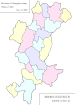
Yuelu District is one of six urban districts of Changsha City, Hunan province, China, it is the 4th most populous district in Hunan. The district is bordered to the north by Wangcheng District, to the west by Ningxiang County, to the south by Yuhu District of Xiangtan City, across the Xiang river to the west by Tianxin, Furong and Kaifu Districts. Located on the west bank of the Xiang River, as the western part of the City proper, the district is named after Mount Yuelu, one of the national parks, Yuelu District covers 538.83 km2 (208.04 sq mi) with registered population of 644,834 and resident population of 818,900. The district has 16 subdistricts and 2 towns under its jurisdiction, the government seat is at Wangyue (望岳街道).

The First Battle of Changsha was the first of four attempts by Japan to take the city of Changsha (長沙市), Hunan (湖南省), during the second Sino-Japanese War. It was the first major battle of the war to fall within the time frame of what is widely considered World War II.

The Battle of Changsha was Japan's second attempt at taking the city of Changsha, China, the capital of Hunan Province, as part of the Second Sino-Japanese War.

Changsha Huanghua International Airport is the airport serving Changsha, the capital of Hunan province, China, as well as nearby cities such as Zhuzhou and Xiangtan. As of 2016, it is the 13th busiest civil airport in China. Located about 25 kilometres (16 mi) from downtown Changsha in the town of Huanghua in Changsha County, the airport has two terminal buildings. The airport is managed by the Hunan Airport Authority, a publicly owned corporation managing all five airports in Hunan Province. Huanghua airport was opened in August 1989, replacing Changsha Datuopu Airport, which is now a military air base.
Miluo is a county-level city in Hunan province, China, it is under the administration of the prefecture-level city of Yueyang. The city is located on the northeast of the province and on the eastern bank of the Xiang River, it is to the north of the city proper of Changsha City. Miluo is bordered to the north by Yueyang County, to the east by Pingxiang County, to the south by Changsha County and Wangcheng District of Changsha City, to the west by Xiangyin County and Yuanjiang City. Miluo covers an area of 1,669.8 km2 (644.7 sq mi), as of 2015, it had a permanent resident population of 668,156. The city has 3 subdistricts and 10 towns under its jurisdiction. the government seat is Guiyi (归义镇).
Wangcheng District is one of six urban districts of Changsha, the capital of Hunan province, China. the district is bordered to the north by Miluo City and Xiangyin County of Yueyang, to the west by Heshan District of Yiyang and Ningxiang County, to the south by Yuelu and Kaifu Districts, to the east by Changsha County. Located in the northsouth of the City proper in Changsha, Wangcheng covers 951.06 km2 (367.21 sq mi) with registered population of 560,567 and resident population of 562,100. The district has 10 subdistricts and 5 towns under its jurisdiction, the government seat is at Gaotangling Subdistrict.
Furong District is one of six urban districts of Changsha, the capital of Hunan province, China. Furong District is a part of the core of the Changsha urban area, located in the midst of the city. The district is bordered by Yuhua District to the south, Changsha County to the east, Kaifu District to the northwest, Tianxin District to the southwest. Furong covers 42.68 km2 (16.48 sq mi) with population of 539,200, registered population of 403,948. The district has 13 subdistricts under its jurisdiction, the government seat is at Dongtundu subdistrict.
Kaifu District is one of six urban districts of Changsha, the capital of Hunan province, China. The district is bordered by Furong and Tianxin Districts to the south, Changsha County to the east and northeast, Wangcheng District to the north, Yuelu and Wangcheng Districts across the Xiang river to the west. Located in the central Changsha, Kaifu covers 188.73 km2 (72.87 sq mi) with population of 595,000, registered population of 452,168. The district has 16 subdistricts under its jurisdiction, the government seat is at Furongbeilu subdistrict.
Yuhua District is one of six urban districts of Changsha, Hunan province, China. the district is bordered by Yuetang District of Xiangtan to the south, Changsha County to the east, Furong District to the north, Tianxin District to the west. Located in the southern central Changsha, Yuhua covers 304.9 km2 (117.7 sq mi) with population of 764,700. The district has 12 subdistricts and 1 town under its jurisdiction, the government seat is at Guitang subdistrict.
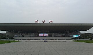
Changsha South railway station is a metro station and a railway station of Wuguang Passenger Railway and Hukun Passenger Railway. The station is located in Yuhua District, Changsha, Hunan, China.
It is a hub and the connecting point of Beijing–Guangzhou–Shenzhen–Hong Kong High-Speed Railway,
Shanghai–Kunming High-Speed Railway and the proposed Xiamen-Changsha-Chongqing High-Speed Railway.
The station, located in Lituo Street, Yuhua District, was opened Dec 26, 2009.
The designer of the station building is from the 3rd department of Central South Architectural Design Institute, INC. The roof features the waves and ripples of water. It has a total construction area of 273,000 square meters and the depot area is 137,000 square meters. It is a transportation center of high-speed railroads, metro lines 2&4,
buses, maglev and coaches, which can seamless connect with the downtown, Huanghua International Airport and cities in the vicinity.
Huanghua Town is a town in Changsha County, Changsha, Hunan province, China. It contains three communities and 20 villages.
It is the location of an airport.

Yong'an Town is a rural town in Liuyang City, Hunan Province, People's Republic of China. As of the 2015 census it had a population of 65,700 and an area of 112.1-square-kilometre (43.3 sq mi). It is surrounded by Shashi Town on the north, Beisheng Town on the east, Dongyang Town on the southeast, Chunhua Town of Changsha County on the west, and Jiangbei Town of Changsha County on the south.
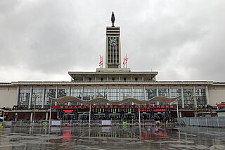
Changsha railway station is a metro station and a railway station of Beijing–Guangzhou Railway. The station is located in Furong District, Changsha, Hunan, China. The station is served by Changsha Metro Line 2.

Changsha IFS Tower T1 is a skyscraper in Changsha, Hunan, China. It is 452 metres (1,482.9 ft) tall. Construction started in 2013 and completed in 2017.

The Changsha Maglev Express, is a medium-low speed magnetic levitation, or maglev line in Changsha, China. This is China's second maglev line, after Shanghai Maglev, and the first domestically built maglev line that uses indigenous technology. The line stretches over 18.55 kilometers and runs between Changsha Huanghua International Airport, Langli station and the high-speed railway station Changsha South railway station. Its rolling stock is designed for a speed of up to 120 km/h, currently however it is running with a maximum speed of 100 km/h.
The Liuyang River, also known as Liu River or Liuwei River, is a right-bank tributary of Xiang River, the largest tributary of Xiang River in Changsha, Hunan Province, China. The river has a length of 234.8 kilometres (145.9 mi) with its drainage area of 4,665 square kilometres (1,801 sq mi), accounting for 39.47% of the total area of Changsha, with surface water resources of 4,506 million cubic meters, accounting for 41.08% of that. It flows through Liuyang City, Changsha County, Yuhua, Furong and Kaifu Districts, and merges into Xiang River at Xinhe Delta Mouth of Kaifu District.

The Laodao River, also known as the Laotang River or Liaoxu River, is a right-bank tributary of the Xiang River, the 2nd largest tributary of Xiang River in Changsha, Hunan Province, China. The river has a length of 149.35 kilometres (92.80 mi) with its drainage area of 2,543 square kilometres (982 sq mi), accounting for 21.52% of the total area of Changsha, with surface water resources of 2,262 million cubic meters, accounting for 20.62% of that. It flows through Liuyang City, Changsha County, Furong and Kaifu Districts, and merges into Xiang River at Jiangwan of Xiufeng Subdistrict, Kaifu District.