
Meldal is a municipality in Trøndelag county, Norway. It is part of the Orkdalen region. The administrative centre of the municipality is the village of Meldal. Other villages include Løkken Verk, Bjørnli, Å, and Storås.

Midtre Gauldal is a municipality in Trøndelag county, Norway. It is part of the Gauldalen region. The administrative centre of the municipality is the village of Støren. Other villages in the municipality include Singsås, Soknedal, Enodden, and Rognes.

Skaun is a municipality in Trøndelag county, Norway. It is part of the Orkdalen region. The administrative centre of the municipality is the village of Børsa. Other villages include Buvika, Eggkleiva, Melby, Skaun, and Viggja.

Klæbu is a municipality in Trøndelag county, Norway. It is located in the southern part of the Trondheim Region, about 20 kilometres (12 mi) south of the city of Trondheim. The administrative center is the village of Klæbu. The other major village in Klæbu municipality is Tanem.
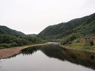
Gauldal or Gauldalen is a valley and traditional district in Trøndelag county, Norway. The river Gaula runs through the 145-kilometre (90 mi) long valley from the Røros mountains near the lake Aursunden to the Trondheimsfjorden. The narrow valley runs northwards from Røros to the Haltdalen area, where it widens some, turns and heads generally to the west to the village of Støren. At Støren it turns again and heads north through what is now a wide, agricultural valley until it reaches the sea just south of the city of Trondheim. The Rørosbanen and Dovrebanen railway lines follow the Gauldalen valley on their way to Trondheim. The European route E06 highway and the Norwegian County Road 30 also follow the valley.

Kvål is a village in the municipality of Melhus in Trøndelag county, Norway. It is located in the Gauldalen valley along the Gaula River between the villages of Ler and Melhus. The 0.45-square-kilometre (110-acre) village has a population (2018) of 458 and a population density of 1,018 inhabitants per square kilometre (2,640/sq mi).
Ler is a village in the municipality of Melhus in Trøndelag county, Norway. It is located along the Gaula River between the villages of Kvål and Lundamo. The 0.42-square-kilometre (100-acre) village has a population (2018) of 581 and a population density of 1,383 inhabitants per square kilometre (3,580/sq mi).
Horg is a former municipality in the old Sør-Trøndelag county, Norway. The 291-square-kilometre (112 sq mi) municipality existed from 1841 until its dissolution in 1964. The municipality of Horg encompassed the southern part of what is now the municipality of Melhus in Trøndelag county. The municipality included areas on both sides of the river Gaula. The administrative centre was the village of Lundamo. The main church for the municipality was Horg Church.
Hovin is a village in the municipality of Melhus in Trøndelag county, Norway. It is located along the river Gaula between the villages of Støren and Lundamo. Hovin has several distinct terraces in the hillsides, which are remnants of old shorelines following the end of the ice age.

Soknedal is a village in Midtre Gauldal municipality in Trøndelag county, Norway. The village is located along the river Sokna which flows north and later joins the river Gaula. The Dovrebanen railway line and the European route E06 highway both run through the village, heading to the city of Trondheim which is about 60 kilometres (37 mi) to the north. The village of Støren lies about 12 kilometres (7.5 mi) to the north and the village of Berkåk lies about 16 kilometres (9.9 mi) to the south.

Benna is a lake in the municipality of Melhus in Trøndelag county, Norway. The 5.9-square-kilometre (2.3 sq mi) lake is located west of the river Gaula, about 3 kilometres (1.9 mi) west of the village of Lundamo. The lake is the drinking water reservoir for Melhus municipality and a backup supply for the nearby city of Trondheim.
The Gaula is a river that flows through the Gauldal valley in Trøndelag county, Norway. The 153-kilometre (95 mi) long river is the largest in Central Norway. The river begins in Holtålen municipality near the mountain Kjølifjellet. It then flows through the municipalities of Holtålen, Midtre Gauldal, and Melhus before emptying into Trondheimsfjord near Leinstrand on the border between the municipalities of Trondheim and Melhus.
Samsjøen is a lake in Trøndelag county, Norway. The 10-square-kilometre (3.9 sq mi) lake sits on the border of the municipalities of Midtre Gauldal and Melhus. Most of the lake lies in Midtre Gauldal, about 12 kilometres (7.5 mi) north of the village of Singsås. The lake has a dam at the northwest end, which is used for hydroelectric power production. The water flows out of the lake and into the Lundesokna river which flows into the river Gaula.
Hølonda is a former municipality in the old Sør-Trøndelag county, Norway. The 167-square-kilometre (64 sq mi) municipality existed from 1865 until its dissolution in 1964. Hølonda encompassed the southwestern part of what is now the municipality of Melhus in Trøndelag county. The municipality was west of the river Gaula. The administrative centre was the village of Korsvegen. The main church for the municipality was Hølonda Church, near Gåsbakken.
Flå is a former municipality in the old Sør-Trøndelag county, Norway. The approximately 110-square-kilometre (42 sq mi) municipality existed from 1880 until its dissolution in 1964. Flå was located in the eastern part of what is now the municipality of Melhus in Trøndelag county. The administrative centre was the village of Ler. The main church for the area is Flå Church.

Horg Church is a parish church in Melhus municipality in Trøndelag county, Norway. It is located just south of the village of Lundamo, on the east side of the European route E06 highway and the river Gaula. It is the church for the Horg parish which is part of the Gauldal prosti (deanery) in the Diocese of Nidaros. The white, wooden church was built in a cruciform style in 1892 by the architect Carl J. Bergstrøm. The church seats about 700 people.

Melhus is the administrative centre of Melhus municipality in Trøndelag county, Norway. The village is located in the lower Gauldalen valley, along the river Gaula, about 15 kilometres (9.3 mi) south of the city of Trondheim. The 2.88-square-kilometre (710-acre) village has a population (2018) of 6,393 and a population density of 2,220 inhabitants per square kilometre (5,700/sq mi).
Storsand is a village in Melhus municipality in Trøndelag county, Norway. The village is located on the eastern side of the river Gaula and on the western slopes of the mountain Vassfjellet, about 2 kilometres (1.2 mi) south of the village of Melhus. The European route E06 highway and the Dovrebanen railway line both run through the village. Melhus Church is located in the village.


