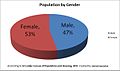
This is a demography of the population of Sri Lanka including population density, ethnicity, education level, health of the population, economic status, religious affiliations and other aspects of the population.
Padukka is a town in the district of Colombo in the Western Province of Sri Lanka. It has a population of roughly 8,000. Elevation 44feet.
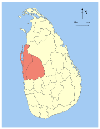
North Western Province is a province of Sri Lanka. The province consists of the districts of Kurunegala and Puttalam. Its capital is Kurunegala, which has a population of 28,571. The province is known mainly for its numerous coconut plantations. Puttalam, Kuliyapitiya, and Chilaw are the other major cities in the North Western Province. The majority of the population of Wayamba province is of Sinhalese ethnicity. There is also a substantial Sri Lankan Moor minority around Puttalam and Sri Lankan Tamils in Udappu and Munneswaram. Fishing, prawn farming and rubber tree plantations are other prominent industries of the region. The province has an area of 7,888 km2, and a population of 2,370,075.
Ratnapura is a major city in Sri Lanka. It is the capital city of Sabaragamuwa Province, as well as the Ratnapura District, and is a traditional centre for the Sri Lankan gem trade. It is located on the Kalu Ganga in south-central Sri Lanka, some 101 km (63 mi) southeast of the country's capital, Colombo. Ratnapura is also spelled as Rathnapura.
Gampaha District is one of the 25 districts of Sri Lanka, the second level administrative division of the country. It is the second most populous district of Sri Lanka after Colombo District. The district is administered by a District Secretariat headed by a District Secretary appointed by the central government of Sri Lanka. The capital of the district is the town of Gampaha. The district was carved out of the northern part of Colombo District in September 1978.

Kalutara District is one of the 25 districts of Sri Lanka, the second level administrative division of the country. The district is administered by a District Secretariat headed by a District Secretary appointed by the central government of Sri Lanka. The capital of the district is the city of Kalutara .
Matara is a district in Southern Province, Sri Lanka. It is one of 25 districts of Sri Lanka, the second level administrative division of the country. The district is administered by a District Secretariat headed by a District Secretary appointed by the central government of Sri Lanka.

Badulla District is a district in Uva Province, Sri Lanka. The entire land area of the Badulla district is 2,861 km2 (1,105 sq mi) and has a total population of 837,000. The district is bounded by the districts of Monaragala and Rathnapura on the east and south, by Ampara and Kandy districts to the north and by Nuwara Eliya and Matale to the west. Mainly the economy of the district is based on agricultural farming and livestock.

Ampara District is one of the 25 districts of Sri Lanka, the second-level administrative divisions of the country. The district is administered by a District Secretariat headed by a District Secretary appointed by the central government of Sri Lanka. The capital of the district is the town of Ampara. The district was carved out of the southern part of Batticaloa District in April 1961.

Negombo is a major city in Sri Lanka, situated on the west coast and at the mouth of the Negombo Lagoon, in the Western Province, 38 km (24 mi) from Colombo via the Colombo–Katunayake Expressway and the nearest major city from the Bandaranaike International Airport.

Kilinochchi District is one of the 25 districts of Sri Lanka, the second level administrative division of the country. The district is administered by a District Secretariat headed by a District Secretary appointed by the central government of Sri Lanka. The capital of the district is the town of Kilinochchi.
Anuradhapura is a district in North Central Province, Sri Lanka. Its area is 7,179 km².

Polonnaruwa District is one of the 25 districts of Sri Lanka, the second level administrative division of the country. It is also one of the two districts of North Central Province and has an area of 3,293 km2.

Batticaloa District is one of the 25 districts of Sri Lanka, the second level administrative division of the country. The district is administered by a District Secretariat headed by a District Secretary appointed by the central government of Sri Lanka. The capital of the district is the city of Batticaloa. Ampara District was carved out of the southern part of Batticaloa District in April 1961.
Mullaitivu District is one of the 25 districts of Sri Lanka, the second level administrative division of the country. The district is administered by a District Secretariat headed by a District Secretary appointed by the central government of Sri Lanka. The capital of the district is the town of Mullaitivu.

Trincomalee District is one of the 25 districts of Sri Lanka, the second level administrative division of the country. The district is administered by a District Secretariat headed by a District Secretary appointed by the central government of Sri Lanka. The capital of the district is the city of Trincomalee.
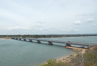
Kinniya is a town on the east coast of Sri Lanka, in the Trincomalee District of the Eastern Province. It is about 20 km (12 mi) from the city of Trincomalee and 240 km (150 mi) from Colombo. Located in Sri Lanka's dry zone, the Kinniya region often experiences hot and dry weather with very little precipitation. Kinniya Bridge is Sri Lanka's longest bridge, which attracts many tourists in the town. Being adjacent to the Trincomalee Harbour, Kinniya was devastated by the 2004 Indian Ocean tsunami.

The Central Province is one of the nine provinces of Sri Lanka. The province has an area of 5,674 km2 and a population of 2,421,148, making it the 2nd most populated province. The city of Kandy is the capital of the province.
Baduraliya is a town in the Kalutara District in Sri Lanka. It is approximately 82 km (51 mi) from Colombo and 58 km (36 mi) from Rathnapura. Baduraliya was named after a rally against taxes. "Badu" in Sinhala means taxes and “raliya” means a rally. Baduraliya is surrounded by tea plantations and rubber estates, and it is at an altitude of 27 m (89 ft) above sea level.
Nakulugamuwa is a village in the Hambantota District, Southern Province, Sri Lanka, Sri Lanka. It is located on the Tangalla Road.