
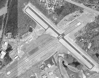
Ogdensburg International Airport is a public airport located in the town of Oswegatchie, 2 miles (3.2 km) southeast of Ogdensburg, in St. Lawrence County, New York. It is owned by the Ogdensburg Bridge & Port Authority, which also owns and operates the Ogdensburg–Prescott International Bridge, Port of Ogdensburg-Marine Terminal Facility, Commerce Park, Port of Waddington, a medium-heavy industrial park and two short line railroads. The Ogdensburg Bridge and Port Authority is a New York State public-benefit corporation. The international airport is just outside the city limits on NY 812. It is used for general aviation and commercial service. Scheduled commercial flights are operated by one airline: Breeze Airways.
Westerly State Airport is a public use airport in Washington County, Rhode Island, United States. It serves the town of Westerly and is located 2 nmi southeast of its central business district. It is primarily a general aviation airport, but there is also scheduled airline service to Block Island provided by New England Airlines.

Spadaro Airport was a privately owned, public use airport located one nautical mile (2 km) northeast of the central business district of East Moriches, in Suffolk County, New York, United States. It was included in the National Plan of Integrated Airport Systems for 2011–2015, which categorized it as a reliever airport.

York Airport (York Aviation) (IATA: THV, ICAO: KTHV, FAA LID: THV) is a privately owned, public use airport that is located seven nautical miles (8 mi, 13 km) southwest of the central business district of York in the Thomasville section of Jackson Township, York County, Pennsylvania, United States.

Lt. Warren Eaton Airport, also known as Lt. Warren E. Eaton Airport, is a county-owned public-use airport in Chenango County, New York, United States. It is located two nautical miles (4 km) north of the central business district of Norwich, New York. It was established on June 17, 1952.
May Creek Airport is a state owned, public use airport located one nautical mile (2 km) south of the central business district of May Creek, in the Valdez-Cordova Census Area of the U.S. state of Alaska. Scheduled passenger service is subsidized by the Essential Air Service program.
Minto Al Wright Airport is a state-owned public-use airport located one nautical mile (2 km) east of the central business district of Minto, in the Yukon-Koyukuk Census Area of the U.S. state of Alaska. Formerly known as Minto Airport, it was renamed in August 2009 to honor Al Wright, an Alaskan aviation pioneer and founder of Wright Air Service. Scheduled commercial airline service is subsidized by the Essential Air Service program.

Chilton County Airport, also known as Gragg-Wade Field, is a public-use airport in Chilton County, Alabama, United States. It is located one nautical mile (2 km) east of the central business district of Clanton, Alabama. It is owned by the Chilton County Airport Authority.
Ouzinkie Airport is a state-owned public-use airport serving Ouzinkie, a city on Spruce Island in the Kodiak Island Borough of the U.S. state of Alaska.
Rampart Airport is a state owned, public use airport located one nautical mile (2 km) east of the central business district of Rampart, in the Yukon-Koyukuk Census Area of the U.S. state of Alaska. Commercial service was subsidized by the Essential Air Service program until October 2016.
Thorne Bay Seaplane Base is a state-owned public-use seaplane base serving Thorne Bay, a community in the Prince of Wales-Hyder Census Area of the U.S. state of Alaska.
Port Lions Airport is a state-owned, public-use airport located two nautical miles northeast of the central business district of Port Lions, a city located on Kodiak Island in the Kodiak Island Borough of the U.S. state of Alaska.
Hyder Seaplane Base is a state owned, public use seaplane base located one nautical mile southeast of the central business district of Hyder, a community in the Prince of Wales-Hyder Census Area of the U.S. state of Alaska. It is included in the National Plan of Integrated Airport Systems for 2011–2015, which categorized it as a general aviation facility. It shares its airspace with the nearby Stewart Aerodrome and Stewart Water Aerodrome and its water runway in the Portland Canal exists on the Canada–United States border.
Port Protection Seaplane Base is a state owned, public use seaplane base located in Port Protection, a community in the Prince of Wales-Hyder Census Area of the U.S. state of Alaska. It is included in the National Plan of Integrated Airport Systems for 2011–2015, which categorized it as a general aviation facility.
North Whale Seaplane Base is a state owned, public use seaplane base located in North Whale Pass, a community in the Prince of Wales-Hyder Census Area of the U.S. state of Alaska. It is included in the National Plan of Integrated Airport Systems for 2011–2015, which categorized it as a general aviation facility.
Kobelt Airport is a privately owned, public use airport in Ulster County, New York, United States. It is located three nautical miles (6 km) northeast of the central business district of Wallkill and is also known as Kobelt/Wallkill Airport. This airport is included in the National Plan of Integrated Airport Systems for 2011–2015, which categorized it as a general aviation reliever airport.

Hollis Clark Bay Seaplane Base is a state owned, public use seaplane base located one nautical mile (2 km) northeast of the central business district of Hollis, a community in the Prince of Wales-Hyder Census Area in the U.S. state of Alaska. It was formerly known as Hollis Seaplane Base.
Marcy Field is a public-use airport located two nautical miles south of the central business district of Keene, a town in Essex County, New York, United States. It is owned by the Town of Keene. The airport is situated on the west side of the Ausable River.
Corning–Painted Post Airport is a public use airport in Steuben County, New York, United States. It is located two nautical miles (4 km) northwest of the central business district of Corning. The airport is owned by the Town of Erwin and located near Painted Post, New York. It is included in the National Plan of Integrated Airport Systems for 2011–2015, which categorized it as a general aviation facility.
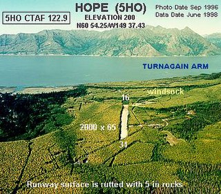
Hope Airport is a state-owned public-use airport located one nautical mile southeast of the central business district of Hope, in the Kenai Peninsula Borough of the U.S. state of Alaska. This airport is included in the FAA's National Plan of Integrated Airport Systems for 2011–2015, which categorized it as a general aviation facility.
